Thousands without power as potent low 'bombs' out over B.C.

Thousands are without power as a potent system brings powerful winds to B.C. through Tuesday.
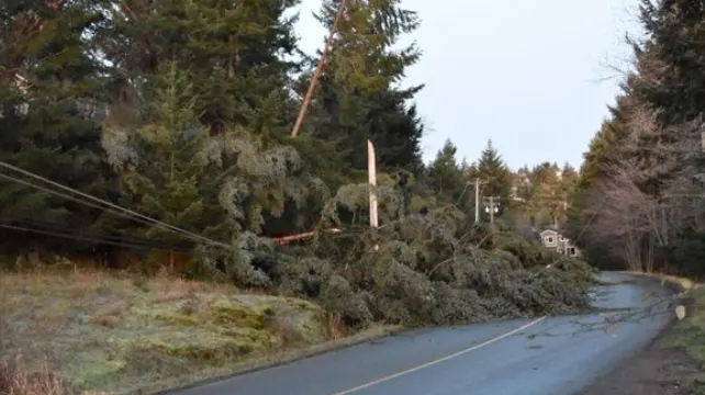
Another bomb cyclone, the third such potent low in three weeks, has left thousands without power across B.C. as damaging winds whip through the province. Before the pre-dawn hours Tuesday, around 30,000 customers were already left in the dark, though that number has dropped a fair bit since then.
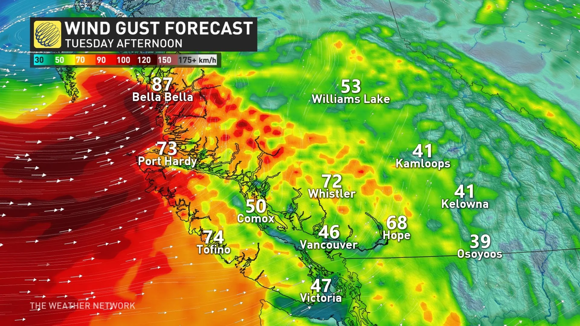
The province is currently stuck in a non-stop unsettled pattern that won't budge. These fierce wind gusts could cause additional power outages for the North and Central coasts, and northern Vancouver Island, with much less intense but still strong winds lingering through the day Tuesday for the Lower Mainland. In addition to the rain and wind threat, there's also the chance for severe thunderstorms inching into the South Coast on Tuesday. Details on timing and impacts, below.
TUESDAY: POWERFUL WINDS KNOCK OUT POWER TO THOUSANDS
Another intense, but slow-moving Pacific front is crawling through the B.C. coast, bringing heavy rain, powerful wind gusts and copious snowfall for the mountain passes through Tuesday. The latest in a parade of systems is all due to a broad upper trough stationed over the Gulf of Alaska.
In fact, it's the third system in less than three weeks that has reached "weather bomb" criteria, which is a system thats pressure drops at least 24 millibars in 24 hours.
Before the pre-dawn hours on Tuesday, BC Hydro had reported that about 30,000 customers were without power, with the majority of the outages reported across the Lower Mainland and Sunshine Coast. By 12 p.m. PST, that number has dropped slightly to more than 21,000.
According to officials, most of the outages occurred when the winds picked up through the overnight hours, with falling trees knocking out power linds.
The winds will shift directions through Tuesday morning for the southern Gulf Islands, Sunshine Coast and Lower Mainland in the wake of the system, but with gusts between 40-60 km/h still continuing through the day. For Howe Sound, winds will quickly switch to southwesterly inflow with speeds of 50 km/h gusting to 80 km/h.
"Damage to buildings, such as to roof shingles and windows, may occur. Loose objects may be tossed by the wind and cause injury or damage. High winds may toss loose objects or cause tree branches to break," Environment and Climate Change Canada says in the wind warning.
RELATED: How Vancouver, B.C, pulled off the tornado upset of the century
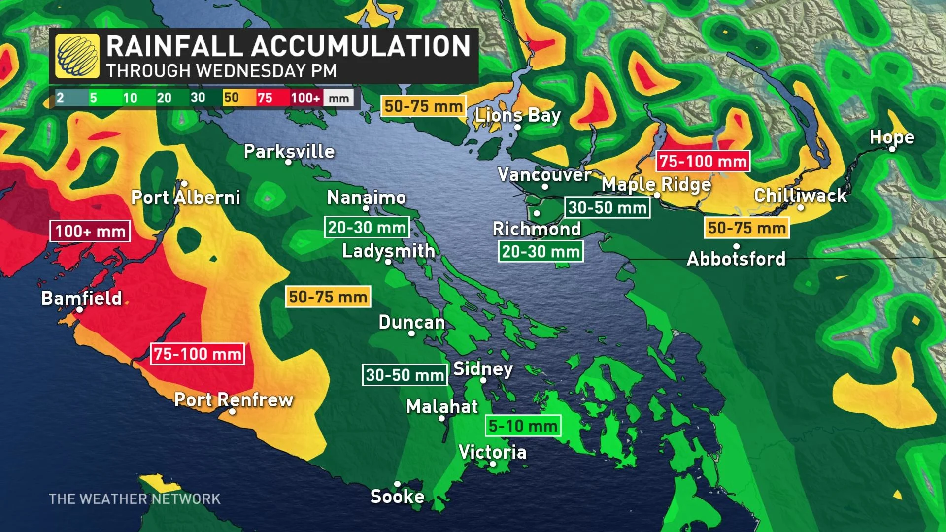
Rain will be ongoing for the coastal regions and Lower Mainland through Tuesday afternoon before beginning to subside in the evening hours.
Through Wednesday night, totals of 30-50 mm are expected for the Lower Mainland, while some areas along the western coast of Vancouver Island could see 100+ mm of rainfall during the same time period.
In addition to the rain and wind, a severe thunderstorm risk is also inching close to southern B.C.
While tornadoes are extremely rare for the South Coast, it's not completely unheard of, as was the case with a confirmed EFO tornado just this past weekend. The atmosphere on Tuesday is eerily similar to Saturday, with a very low risk for a tornado to occur.
MUST SEE: How Vancouver, B.C, pulled off the tornado upset of the century
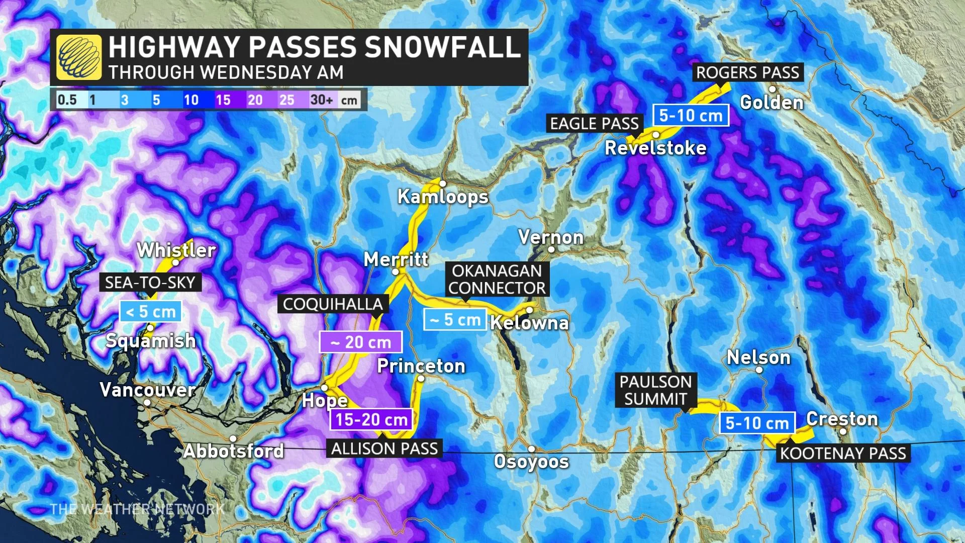
SNOWFALL WARNINGS IN EFFECT FOR THE COQUIHALLA HIGHWAY
The constant cavalcade of storms along the coast has allowed Arctic air to reach southern B.C. Freezing levels won't lift above 1000 metres until Thursday.
Snowfall will be a given for the mountain passes, with accumulations hitting up to 20 cm for the Coquihalla and Allison Pass regions. As a result, snowfall warnings are in effect, with hazardous travel expected in these regions.
Because of the lower freezing levels, there will be the chance for mixing to reach some of the higher communities along the periphery of the Lower Mainland.
LOOK AHEAD: STUBBORN RAINY PATTERN REFUSES TO LET UP, ALONG WITH HEFTY AMOUNT OF ALPINE SNOW
The unsettled pattern continues for the B.C. coast into early next week, but with some brief breaks between systems.
The low north of Vancouver Island will eventually die out by Wednesday, but high pressure south of the border will redirect some residual moisture into the South Coast as it runs into that cold air.
Freezing levels will remain low this week and that means more snow for many ski areas including Whistler, with higher accumulations for the higher alpine.
The North Shore Mountains may see 100 cm through Wednesday.
The levels will rise above 2000 metres with the late-week system, then drop to near 1000 metres again this weekend.
Be sure to check back for the latest updates on the weather in B.C.
Thumbnail image courtesy: BC Hydro/Twitter