
Spring snowstorm closes schools, cancels flights for parts of East Coast

Snowfall and winter storm warnings cover parts of Atlantic Canada for a potent spring system that threatens 20+ cm of snow.
The calendar says spring and we have just kicked off April, but winter's wrath continues to ferociously hit parts of the East Coast. Several schools across Nova Scotia closed their doors early Monday, with 10-20+ cm of snow expected to hit parts of the province throughout the day. Both air and ferry travel have also been impacted, with travellers being urged to adjust any plans accordingly. Snowfall amounts will be greatest along the Atlantic coast and over eastern areas, where snowfall warnings have been issued for the region. The system will continue to make its way into Newfoundland for Tuesday, with heavy snow and gusty winds prompted winter storm warnings for some areas. More on the impacts and timing as we kick off this first full week of April, below.
MUST SEE: Deprived of warmth: Patience will pay off for Canadians in the cold
MONDAY INTO TUESDAY: HEAVY SNOW SPANS PARTS OF THE EAST COAST, BRACE FOR TRAVEL IMPACTS
Snow pushed into Nova Scotia ahead of the morning commute on Monday, with drivers being urged to adjust to the changing conditions throughout the day. Several schools opted to close first thing as well, in anticiaption of the quickly accumulating snow and deteriorating conditions.
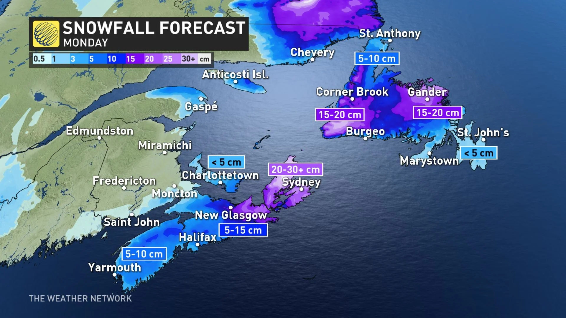
In all, between 10-20 cm of snow is expected across the province throughout the day, with as much as 30 cm possible in eastern sections.
Some of this wet snow might struggle to accumulate due to the marginal temperatures, however. Areas near the water are likely to see snow melt on contact, while areas over higher terrain and away from the water have higher odds of accumulating significant snow.
"Be prepared to adjust your driving with changing road conditions. Visibility may be suddenly reduced at times in heavy snow. Surfaces such as highways, roads, walkways and parking lots may become difficult to navigate due to accumulating snow," Environment and Climate Change Canada (ECCC) says in the snowfall warning for Halifax.
SCHOOLS CLOSE ON MAINLAND NOVA SCOTIA AS SNOWY CONDITIONS CONTINUE
In addition to the poor road conditions, the Halifax Stanfield International Airport also suspended its runway operations due to the snow. Several flights in and out of the airport were reported as delayed or cancelled Monday morning. Marine Atlantic postponed the morning ferry crossing from Port aux Basques, N.L., to North Sydney.
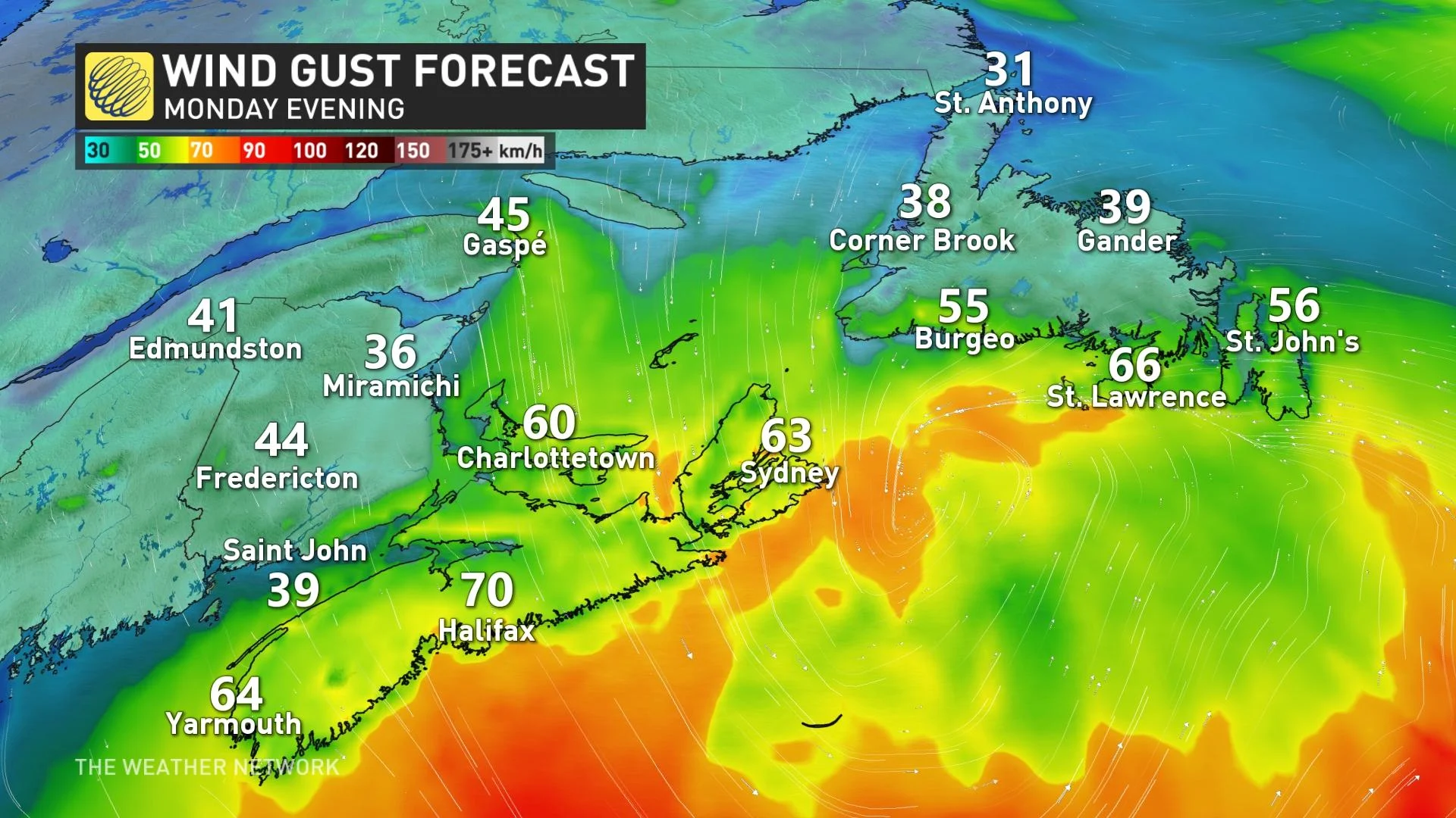
Adding insult to injury, winds will ramp up on Monday afternoon, with 60-70+ km/h gusts along southern Nova Scotia shores and possibly exceeding 80 km/h for southern Newfoundland in the evening.
The snow will begin to ease off in the Maritimes on Monday evening, with sea-effect lingering on the backside of the low across eastern sections, including Cape Breton through Tuesday afternoon.
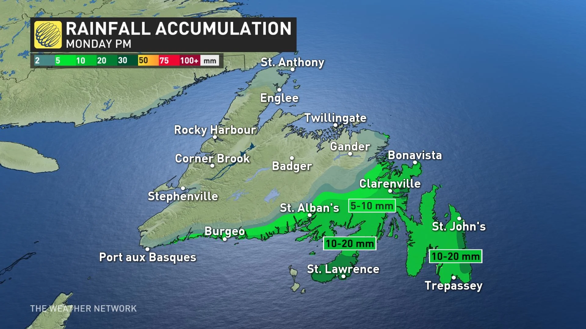
The system will produce a messy mix across Newfoundland, including hefty snowfall for western areas, set to linger through much of Tuesday. The island will also see sea-effect snow behind the low into Wednesday morning.
Across western Newfoundland, a wide range of 5-25 cm of snow is possible, depending on location, while precipitation manifests as rain for southern sections. The heaviest snowfall will occur on the western and eastern coasts, with the latter possibly picking up totals as high as 25 cm.
Beyond the system, temperatures will be quite chilly, but then will trend milder and unsettled once more late week and next weekend.
Check back as we continue to monitor the Atlantic Canada forecast.