Sentinel 6 reaches space to track climate change impacts on Earth's oceans

This is the first of two identical satellites that will continue observations of sea level change for at least the next decade.
Earth's ocean levels are rising due to climate change. NASA, the ESA, and SpaceX have just launched the next satellite to track these changes and help us better protect our vulnerable coastlines as the world continues to warm.
On Saturday, November 21, at 12:17 p.m. EST, the Sentinel 6 Michael Freilich satellite launched into space from Vandenberg Air Force Base, near Los Angeles, California. Perched atop one of SpaceX's Falcon 9 booster rockets, Sentinel 6 reached orbit in a matter of minutes. It will now provide the most accurate measurements of sea level rise to date, for at least the next five years.
Watch NASA and SpaceX launch Sentinel 6 into space
Sentinel 6 is a joint mission for NASA and the European Space Agency. It now joins the ESA's Copernicus Programme, continuing a record of sea level measurements that began in 1992 with the TOPEX/Poseidon satellite.
Unlike other satellites of its type, Sentinel 6 bears a name. This is typically reserved for space telescopes, such as Hubble or Fermi, but this satellite is special. It has been named after the former director of NASA's Earth Science Division, Dr. Michael Freilich.

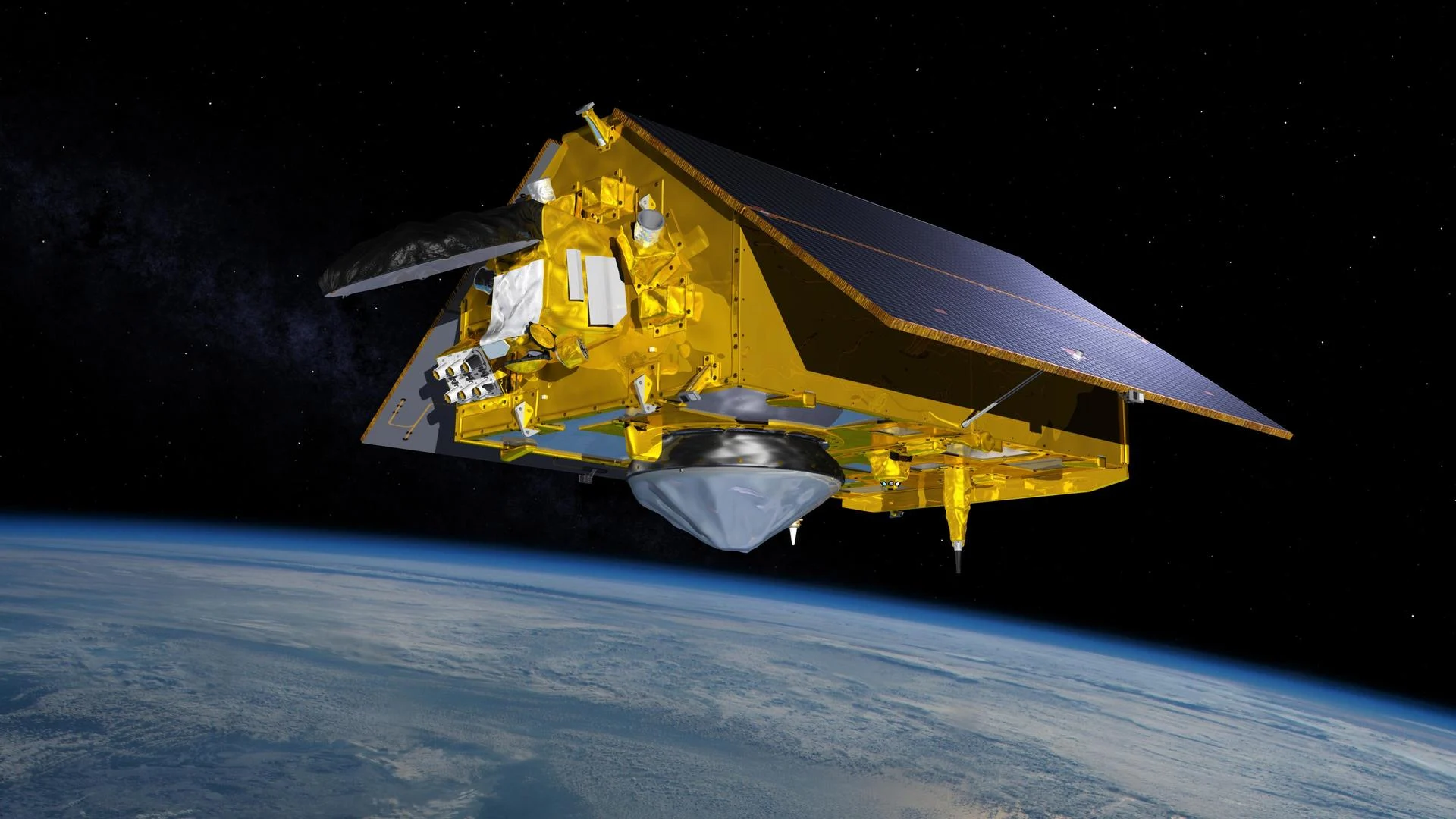
The NASA-ESA Sentinel 6 satellite is depicted in orbit around Earth in this artist's conception drawing. Sentinel 6 will map Earth's oceans every 10 days to track sea level rise due to climate change. Credit: NASA/JPL-Caltech
"Mike helped ensure NASA was a steadfast partner with scientists and space agencies worldwide, and his love of oceanography and Earth science helped us improve understanding of our beautiful planet," Thomas Zurbuchen, the associate administrator for science at NASA Headquarters, said in a press release. "This satellite so graciously named for him by our European partners will carry out the critical work Mike so believed in — adding to a legacy of crucial data about our oceans and paying it forward for the benefit of future generations."
SEA LEVEL RISE
Sea levels have already risen by about 10 centimetres since satellite measurements began in the early 1990s. However, ground measurements going back to the late 1800s show that the oceans are now around 25 centimetres higher than they were in pre-industrial times. Furthermore, the rate of sea level rise is accelerating.
Averaged over the entirety of Earth's oceans, the rate of rising over the past 28 years has been calculated at just over 3 millimetres per decade.
Due to the accelerating loss of ice from the Greenland and Antarctic ice sheets and thermal expansion as ocean waters warm, the rate of rising has gone up to around 4 mm/decade in recent years. At this rate, NASA says that sea levels could be up to 60 centimetres higher by 2100.
Watch Below: Sea level rise accelerates over time
IMPACTS ON COASTLINES
Many coastal communities are already seeing the impacts climate change is having on our oceans.
Islands in the South Pacific are being inundated by tides. The city of Miami, FL, is considered one of the most vulnerable to sea level rise in the world. Even as the city continues to develop, work crews now install pumps under streets and buildings to shunt seawater back into the ocean. Here at home, Canada is feeling its own impacts from sea level rise, with high waves and stronger storm surges.

Sentinel 6's laser altimeter in action, sending pulses of light down to the ocean surface, where they are reflected back to the satellite for measurement. The exact timing of the reflected light provides the measurement for sea level. Credit: ESA/Scott Sutherland
Previous ocean-monitoring satellites were used to track larger-scale patterns, like El Niño and La Niña. Sentinel 6's advanced instruments will return higher resolution measurements, allowing scientists to better track the smaller-scale impacts that have the most significant effect on coastlines.
With a better idea of how quickly these impacts will be felt along coastlines, residents can be better informed of what to expect. Meanwhile, governments can make better plans for mitigating the worst effects.
NEW WEATHER SENSING
While Sentinel 6's primary mission is ocean observation, the satellite will also be providing new measurements of the atmosphere to help meteorologists and atmospheric scientists.
The Advanced Microwave Radiometer (AMR) will beam signals into the atmosphere tuned at just the right wavelength to provide modellers and forecasters with high-resolution measurements of humidity.
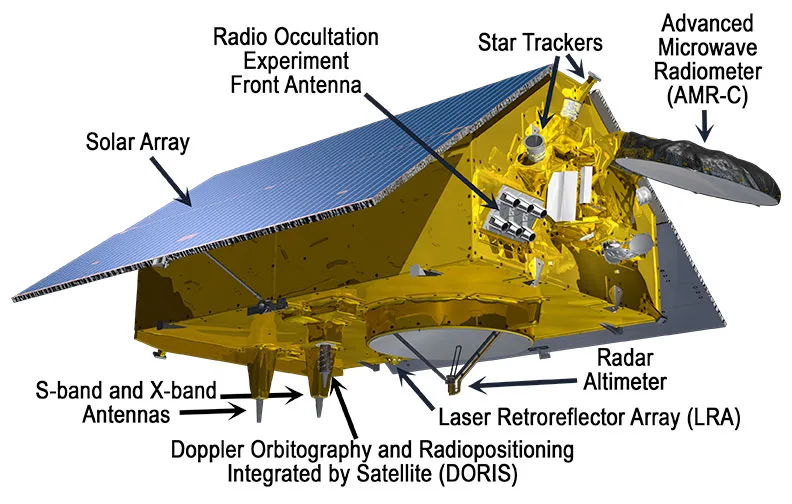
This artist's rendition of the Sentinel 6 satellite reveals the array of instruments that dot the spacecraft's surface. Credit: NASA/JPL-Caltech
The spacecraft's Global Navigation Satellite System - Radio Occultation (GNSS-RO) antennas will also provide new weather data. Rather than sensing weather conditions directly, however, this instrument measures the exact timing of radio signals received from Global Positioning System (GPS) satellites in geostationary orbit. The amount of delay and 'bending' detected in these signals as they pass through the different layers of the atmosphere can help meteorologists determine the temperature, pressure, and humidity of the air the signals passed through. They can even reveal the conditions in Earth's ionosphere, which can help in forecasting space weather impacts.
According to NASA: These combined measurements will give meteorologists further insights to improve weather forecasts. Moreover, information on the temperature and humidity of the atmosphere, as well as the temperature of the upper layer of the ocean, will help to improve models that track the formation and evolution of hurricanes.
"The Earth is changing, and this satellite will help deepen our understanding of how," Karen St. Germain, Director of NASA's Earth Science Division, said in a press release on Saturday. "The changing Earth processes are affecting sea level globally, but the impact on local communities varies widely. International collaboration is critical to both understanding these changes and informing coastal communities around the world."