Quebec: Schools close amid April ice storm, big snow follows

Another round of wintry weather targets southern Quebec after over 300,000 were left in the dark from Monday's icy blast.
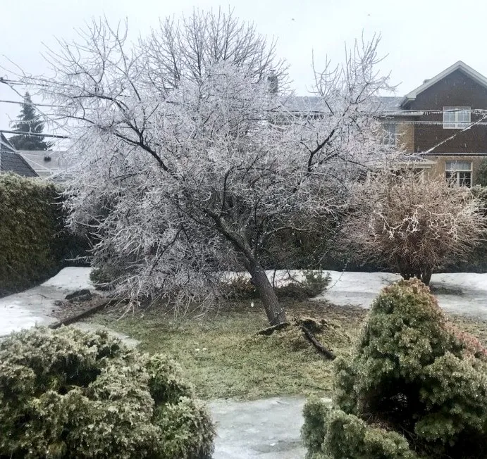
Monday brought an icy, snowy mess to much of southern Quebec, leaving roughly 310,000 Hydro-Québec customers without power by 9 p.m. A quarter of a million were still without power early Tuesday prompting several school boards to close schools for the day just as another system targets the province with the next helping of ice and snow. We break down the timing of this latest winter comeback, and why temperatures will be slow to recover, below.
Spring is here! Check our UPDATED Spring Forecast to see what the season has ahead, plus get an EXCLUSIVE sneak peek at Summer 2019!
WEATHER HIGHLIGHTS:
Snow moves in again for Montreal, Eastern Townships, Quebec City for Tuesday
Significant accumulation expected along St. Lawrence River
Temperatures recover slowly through week; little hope for prolonged warmth in April
Latest watches and warnings HERE
SCHOOLS CLOSE, POWER KNOCKED OUT TO THOUSANDS
After a period of prolonged freezing rain and powerful winds wreaked havoc on Quebec hydro lines on Monday, roughly 250,000 remained without power early Tuesday morning. That prompted school boards in Laval, the Laurentians and the Lanaudière regions to close schools for the day as Hydro-Québec employees work around the clock to get everyone back online. There have also been outages in Montreal as well as the Montérégie, Mauricie and Outaouais regions.
By 9 p.m. Monday night, about 310,000 customers were in the dark with officials blaming the icy conditions and high winds for the widespread outages. And while the heaviest of the preciptation tapered off through the overnight hours on Monday, the wintry weather is far from over as an Alberta clipper moves through on Tuesday. That means even more snow and ice are in the forecast, putting some additional strain and weight on the already crippled powerlines.
"This will likely be a long duration power outage," says Weather Network meteorologist Tyler Hamilton. "I don't want to speculate, but it's going to take a long time for crews from Hydro-Québec to get things back together."
Emergency officials are urging residents to take extra precautions in regards to the outages as carbon monoxide poisoning, fires and traffic pileups have all been reported. In Laval, police have been going door-to-door to check on those in vulnerable positions and are encourgaing others to check on friends and relatives that may have been affected.
WATCH BELOW: ANOTHER ROUND OF WINTER WEATHER
ADDITIONAL HEAVY SNOW THROUGH WEDNESDAY
After a short break, snow moves back into the Montreal area on Tuesday picking up in intensity through the early to mid-afternoon hours. And while the heaviest band is expected to fall further east through Trois-Rivières and toward Quebec City, Montreal still stands to see 10 to 15 cm of snow to follow Monday's ice.
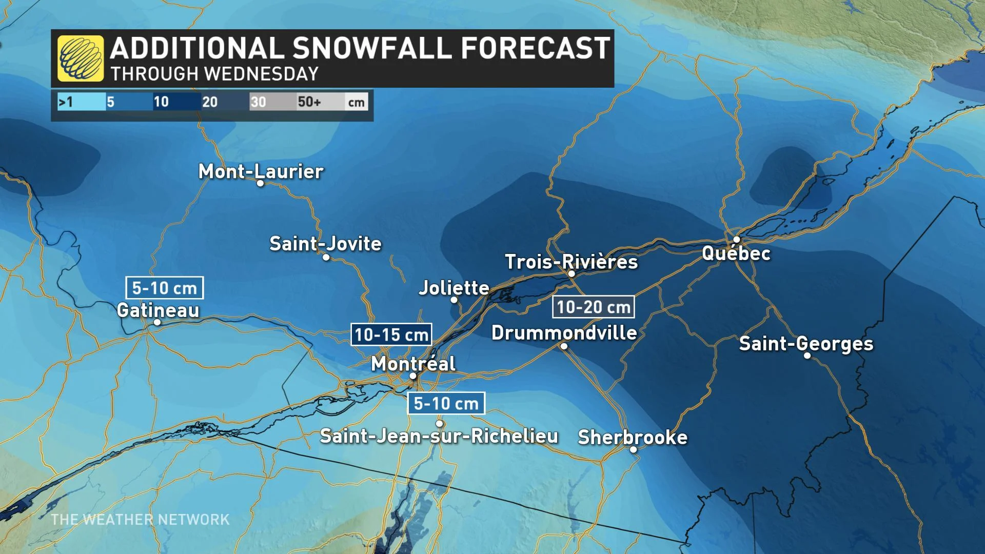
"The second sytem moves in on Tuesday morning and afternoon, and this is where we're going to be looking at heavier snow for the Montreal and Gatineau regions, eventually making its way further north and east towards Quebec City," says Weather Network meteorologist Kelly Sonnenburg.
According to Sonnenburg, some of these snow totals between the Monday and early Wednesday morning, when snow tapers off for Quebec City, could amount to more than a month's worth for some areas, all relative to what's typically recorded through the entire month of April.
In addition, strong wind gusts between 50-60 km/h combined with the freshly fallen snow could make for some treacherous travel conditions.
SEE ALSO: Congratulations? Ottawa sets epic wintry record
UNSETTLED PATTERN PERSISTS THIS WEEK
A broad upper-level disturbance remains anchored over eastern Canada for much of this week, and that means even after the early-week system moves away, the risk for snow showers remains for much of the southern half of the province.
"An atmospheric blocking pattern will develop and persist through at least April 20th," says Weather Network meteorologist Dr. Doug Gillham, who calls the pattern "eerily similar" to both last April and April 2016.
"This will bring colder than seasonal temperatures April 10-20 from the eastern Prairies to the Maritimes – and no sustained warmth is in sight.
Stay tuned to The Weather Network for your latest forecast updates.
CLICK TO PLAY: WIDESPREAD POWER OUTAGES AND SCHOOL CLOSURES ACROSS LAVAL, QC
With files from CBC