Prepare now for dangerous snow squalls for parts of southern Ontario

Travel will be extremely dangerous and downright impossible at times for parts of southern Ontario as intense snow squalls set up through the weekend.
Rounds of intense snow squalls will continue building over parts of southern Ontario heading into the end of the workweek as cold winds blow over the unusually warm waters of the Great Lakes.
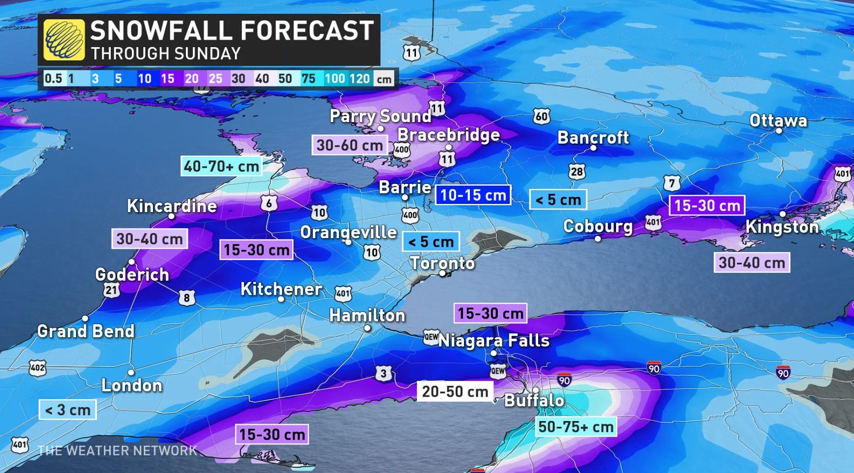
Some parts of the province could see thigh-high snow by Sunday, a walloping that will significantly disrupt travel through the affected areas.
DON'T MISS: Intense squalls could bury this major city under 100+ cm of snow
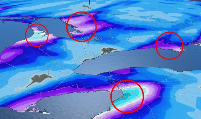
We’re watching four separate targets for bands of heavy lake-effect snow to develop in the coming days.
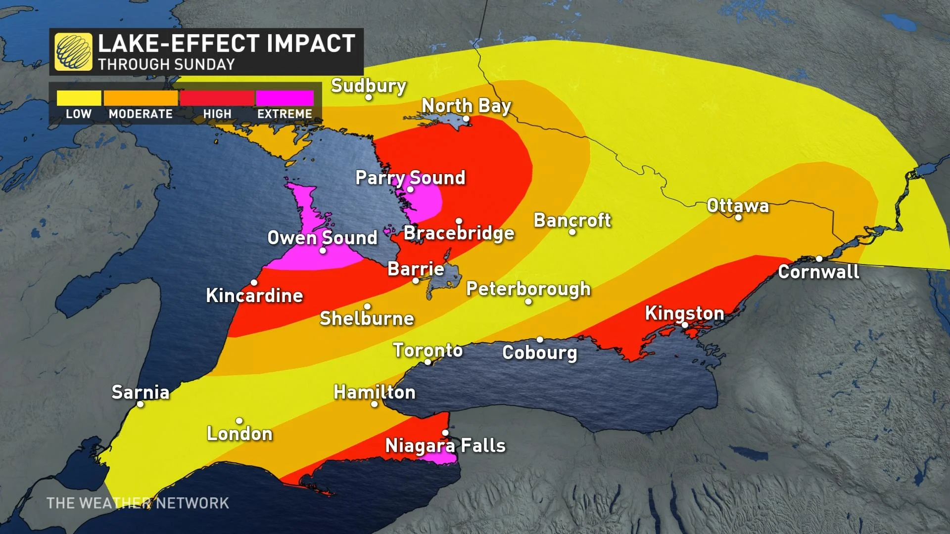
Communities east and northeast of Lake Huron, Georgian Bay, Lake Erie, and Lake Ontario will have to be on the lookout for rapidly changing conditions heading into the weekend.
WATCH: Timing out the snow across the Niagara region
It’s a classic setup for significant lake-effect snow — cold westerly and southwesterly winds blowing over the warmer lakes will lead to multiple bands of snow rolling onto the lakeshores.
The orientation of the winds will favour thick, persistent bands of snow over narrower, gentler bands, which will dump mounds of snow on some communities while others nearby will see more manageable totals.
The direction of the winds will play a key role in both how much snow falls and where the heaviest snows will occur.
RELATED: Why this ‘perfect lake-effect storm’ could produce 100 cm of snow
Travel will become treacherous or downright impossible during the heaviest bands of snow, where visibility may approach zero at times and roads will quickly become impassable due to rapid snow accumulation.
"Road closures are possible," says Environment and Climate Change Canada (ECCC) in a snow squall watch issued early Friday. "Consider postponing non-essential travel until conditions improve. If you must travel, keep others informed of your schedule and destination and carry an emergency kit and mobile phone."
Danger zones: Areas at risk for impactful snowfall totals
We should also add some info about the Grey-Bruce and Muskoka squalls
Squalls will really intensify for the Grey-Bruce and Muskoka regions on Friday, persisting through much of the weekend. For the Muskoka area, squalls will start near Gravenhurst and Bracebridge, and on Saturday, shift north before shifting back south overnight into Sunday. The Bruce Peninsula could see some of the highest snowfall accumulations in southern Ontario with a persistent squall of the region through Sunday morning.
Very heavy snow is possible across the Niagara Peninsula as well, with the potential for a sharp gradient between intense snow and a sightly winter scene.
MUST SEE: Buried: Why the Great Lakes produce some of the world’s heaviest snow
The worst conditions for the Niagara region and the northern shores of Lake Erie will be on Saturday, with areas from Long Point to Fort Erie seeing the worst of it. St. Catharines and Niagara Falls will be threatened with some pretty intense squalls for a few hours on Saturday as well.
WATCH: 72cm in 72 hours is expected in Ontario
Farther north, the areas along Lake Ontario at greatest risk for disruptive snow will fall along the 401 in and east of Cobourg. This region is prone to rapidly reduced visibilities due to the proximity of Lake Ontario, so those travelling should be prepared for near whiteout conditions on Saturday.
Due to the nature of lake-effect snow, storm totals will vary widely over short distances and between one community and another. Widespread totals of 25+ cm are possible throughout the region, with localized amounts of 50+ cm possible under the heaviest and most stubborn bands that develop.
WATCH: Powerful Buffalo squalls put into perspective as car completely buried
Stay tuned to The Weather Network as we monitor this developing lake-effect snow event.