
Powerful winds will continue across Atlantic Canada into Sunday

A formidable storm rolling across the East Coast will continue producing whipping winds and bouts of rain and snow into the day on Sunday.
It was a rough Saturday across Atlantic Canada as powerful winds, heavy snow, and drenching rains buffeted the region. While the system will quickly pull to the north through early Sunday, we’re not quite done with its ill effects just yet. Blustery conditions, cold air, and accumulating snow is likely behind the system into the day on Sunday. More on what to expect Sunday and a look at the week ahead, below.
Visit our Complete Guide to Spring 2022 for an in-depth look at the Spring Forecast, tips to plan for it and much more!
SATURDAY NIGHT AND SUNDAY: WICKED STORM CONTINUES
Rainfall, snowfall, and blizzard warnings continue across the Atlantic provinces as a damaging and potentially record-breaking storm continues to roar through the region.
The system will reach its peak intensity overnight Saturday into Sunday over the Gulf of St. Lawrence.
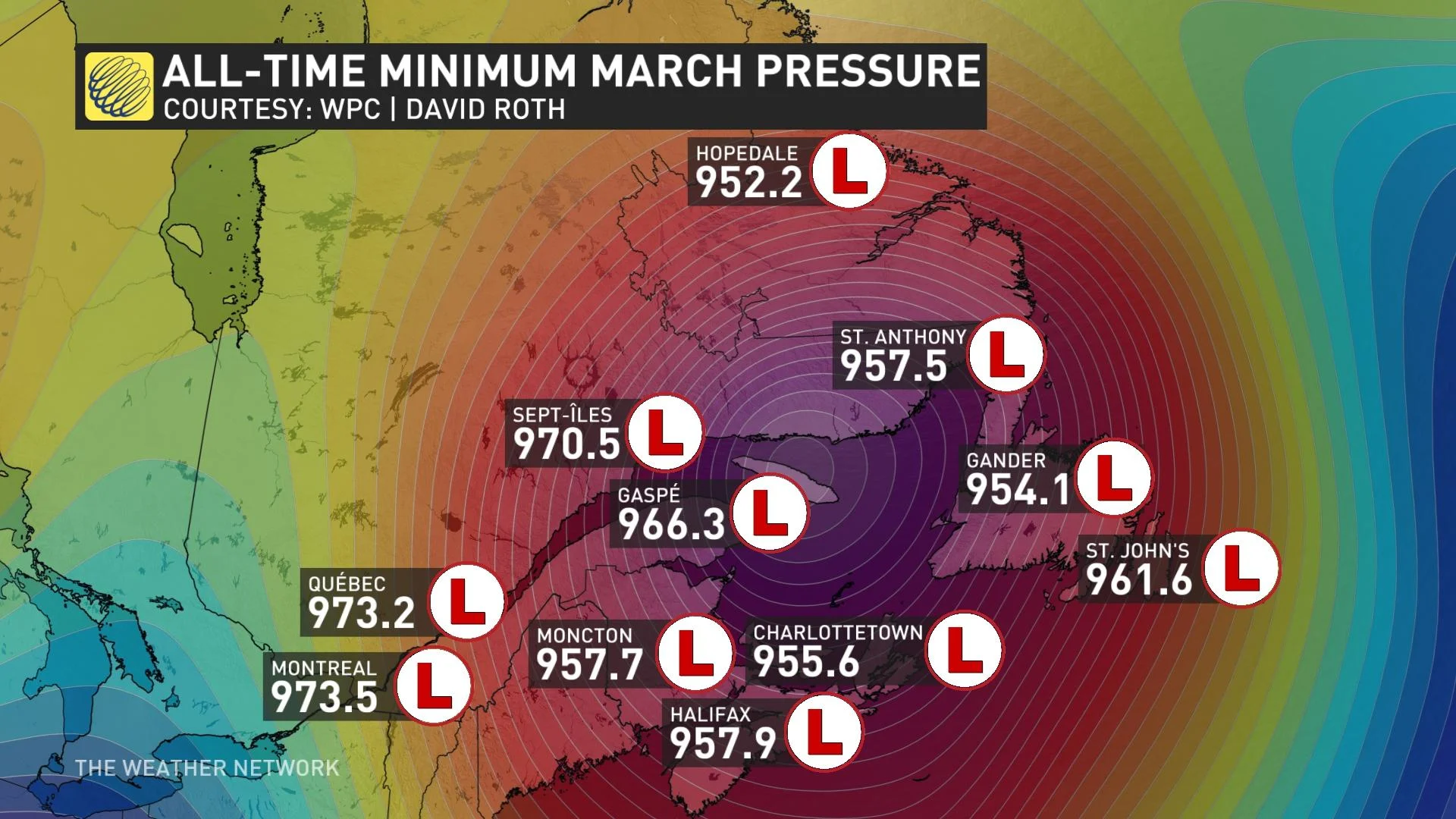
If the centre of the storm happens to pass near any of these official observation stations across the region, it would break the record as the deepest low-pressure system recorded in Canada during the month of March, according to Tyler Hamilton, a meteorologist at The Weather Network.
MUST SEE: Sprawling winter storm leaves footprint longer than the width of Canada
The bulk of the precipitation fell over the Maritimes during the day on Saturday. Lingering rain will slowly transition over to snow across the region overnight into Sunday morning as northwesterly winds usher in subfreezing temperatures behind the system.

We won’t see much in the way of accumulation in the Maritimes, with trace amounts for much of Nova Scotia and less than 5 cm of snow expected across Prince Edward Island and the southern half of New Brunswick. Watch out for patches of black ice with wet roadways and air temperatures sinking below the freezing mark.
Heavy rain will continue through the overnight hours for southern Newfoundland, where we could see an additional 15-30 mm of rain across the Avalon. Heavier totals are likely along the southern coast around Burgeo, where an additional 30-50 mm of rain could fall through Sunday.

The biggest issue will continue to be powerful wind gusts, which could reach 90-100 km/h across the Maritimes through the overnight hours. Winds in the Maritimes will slowly calm from west to east heading into early Sunday morning.
The strongest winds are yet to come for Newfoundland, where the southern coasts could see gusts of 120+ km/h at times through the first half of Sunday. Winds will continue to gust to 90-100 km/h across Newfoundland into early Monday morning. Watch out for downed trees and power lines, and make sure you’re ready for any potential power outages after dark.
WATCH: WINDS RAMP UP FOR NOVA SCOTIA; POWER OUTAGES & TRAVEL DISRUPTIONS POSSIBLE
MONDAY AND BEYOND: TEMPERATURE ROLLER-COASTER BEHIND THE STORM
We’ll remain locked in a colder pattern across Atlantic Canada to start the week. Monday’s daytime highs will remain below freezing for St. John’s, while most of the Maritimes will see highs in the lower single digits.
Looking ahead to the rest of the week, we’ll see a temperature roller coaster as several systems trek across the region.
Each day will seesaw between colder- and warmer-than-seasonal temperatures. Tuesday looks warmer, Wednesday looks chilly, and the end of the week looks warmer again. This pattern will also feature several opportunities for precipitation across the region, but we shouldn’t see any major storms.
Stay tuned to The Weather Network for all the latest on this major East Coast storm.