
Ontario: Significant weekend snow, expect travel impacts

A Colorado low will track through the Great Lakes region on Saturday with the threat for significant snow and gusty winds.
The last of the snow squalls will be long gone by Friday morning in southern Ontario, leaving behind a drop in temperatures as much as 10 degrees below seasonal. Starting Friday night, the next weather maker, a potent Colorado low, is set to deliver widespread snow across southern Ontario this weekend. More on the blustery conditions that end this week, and the travel issues with the heavier snow expected for the weekend, below.
WEATHER HIGHLIGHTS:
Colorado low tracks in for Saturday, widespread snow threat through southern Ontario
Road and air travel impacts possible
Much colder weather locks in for early next week
Stay up-to-date on the ALERTS in your area
FRIDAY: TEMPERATURES FALL AHEAD OF POTENT WEEKEND SYSTEM
Shifting bands of lake effect snow brought a few flakes to parts of the south Thursday, along with some graupel, though waning through the overnight hours.
By Friday, southern Ontario will be home to the coldest air we've seen so far in 2020, with daytime highs running close to 10 degrees below average. It's partly that pool of cold air that has forecasters' attention focused on the weekend ahead.
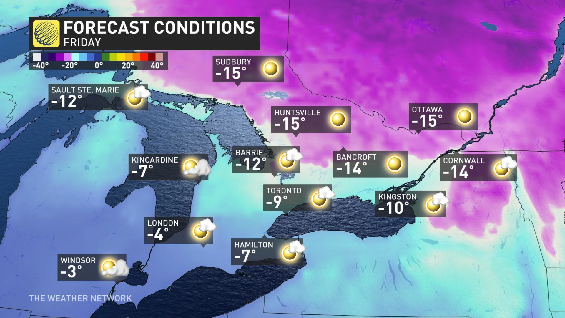
The good news is that temperatures will recover somewhat into the weekend, but will remain cold enough to affect how an approaching weekend system will manifest when it reaches southern Ontario.
DON'T MISS: Why road salt can be ineffective against removing snow and ice
SATURDAY: SIGNIFICANT WEEKEND SNOW, STRONG GUSTY WINDS
Unlike last weekend, when temperatures were warm enough to support first epic downpours, then significant freezing rain for some, this will mostly be a snow event, beginning Friday overnight and continuing through Saturday morning. However, there will be some exceptions for parts of the day.
WATCH BELOW: TRACK THE APPROACH OF THIS SIGNIFICANT STORM
The effects of this Colorado low begin as snow for most people, reaching the Golden Horseshoe by around 6 or 7 a.m. Saturday morning and the Ottawa area by noon.
By late morning, the snow will briefly transition to a rain/snow mix, or light rain, through Saturday afternoon. For the Golden Horseshoe, snowfall continues into the mid-afternoon before making that transition.
That light rain will transition back to snow through southwestern Ontario by Saturday evening. For areas south of the 401 from Kingston to Toronto and beyond to Hamilton and Niagara, light rain or drizzle continues into the mid-afternoon.
For most places, precipitation transitions back to snow as the system departs Saturday night.
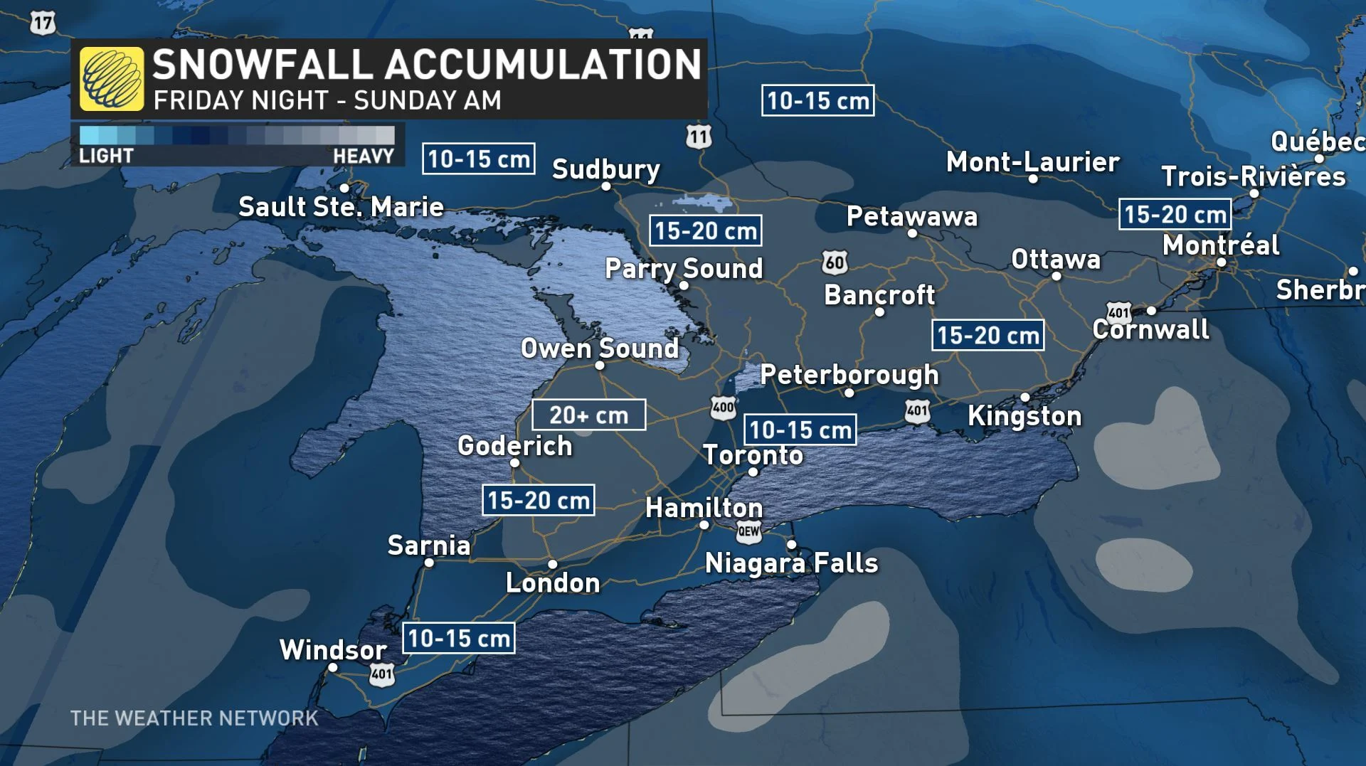
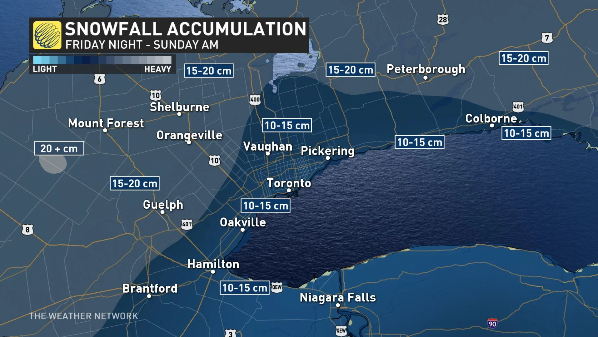
Snowfall amounts in general will range from 10-20 cm for almost all of southern Ontario, heaviest near the Bruce Peninsula and Dundalk Highlands. The heaviest snowfall rates for the GTA will be in the mid-morning.
Accompanying this system will be blustery winds gusting in the 50-60 km/h range Saturday, ramping up to 60-80 km/h overnight into Sunday morning, strongest along the northeastern shore of Lake Erie.
SUNDAY: ARCTIC AIR SETTLES IN, MORE LAKE-EFFECT SQUALLS
Light flurries linger into the early morning for the GTA, while the snow will end for the Ottawa region by the 8 o'clock hour.
Behind the storm system, arctic air will plunge into the region, staying colder for the start of next week as well.
"Sunday will be blustery and cold with blowing snow and bands of lake effect snow squalls southeast of Lake Huron and Georgian Bay," adds Weather Network meteorologist Dr. Doug Gillham.
In fact, this could be the start of the more "typical" winter weather as colder conditions lock in for the second half of January and into the beginning of February.