
Potentially historic blizzard may be the Prairies' 'worst' in decades

The forthcoming blizzard has the potential to be the Prairies' worst in decades, with widespread disruptions to travel, power and school expected for multiple days.
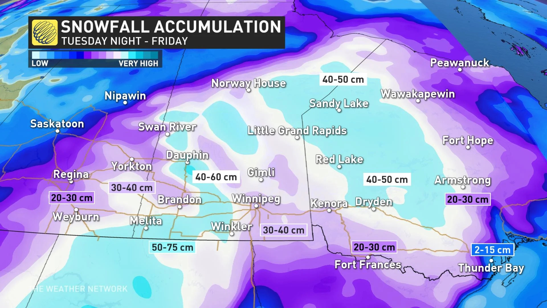
History could be made on the eastern Prairies, with a major, prolonged spring blizzard anticipated to wallop southern Manitoba, southeastern Saskatchewan and northwestern Ontario Wednesday to Friday. In fact, Environment and Climate Change Canada (ECCC) says it has the potential to be the worst blizzard in decades. People should prepare now for widespread, significant disruptions to travel, power and schools. By the time it ends, some spots may see as much as 75 cm of snow. More on the timing and what you can expect over the coming days, below.
DON'T MISS: Red River flood risk low, but Manitoba isn't out of the woods yet
THIS WEEK: MAJOR SPRING BLIZZARD THREATENS DANGEROUS TRAVEL, EXTENDED POWER OUTAGES, ROAD CLOSURES
Thanks to a trough, temperatures plunging well below normal will set the stage for a major snowstorm for parts of southeastern Saskatchewan, southern Manitoba, and northwestern Ontario during the latter half of the week.
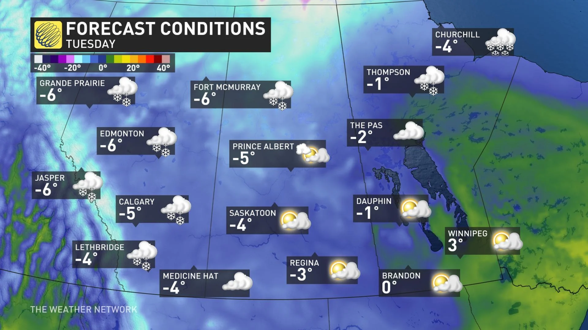
Tuesday will see single-digit values in Manitoba, temperatures you wouldn't expect right before a significant snow event.
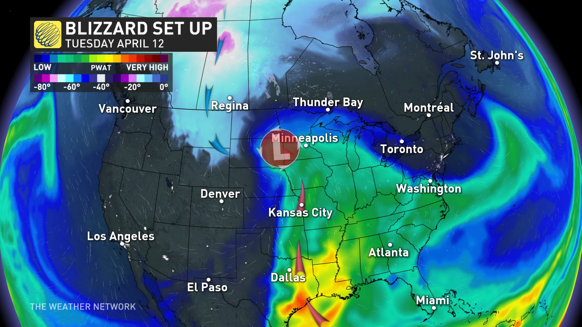
A Colorado low will rapidly intensify as it tracks into the U.S. Midwest and eventually pulls into Manitoba and northwestern Ontario. This will be a disruptive system south of the border, with the threat for blizzard conditions across the northern Plains and several days of severe thunderstorms for the southern half of the Plains and the Deep South states.
The snow will start early Tuesday evening near the international border then push northward throughout the overnight. By Wednesday morning, heavy snow will be falling in much of southeastern Saskatchewan, southern Manitoba and northwestern Ontario as the storm continues to push northward. Intense northerly winds will develop and persist into Friday morning as the low slowly pivots through Minnesota on its way into northwestern Ontario.
This is shaping up to be a high-impact, historic storm with steep snowfall totals and gusty winds that could lead to periods of whiteout conditions for many areas. Winter storm watches are already in place in Saskatchewan, Manitoba, and northwestern Ontario, along with special weather statements for the latter.
The potential for reduced visibility and whiteout conditions would significantly disrupt travel along a stretch of the Trans-Canada Highway on the Canadian side of the border as the day progresses Wednesday.
Travel will become increasingly difficult as the day progresses Wednesday, with widespread highway closures a near-certainty. By Wednesday evening, even travel within communities may become impossible as the heavy snow and strong winds continue...and more of the same is expected on Thursday.
Do not plan to travel as this storm has the potential to be the worst blizzard in decades, according to ECCC. Stock up on needed supplies and medications now. Power outages are likely, rural areas in particular should be prepared for extended outages. As well, school cancellations are also a near certainty.
Widespread totals of 20-40 cm are possible, with a few spots possibly picking up as much as 50-75 cm of snow. However, it may be difficult to measure the exact snowfall amounts because of blowing and drifting snow. The broad scope and slow movement of this storm means that this will be a prolonged snow event, with snow lasting for up to 48 hours in some areas.
The heavy snow accompanied by northerly winds gusting 70-90 km/h, will give near zero visibility at times.
If the snowfall does pan out, the precipitation could have negative implications for the Red River flooding potential.
Conditions should begin to improve on Friday as the winds taper off and the heaviest snow moves into northern Ontario, although the cleanup after this storm will likely last well into next week.
RED RIVER FLOODING OUTLOOK UNCERTAIN AS MAJOR STORM HEADS TOWARD MANITOBA
The good news is that cold won't be sticking around for an extended period of time, as it often did in the winter. It looks like milder Pacific air will return to the Prairies the week after next.
Stay tuned to The Weather Network for all the latest on conditions across the Prairies.