Wednesday, June 15th 2022, 5:28 pm - Isolated flooding occurring along Mission Creek, Scotty Creek, upper reaches of Mill Creek, officials say
A local state of emergency has been declared in Kelowna, as isolated flooding threatens properties along three creeks in the area. Meanwhile, a small community in southeast British Columbia has announced an evacuation alert and local state of emergency, as heavy rain and a late spring thaw combine to swell rivers across many parts of the province.
In Kelowna, Mission Creek, Scotty Creek and the upper reaches of Mill Creek are affected, according to officials with Central Okanagan Emergency Operations (COEO).
"This rain event was not predicted," said Sandra Follock, the deputy chief of the Kelowna Fire Department.
"There's still some snowpack that's going to melt, so we are anticipating a little more impact coming in, but right now it's really hard to assess," said Follock.
She said weather forecasts warned of 20 millimetres of rain, but the area got more than 65 millimetres in a short period of time, leading to isolated flooding and debris flowing down the creeks.
RELATED: Here's everything you need for your boat safety kit this summer
Follock expects the local state of emergency to last at least four or five days.
In the province's southeast, the District of Sparwood declared an evacuation alert for two mobile home parks and several properties along the nearby Elk River, which is under a flood warning. The alert comes after 52 millimetres of rain recently deluged the community.
Mission Creek running fast - watching the risk of flooding for the rest of the week. Largest tributary into Okanagan lake. Rain and snow has increased flow and lake is nearly at full pool. Not anywhere close to 2017 levels. @weathernetwork #bcstorm pic.twitter.com/UkMH0Q6PtM
Mission Creek running fast - watching the risk of flooding for the rest of the week. Largest tributary into Okanagan lake. Rain and snow has increased flow and lake is nearly at full pool. Not anywhere close to 2017 levels. Jaclyn Whittal on Twitter: "Mission Creek running fast - watching the risk of flooding for the rest of the week. Largest tributary into Okanagan lake. Rain and snow has increased flow and lake is nearly at full pool. Not anywhere close to 2017 levels. @weathernetwork #bcstorm pic.twitter.com/UkMH0Q6PtM / Twitter" Jaclyn Whittal on Twitter: "Mission Creek running fast - watching the risk of flooding for the rest of the week. Largest tributary into Okanagan lake. Rain and snow has increased flow and lake is nearly at full pool. Not anywhere close to 2017 levels. @weathernetwork #bcstorm pic.twitter.com/UkMH0Q6PtM / Twitter" Jaclyn Whittal on Twitter: "Mission Creek running fast - watching the risk of flooding for the rest of the week. Largest tributary into Okanagan lake. Rain and snow has increased flow and lake is nearly at full pool. Not anywhere close to 2017 levels. @weathernetwork #bcstorm pic.twitter.com/UkMH0Q6PtM / Twitter"
— Jaclyn Whittal (@jwhittalTWN) Jaclyn Whittal on Twitter: "Mission Creek running fast - watching the risk of flooding for the rest of the week. Largest tributary into Okanagan lake. Rain and snow has increased flow and lake is nearly at full pool. Not anywhere close to 2017 levels. @weathernetwork #bcstorm pic.twitter.com/UkMH0Q6PtM / Twitter"
A few kilometres down river, Fernie is also preparing for flooding, but the city said in a statement that the river is currently at a normal level for spring.
Mayor Ange Qualizza told CBC the city is being proactive should things worsen, with sandbagging and other measures in place after the community activated its emergency operations centre Monday.
The city suffered a devastating flood in 2013 and Quallizza says since then, a lot of resources have been invested in flood mitigation.
SEE ALSO: Everyone needs a home emergency kit. Here's what to stock yours with
EVACUATION ALERT ISSUED: 10 addresses on Beatrice and Division Street in Electoral Area D/Rural Grand Forks. HIGH STREAMFLOW ADVISORY MAINTAINED: Boundary area including the West Kettle River, Kettle River, Granby River & tributaries. https://t.co/RTcwoFfcSV @1grandforksbc pic.twitter.com/2xtsW3GVR1
EVACUATION ALERT ISSUED: 10 addresses on Beatrice and Division Street in Electoral Area D/Rural Grand Forks. HIGH STREAMFLOW ADVISORY MAINTAINED: Boundary area including the West Kettle River, Kettle River, Granby River & tributaries. Regional District of Kootenay Boundary on Twitter: "EVACUATION ALERT ISSUED: 10 addresses on Beatrice and Division Street in Electoral Area D/Rural Grand Forks. HIGH STREAMFLOW ADVISORY MAINTAINED: Boundary area including the West Kettle River, Kettle River, Granby River & tributaries. https://t.co/RTcwoFfcSV @1grandforksbc pic.twitter.com/2xtsW3GVR1 / Twitter" Regional District of Kootenay Boundary on Twitter: "EVACUATION ALERT ISSUED: 10 addresses on Beatrice and Division Street in Electoral Area D/Rural Grand Forks. HIGH STREAMFLOW ADVISORY MAINTAINED: Boundary area including the West Kettle River, Kettle River, Granby River & tributaries. https://t.co/RTcwoFfcSV @1grandforksbc pic.twitter.com/2xtsW3GVR1 / Twitter" Regional District of Kootenay Boundary on Twitter: "EVACUATION ALERT ISSUED: 10 addresses on Beatrice and Division Street in Electoral Area D/Rural Grand Forks. HIGH STREAMFLOW ADVISORY MAINTAINED: Boundary area including the West Kettle River, Kettle River, Granby River & tributaries. https://t.co/RTcwoFfcSV @1grandforksbc pic.twitter.com/2xtsW3GVR1 / Twitter"
— Regional District of Kootenay Boundary (@RDKBdotcom) Regional District of Kootenay Boundary on Twitter: "EVACUATION ALERT ISSUED: 10 addresses on Beatrice and Division Street in Electoral Area D/Rural Grand Forks. HIGH STREAMFLOW ADVISORY MAINTAINED: Boundary area including the West Kettle River, Kettle River, Granby River & tributaries. https://t.co/RTcwoFfcSV @1grandforksbc pic.twitter.com/2xtsW3GVR1 / Twitter"
"The cost of reacting to a flood event and fixing broken infrastructure, it's estimated to be 14 to 20 times more expensive than just investing in the mitigation," she said.
The community of Six Mile, north of Nelson, is also under evacuation alert, while a flood warning has also been issued for the Liard River in northeast B.C.
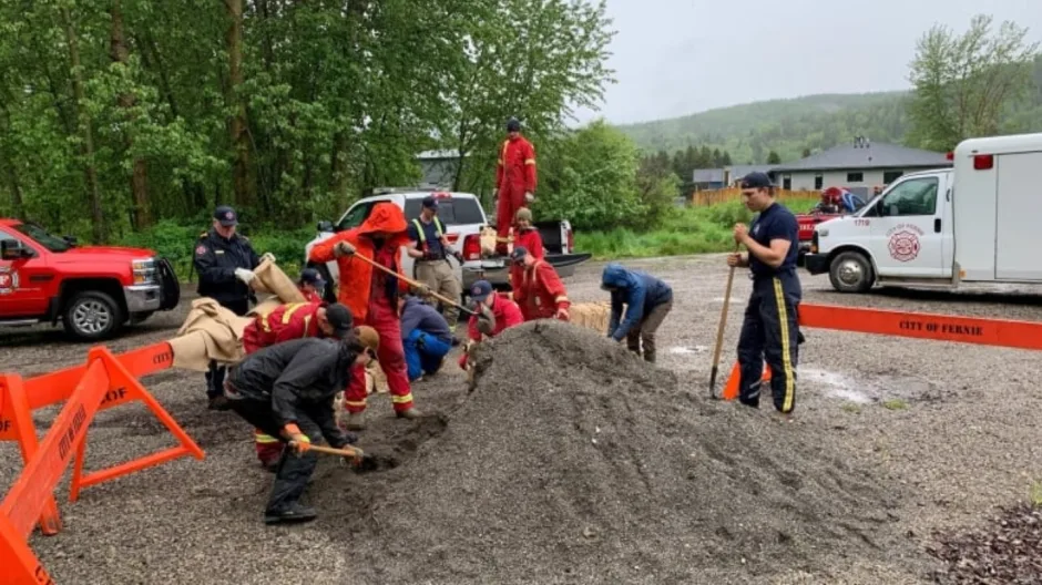
Sandbagging efforts in Fernie, B.C., after a flood warning was issued for the Elk River. (Ange Qualizza/CBC News)
High stream flow advisories are in effect for the Fraser River and several areas of the B.C. Interior.
Environment Canada says rain and snowfall warnings currently remain in effect across southeast B.C., but could lift as the storm moves east.
In Vernon, Regional District North Okanagan has closed sections of the BX Creek trail due to BX Creek swelling past its banks.
This article was originally published for CBC News on June 14, 2022. Contains files from Joel Ballard, The Canadian Press.