Wednesday, July 6th 2022, 6:00 am - A round of photogenic severe thunderstorms hit Alberta and Saskatchewan on Tuesday, bringing large hail and tornado warnings to southern parts of the provinces.
--
It wouldn’t be summer without storms on the Prairies, and folks across Alberta and Saskatchewan saw some beefy storms on Tuesday as an active system rolled through the region.
Several severe thunderstorms popped up across southern and central Alberta on Tuesday afternoon, the result of instability and favourable dynamics as a low-pressure system moved east across the Prairies.
One particularly intense storm prompted tornado warnings north of Calgary, east of Red Deer. Folks west of Alliance had to take shelter on Tuesday afternoon as a severe thunderstorm in the area developed strong rotation.
While there haven’t been any reports of tornado damage from the region, the storm was certainly impressive. The Weather Network’s Kyle Brittain followed the storm as it reached its peak. Brittain documented the storm’s photogenic structure and resulting hail that covered the region.
Strongly rotating wall cloud W of Alliance #abstorm 232PM pic.twitter.com/jUQF974VDW
Strongly rotating wall cloud W of Alliance Kyle Brittain on Twitter: "Strongly rotating wall cloud W of Alliance #abstorm 232PM pic.twitter.com/jUQF974VDW / Twitter" 232PM Kyle Brittain on Twitter: "Strongly rotating wall cloud W of Alliance #abstorm 232PM pic.twitter.com/jUQF974VDW / Twitter"
— Kyle Brittain (@KyleTWN) Kyle Brittain on Twitter: "Strongly rotating wall cloud W of Alliance #abstorm 232PM pic.twitter.com/jUQF974VDW / Twitter"
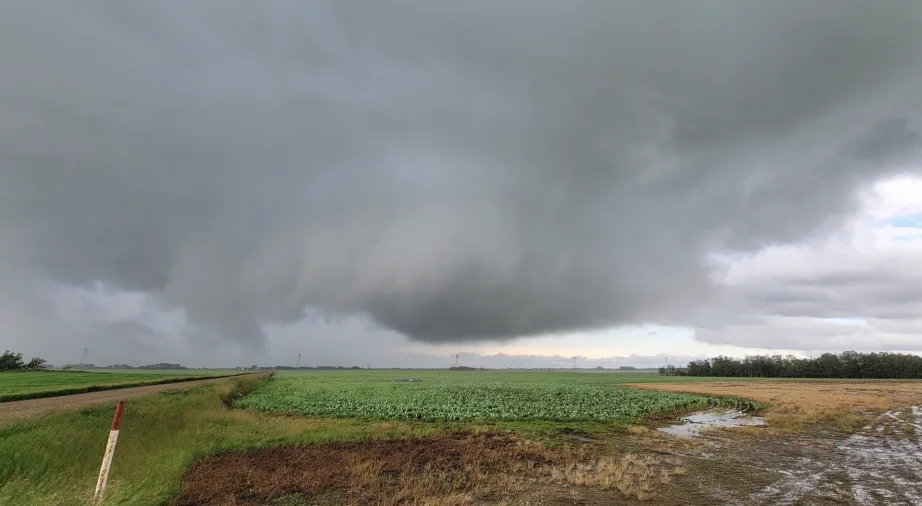
As the storms pushed eastward, a similar eerie scene developed in southern Saskatchewan, where severe thunderstorms produced two confirmed tornadoes.
Environment and Climate Change Canada (ECCC) found that the first tornado touched down west of Madison, while the second tornado touched down about ten minutes later near Smiley.
ECCC said that neither tornado resulted in any reports of damage, so each tornado received received a default EF-0 rating on the Enhanced Fujita Scale.
Funnel near Hoosier #skstorm at 4:47 pm pic.twitter.com/rpr5TzNHhs
Funnel near Hoosier Jenny Hagan LostInSk on Twitter: "Funnel near Hoosier #skstorm at 4:47 pm pic.twitter.com/rpr5TzNHhs / Twitter" at 4:47 pm Jenny Hagan LostInSk on Twitter: "Funnel near Hoosier #skstorm at 4:47 pm pic.twitter.com/rpr5TzNHhs / Twitter"
— Jenny Hagan LostInSk (@LostInSk) Jenny Hagan LostInSk on Twitter: "Funnel near Hoosier #skstorm at 4:47 pm pic.twitter.com/rpr5TzNHhs / Twitter"
Storm chaser Jenny Hagan was following the thunderstorms across Saskatchewan as they moved through the region. She managed to capture a separate tornado-warned storm that would later develop between Madison and Eston:
Tornado warned storm between Madison and Eston #skstorm pic.twitter.com/C4qHRC2bus
Tornado warned storm between Madison and Eston Jenny Hagan LostInSk on Twitter: "Tornado warned storm between Madison and Eston #skstorm pic.twitter.com/C4qHRC2bus / Twitter" Jenny Hagan LostInSk on Twitter: "Tornado warned storm between Madison and Eston #skstorm pic.twitter.com/C4qHRC2bus / Twitter"
— Jenny Hagan LostInSk (@LostInSk) Jenny Hagan LostInSk on Twitter: "Tornado warned storm between Madison and Eston #skstorm pic.twitter.com/C4qHRC2bus / Twitter"
The risk for storms will be largely scattered across the Prairies on Wednesday. The surface trough over Alberta will migrate east towards Saskatchewan and Manitoba, with the focus of scattered storms spreading across the Interlake area of Manitoba. A few cells may develop in far eastern Saskatchewan as well. Follow the latest forecast for more information on what to expect Wednesday.
MUST READ: Everyone needs a home emergency kit. Here’s how to stock yours
Check out some of the impressive visuals that came out of Tuesday’s storms, below.
Hail at TR 372/RR 111. Mainly wet growth with big lobes. #abstorm 335PM @NHP_Reports pic.twitter.com/HLYYkbkkeY
Hail at TR 372/RR 111.
— Kyle Brittain (@KyleTWN) Kyle Brittain on Twitter: "Hail at TR 372/RR 111. Mainly wet growth with big lobes. #abstorm 335PM @NHP_Reports pic.twitter.com/HLYYkbkkeY / Twitter"
Mainly wet growth with big lobes. Kyle Brittain on Twitter: "Hail at TR 372/RR 111. Mainly wet growth with big lobes. #abstorm 335PM @NHP_Reports pic.twitter.com/HLYYkbkkeY / Twitter" 335PM Kyle Brittain on Twitter: "Hail at TR 372/RR 111. Mainly wet growth with big lobes. #abstorm 335PM @NHP_Reports pic.twitter.com/HLYYkbkkeY / Twitter" Kyle Brittain on Twitter: "Hail at TR 372/RR 111. Mainly wet growth with big lobes. #abstorm 335PM @NHP_Reports pic.twitter.com/HLYYkbkkeY / Twitter"
TORNADO west of Alliance #abstorm 238PM pic.twitter.com/i8HyoUL8sS
TORNADO west of Alliance Kyle Brittain on Twitter: "TORNADO west of Alliance #abstorm 238PM pic.twitter.com/i8HyoUL8sS / Twitter" 238PM Kyle Brittain on Twitter: "TORNADO west of Alliance #abstorm 238PM pic.twitter.com/i8HyoUL8sS / Twitter"
— Kyle Brittain (@KyleTWN) Kyle Brittain on Twitter: "TORNADO west of Alliance #abstorm 238PM pic.twitter.com/i8HyoUL8sS / Twitter"
Cold core funnel cloud at Red Deer an hour ago pic taken by Lindsy Mayer #abstorm pic.twitter.com/1VYSsF1NKf
Cold core funnel cloud at Red Deer an hour ago pic taken by Lindsy Mayer Brandon Houck on Twitter: "Cold core funnel cloud at Red Deer an hour ago pic taken by Lindsy Mayer #abstorm pic.twitter.com/1VYSsF1NKf / Twitter" Brandon Houck on Twitter: "Cold core funnel cloud at Red Deer an hour ago pic taken by Lindsy Mayer #abstorm pic.twitter.com/1VYSsF1NKf / Twitter"
— Brandon Houck (@HouckisPokisewx) Brandon Houck on Twitter: "Cold core funnel cloud at Red Deer an hour ago pic taken by Lindsy Mayer #abstorm pic.twitter.com/1VYSsF1NKf / Twitter"
abstorm hyperlapse just N or coronation, ab 3:30PM. pic.twitter.com/jfiO9lQbdR
Tracey Dyck on Twitter: "#abstorm hyperlapse just N or coronation, ab 3:30PM. pic.twitter.com/jfiO9lQbdR / Twitter" hyperlapse just N or coronation, ab 3:30PM. Tracey Dyck on Twitter: "#abstorm hyperlapse just N or coronation, ab 3:30PM. pic.twitter.com/jfiO9lQbdR / Twitter"
— Tracey Dyck (@ABStormChaser) Tracey Dyck on Twitter: "#abstorm hyperlapse just N or coronation, ab 3:30PM. pic.twitter.com/jfiO9lQbdR / Twitter"
Numerous non-supercell funnel clouds in the area east of Three Hills this morning! Have counted four so far. As instability builds, will have to watch for landspouts/hybrids later in the afternoon near the surface low. #abstorm pic.twitter.com/GYcxhYwRtW
Numerous non-supercell funnel clouds in the area east of Three Hills this morning!
— Kyle Brittain (@KyleTWN) Kyle Brittain on Twitter: "Numerous non-supercell funnel clouds in the area east of Three Hills this morning! Have counted four so far. As instability builds, will have to watch for landspouts/hybrids later in the afternoon near the surface low. #abstorm pic.twitter.com/GYcxhYwRtW / Twitter"
Have counted four so far.
As instability builds, will have to watch for landspouts/hybrids later in the afternoon near the surface low. Kyle Brittain on Twitter: "Numerous non-supercell funnel clouds in the area east of Three Hills this morning! Have counted four so far. As instability builds, will have to watch for landspouts/hybrids later in the afternoon near the surface low. #abstorm pic.twitter.com/GYcxhYwRtW / Twitter" Kyle Brittain on Twitter: "Numerous non-supercell funnel clouds in the area east of Three Hills this morning! Have counted four so far. As instability builds, will have to watch for landspouts/hybrids later in the afternoon near the surface low. #abstorm pic.twitter.com/GYcxhYwRtW / Twitter"
Non-supercell funnel cloud east of Three Hills #abstorm 1135AM pic.twitter.com/kpb8kQJpRy
Non-supercell funnel cloud east of Three Hills Kyle Brittain on Twitter: "Non-supercell funnel cloud east of Three Hills #abstorm 1135AM pic.twitter.com/kpb8kQJpRy / Twitter" 1135AM Kyle Brittain on Twitter: "Non-supercell funnel cloud east of Three Hills #abstorm 1135AM pic.twitter.com/kpb8kQJpRy / Twitter"
— Kyle Brittain (@KyleTWN) Kyle Brittain on Twitter: "Non-supercell funnel cloud east of Three Hills #abstorm 1135AM pic.twitter.com/kpb8kQJpRy / Twitter"
Tornado from near Glidden, SK not long ago. It's since lifted. #skstorm 📸Neil Serfus pic.twitter.com/WjZVmvCmHt
Tornado from near Glidden, SK not long ago. It’s since lifted. Prairie Storm Chasers on Twitter: "Tornado from near Glidden, SK not long ago. It's since lifted. #skstorm 📸Neil Serfus pic.twitter.com/WjZVmvCmHt / Twitter"
— Prairie Storm Chasers (@PrairieChasers) Prairie Storm Chasers on Twitter: "Tornado from near Glidden, SK not long ago. It's since lifted. #skstorm 📸Neil Serfus pic.twitter.com/WjZVmvCmHt / Twitter"
📸Neil Serfus Prairie Storm Chasers on Twitter: "Tornado from near Glidden, SK not long ago. It's since lifted. #skstorm 📸Neil Serfus pic.twitter.com/WjZVmvCmHt / Twitter"