Hurricane Ida rapidly intensifying in the Gulf as it heads for Louisiana

Hurricane Ida began to rapidly intensify in the Gulf of Mexico on Saturday as it makes its final approach toward southern Louisiana.
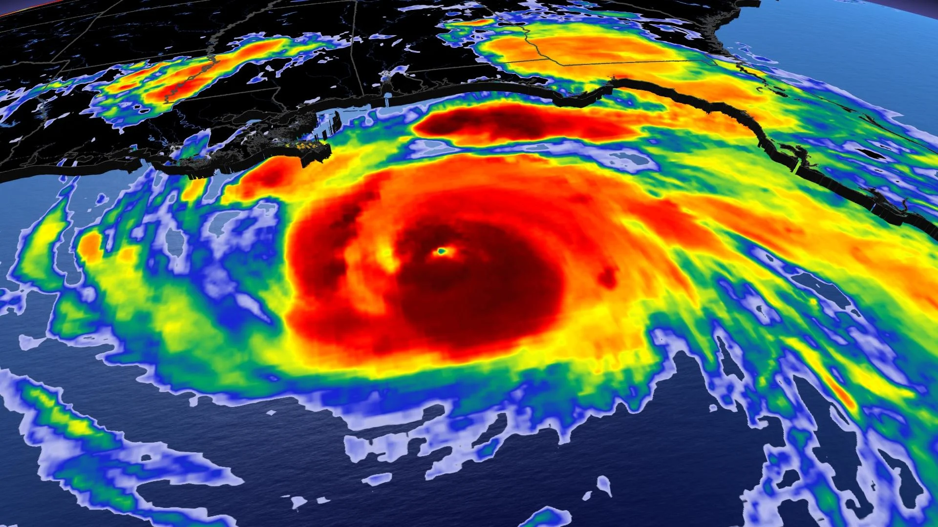
Hurricane Ida began to rapidly intensify in the Gulf of Mexico on Saturday as it steadily made its way toward a Sunday landfall in southern Louisiana. Forecasters at the U.S. National Hurricane Center (NHC) aren’t mincing their words, calling for Ida to be an “extremely dangerous major hurricane” that could produce “potentially catastrophic wind damage” when it comes ashore. More on the storm’s impacts through early next week, below.
HURRICANE IDA NOW A CATEGORY 2 STORM
A favourable environment over the Gulf of Mexico allowed Ida to quickly intensify on Saturday, and all indications are that the storm isn’t done strengthening.
According to the NHC, Hurricane Ida's maximum sustained winds are near 165 km/h, with higher gusts, making the system a Category 2 on the Saffir-Simpson Hurricane Wind Scale.
MUST SEE: A hurricane in Louisiana is a threat that keeps meteorologists awake at night
Rapid strengthening is in the forecast over the next 24 hours and forecasters expect Ida to be an extremely dangerous major hurricane when it approaches the northern Gulf Coast on Sunday. The storm will weaken as it moves inland.

After making landfall southwest of New Orleans, the system and its remnants will track over the southeastern U.S. toward the Mid-Atlantic states through early next week.
LIFE-THREATENING STORM SURGE AND DESTRUCTIVE WINDS EXPECTED
The hurricane is on track to make landfall in southern Louisiana during the day on Sunday. Hurricane Ida’s strong winds, storm surge, flooding rains, and tornadoes will have a wide reach that affects communities far away from the point of landfall.
The NHC’s Saturday evening update warned that the hurricane would bring “life-threatening storm surge, potentially catastrophic wind damage, and flooding rainfall” when it begins to push ashore.

The agency’s latest forecast indicates that the hurricane’s maximum sustained winds could be near 215 km/h at landfall. Strong winds will stretch well inland, potentially leading to widespread damage and power outages across the region.
STAY PREPARED: Hurricane Preparedness: What you need in your kit
A storm surge as deep as 4.5 m above ground level is possible from Morgan City, Louisiana, to the mouth of the Mississippi River if the hurricane makes landfall at high tide. A dangerous and potentially life-threatening storm surge is possible as far west as southwestern Louisiana and as far east as the Alabama/Florida state line.
"The deepest water will occur along the immediate coast near and to the east of the landfall location, where the surge will be accompanied by large and dangerous waves," the NHC warns.
Storm surge is seawater pushed inland by a tropical system’s strong and persistent winds. This kind of flooding is a significant threat to life and property whenever a hurricane makes landfall. The deepest storm surge is likely east of the hurricane’s path as it makes landfall.
Heavy rainfall from Ida will spread over the Louisiana coast Sunday morning, moving northeast into the lower Mississippi Valley later Sunday into Monday. Total rainfall amounts of 200-300 mm, with isolated maximum amounts of 500 mm are possible across southeast Louisiana and southern Mississippi through Monday. This is likely to result in life-threatening flash flooding in urban areas and near waterways.

Ida is forecast to turn northeast later Monday, with rainfall totals of 100-200 mm possible from northeastern Louisiana and central Mississippi into the Tennessee Valley. This is likely to result in widespread flash flooding across the region.
Tornadoes will be possible on Sunday and Monday across the northern Gulf Coast states along and to the east of Ida’s path inland. The longest-duration tornado threat will exist across southeast Louisiana and southern Mississippi.
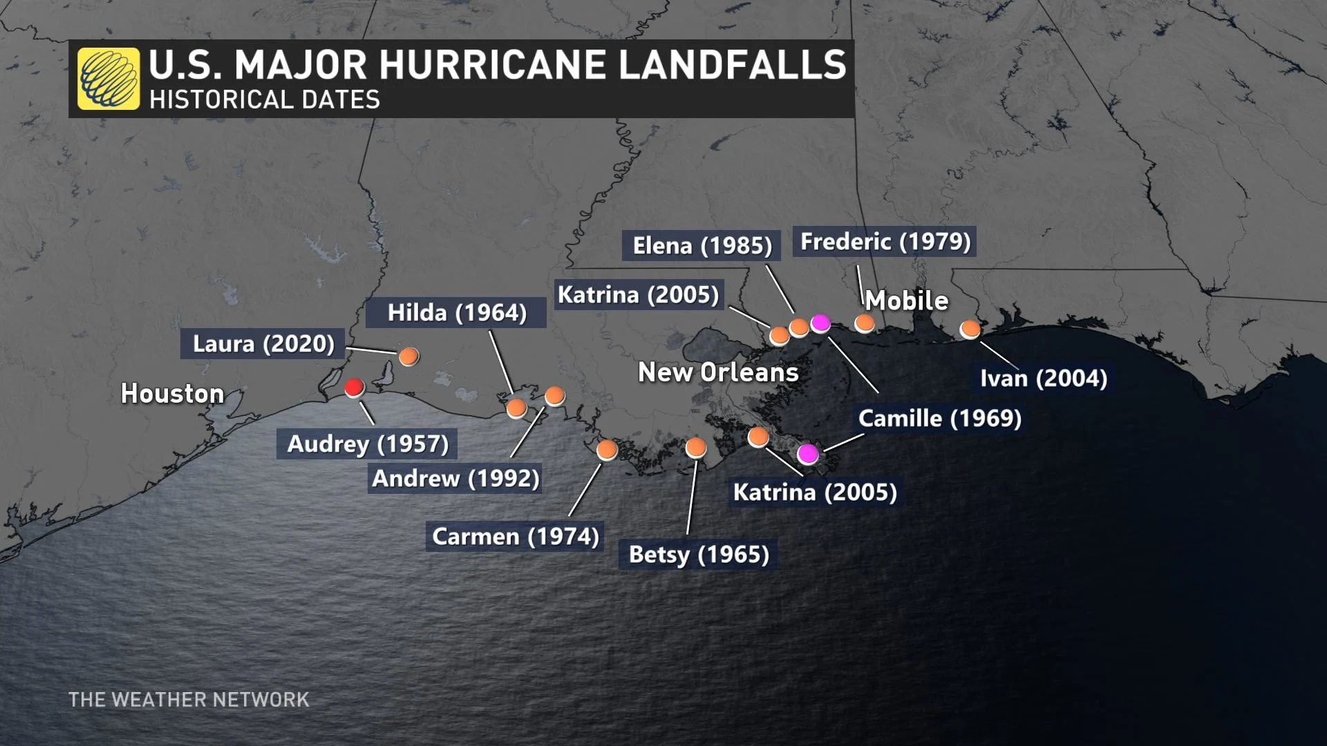
Hurricane Ida is on track to hit the northern Gulf Coast at a sensitive time. Sunday is the 16-year anniversary of Hurricane Katrina’s landfall in Louisiana and Mississippi. The historic storm’s flooding and aftermath killed more than 1,800 people in the area, leaving an indelible mark on the region’s residents.
A LOOK AT THREE HISTORICAL, DEVASTATING U.S. GULF COAST LANDFALLING-HURRICANES
THE GULF COAST IS EXTREMELY VULNERABLE TO STORM SURGE
"This is a potential disaster in the making for the Gulf of Mexico," says Tyler Hamilton, a meteorologist at The Weather Network. "This is a worst-case scenario to get an intensifying hurricane as it approaches the Gulf states," Hamilton added.
The northern Gulf Coast is a vulnerable spot for a strong hurricane to make landfall. The region has a long history of major hurricane landfalls, including Camille in 1969 and Katrina in 2005.
One of the greatest threats from any storm to hit this region is storm surge. The terrain of the Gulf Coast makes this region extremely susceptible to storm surge.
For example, much of Louisiana’s coastline consists of flat swamps, marshes, and beaches. This terrain offers little resistance to a storm surge, allowing seawater to push many kilometres inland from the coast.
The predicted path of the storm is particularly concerning for New Orleans, La. The majority of neighbourhoods there reside at or below sea level, leaving the city prone to flooding from both storm surge and heavy rainfall.
STORM WILL TAX REGION’S MEDICAL RESOURCES AMID SPIKE IN VIRUS CASES
Making matters worse, the southern United States is in the midst of a sharp spike in coronavirus cases. Hundreds of thousands of new cases have been reported across the region in the past few weeks.
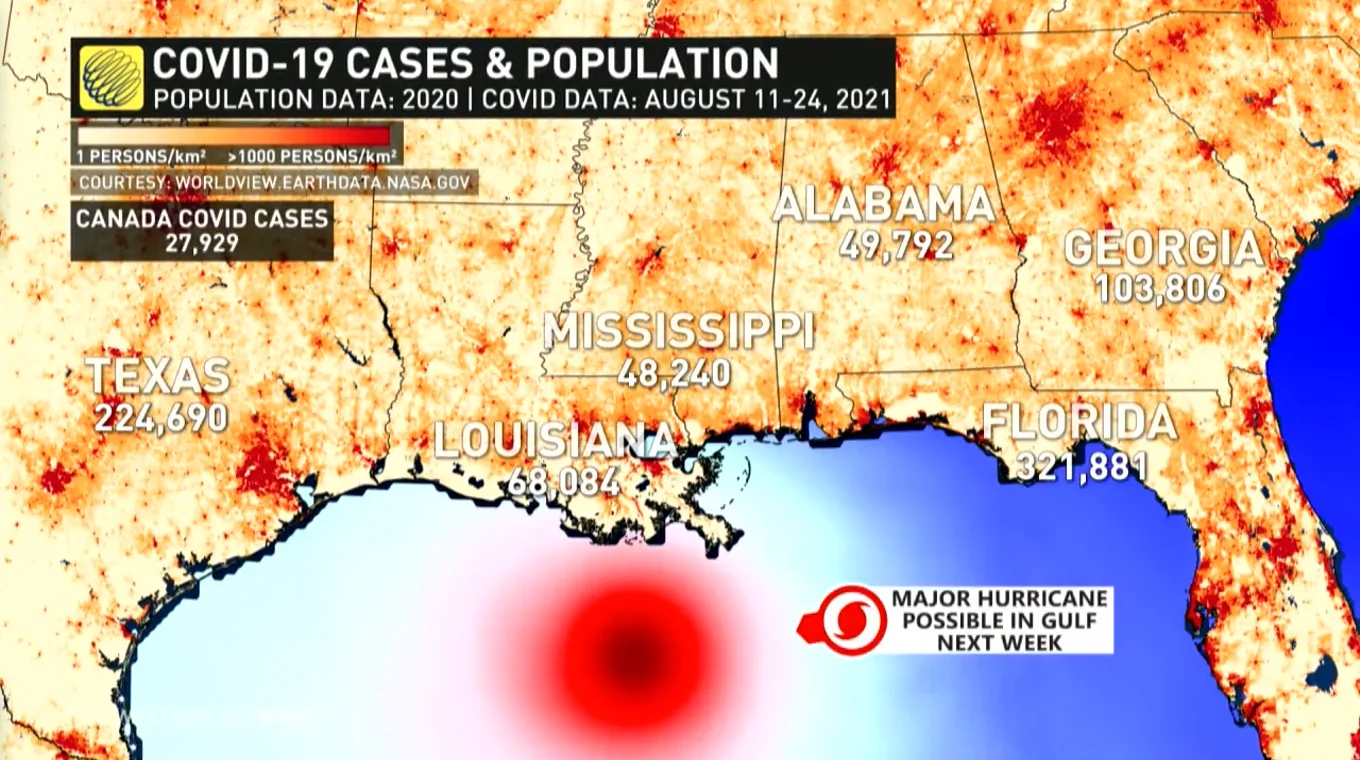
Many hospitals across the southern states are overwhelmed by the influx of coronavirus patients. The New York Times reported last week that there were no intensive care beds left in the entire state of Alabama on August 18, a reflection of the dire situation in this part of the U.S. This storm and its potential aftermath could further stretch medical workers and resources to their limits.
Thumbnail courtesy of NOAA.
Stay tuned to The Weather Network for the latest on Hurricane Ida.