A hurricane in Louisiana is a threat that keeps meteorologists awake at night

Louisiana’s unique terrain and low-lying cities make landfalling hurricanes a harrowing prospect in this part of the southern United States.
Meteorologists have nightmares about a major hurricane barrelling toward the Louisiana coastline. This scenario appears near the top of just about every list of potential weather catastrophes.
Hurricanes are dangerous no matter where they make landfall, but Louisiana’s unique terrain and position on the Gulf Coast makes a strong storm churning toward this part of the southern United States a particularly harrowing prospect.
THE GULF OF MEXICO FUELS SOME OF THE STRONGEST STORMS POSSIBLE
The very location and shape of the northern Gulf Coast leaves this region exceptionally vulnerable to an approaching hurricane.
The Gulf of Mexico holds some of the warmest ocean water in the world. Sea surface temperatures here routinely push 30°C or higher during the heat of the summer. This deep reserve of hot water acts like an incubator for budding tropical cyclones.
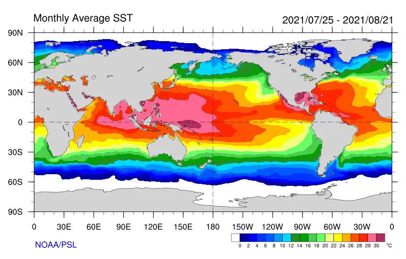
The Gulf of Mexico is home to some of the hottest sea surface temperatures in the world during the peak of the summer. (Map by NOAA/PSL)
Tropical systems moving across the Atlantic Ocean and Caribbean Sea can ramp up in a hurry once they surround themselves with the moist air, calm winds, and bath-like water temperatures commonly found in the Gulf of Mexico.
Once a storm spins up over the Gulf, the horseshoe shape of the coastline surrounding the basin essentially guarantees a landfall, forcing a storm to traverse the basin’s steamy waters until it finally reaches the shore.
LOUISIANA IS A FREQUENT BULLSEYE FOR STORMS ENTERING THE GULF
Louisiana’s position on the northern Gulf Coast leaves the state directly in the path of many tropical storms and hurricanes that enter the Gulf of Mexico.
During the height of the summer, prevailing winds over the basin often curve around a centre of high pressure in the western Atlantic commonly called the Bermuda High.
This high can act like a barrier that prevents tropical systems from simply curving out to sea. The strength and position of the Bermuda High usually dictates the path of storms as they enter the Gulf and begin to curve toward land.
Sometimes, the ridge of high pressure is strong enough that it forces a storm to track straight across the Gulf into Mexico or Texas. Other storms can take advantage of a weakness in the ridge and curve to hit Florida. But the high is often in just the right spot that it guides storms along a gentle curve straight into southern Louisiana.
LOUISIANA’S LOW ELEVATION MAKES FLOODING A MAJOR ISSUE
The vast majority of Louisiana’s coastline consists of marshes, swamps, and beaches. Many communities near the coast lie at sea level or just a few metres higher, providing little protection from storm surge flooding during a landfalling tropical storm or hurricane.
Storm surge is seawater pushed inland by a hurricane’s strong winds. The effects of storm surge depend on lots of variables, such as the size, strength, and duration of a storm, the shape of the coastline, the terrain near the coast, and whether communities have built barriers or levees to keep the water out.
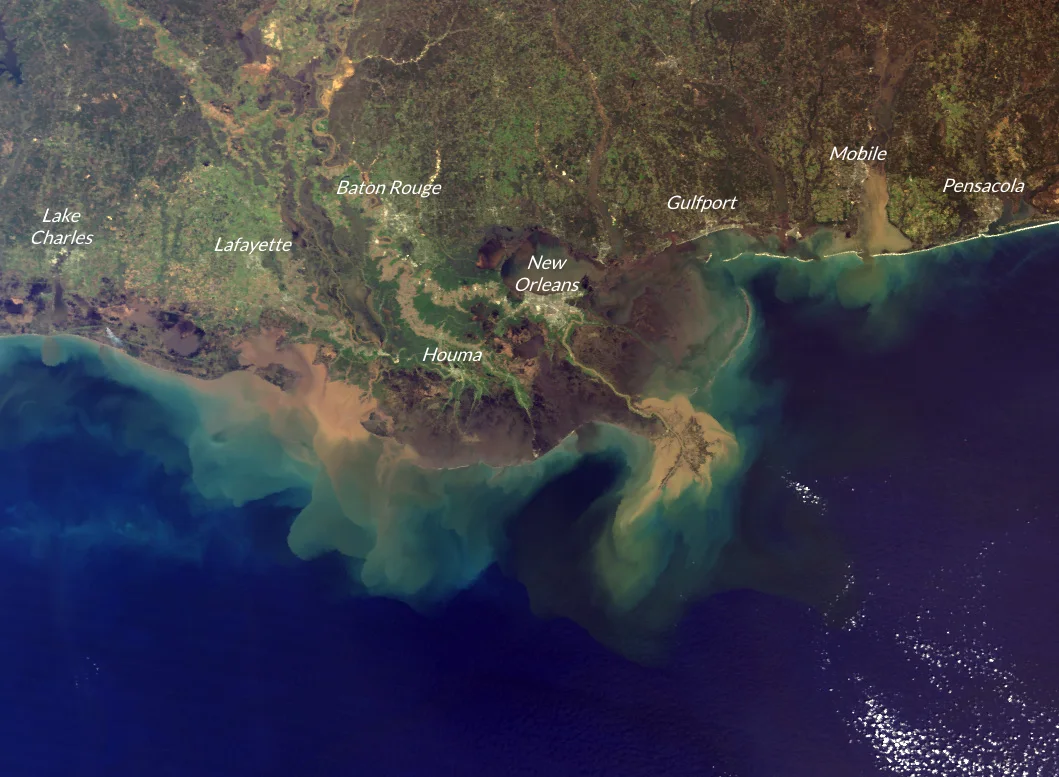
A satellite image of the northern Gulf Coast in March 2001. (Image by NASA MODIS/Terra, with annotations by the author.)
Louisiana’s flat, swampy coastline provides little resistance to a landfalling storm. The strongest hurricanes can generate a storm surge that rises more than 4 m above ground level, which can easily inundate homes and businesses both near the coast and many kilometres inland.
One extreme example of the state’s vulnerability to flooding occurred during Hurricane Laura in 2020, when forecasters warned that the category 4 hurricane’s storm surge could push more than 60 km inland across the swamps and waterways of southwestern Louisiana.
Tropical downpours can lead to widespread flash flooding far inland from the coast. A tropical system’s prolific rains can easily overwhelm Louisiana’s numerous waterways. Hundreds of millimetres of rain falling in a short period of time can lead to flash flood emergencies across the state, often requiring rescue crews to perform water rescues for people trapped in vehicles and homes.
MUCH OF NEW ORLEANS SITS BELOW SEA LEVEL
Few major cities at risk for hurricanes struggle with water as much as New Orleans. Bounded by Lake Pontchartrain to the north and the Mississippi River to the south, much of New Orleans sits at or below sea level. This low elevation forces residents to rely on a system of levees to keep the water out and pumps to drain rainwater away from the city.
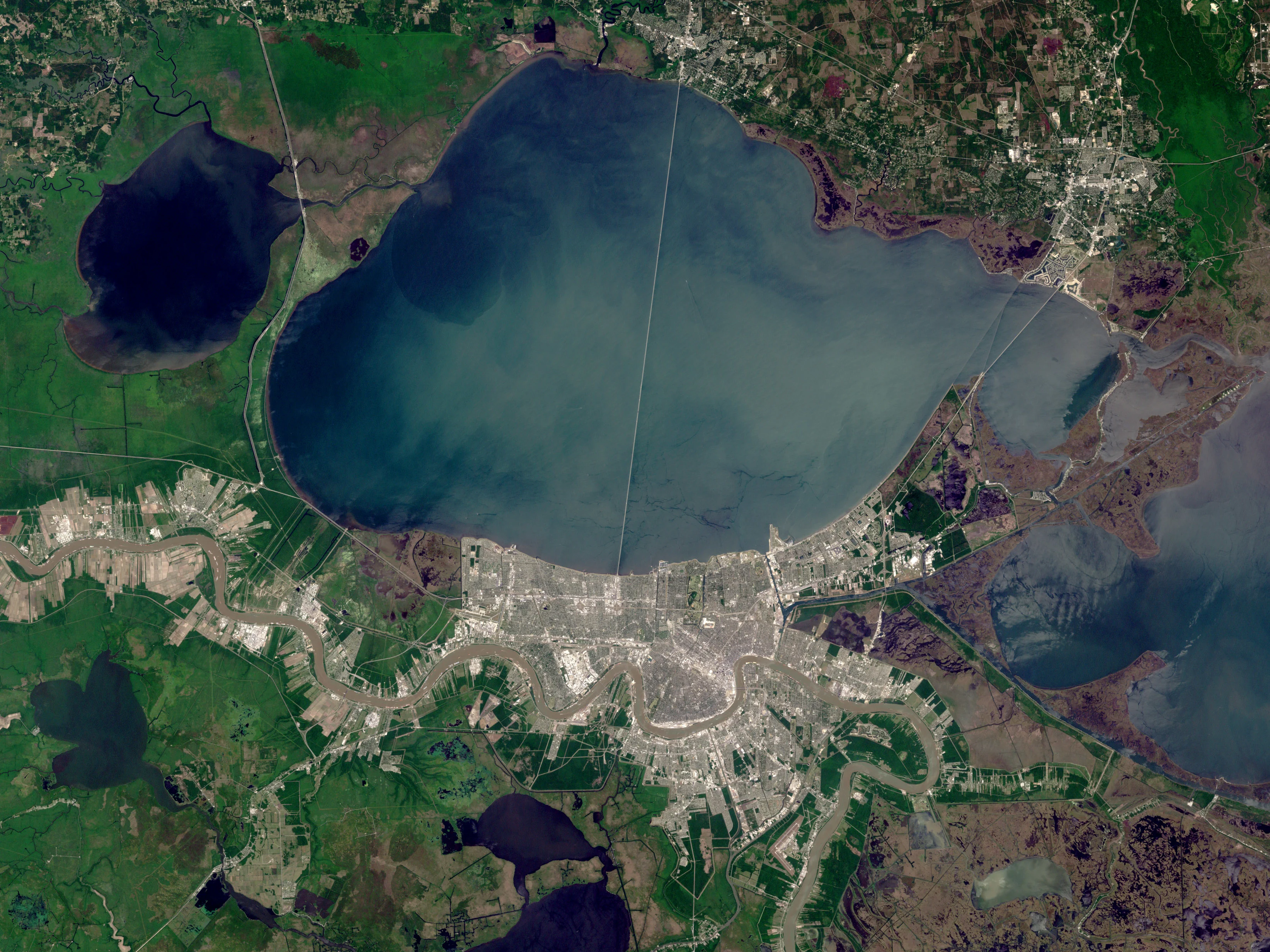
A satellite image of New Orleans, Louisiana, taken by Landsat 7, showing Lake Pontchartrain to the north and the Mississippi River to the city's south. (Image by NASA/USGS)
The city’s levee system failed under the stress of Hurricane Katrina’s storm surge in August 2005, flooding 80 per cent of the city.
Officials rebuilt and strengthened New Orleans’ levee system after Katrina. The network is designed to “withstand an event roughly equivalent to a typical category 3 hurricane,” according to the city’s website.
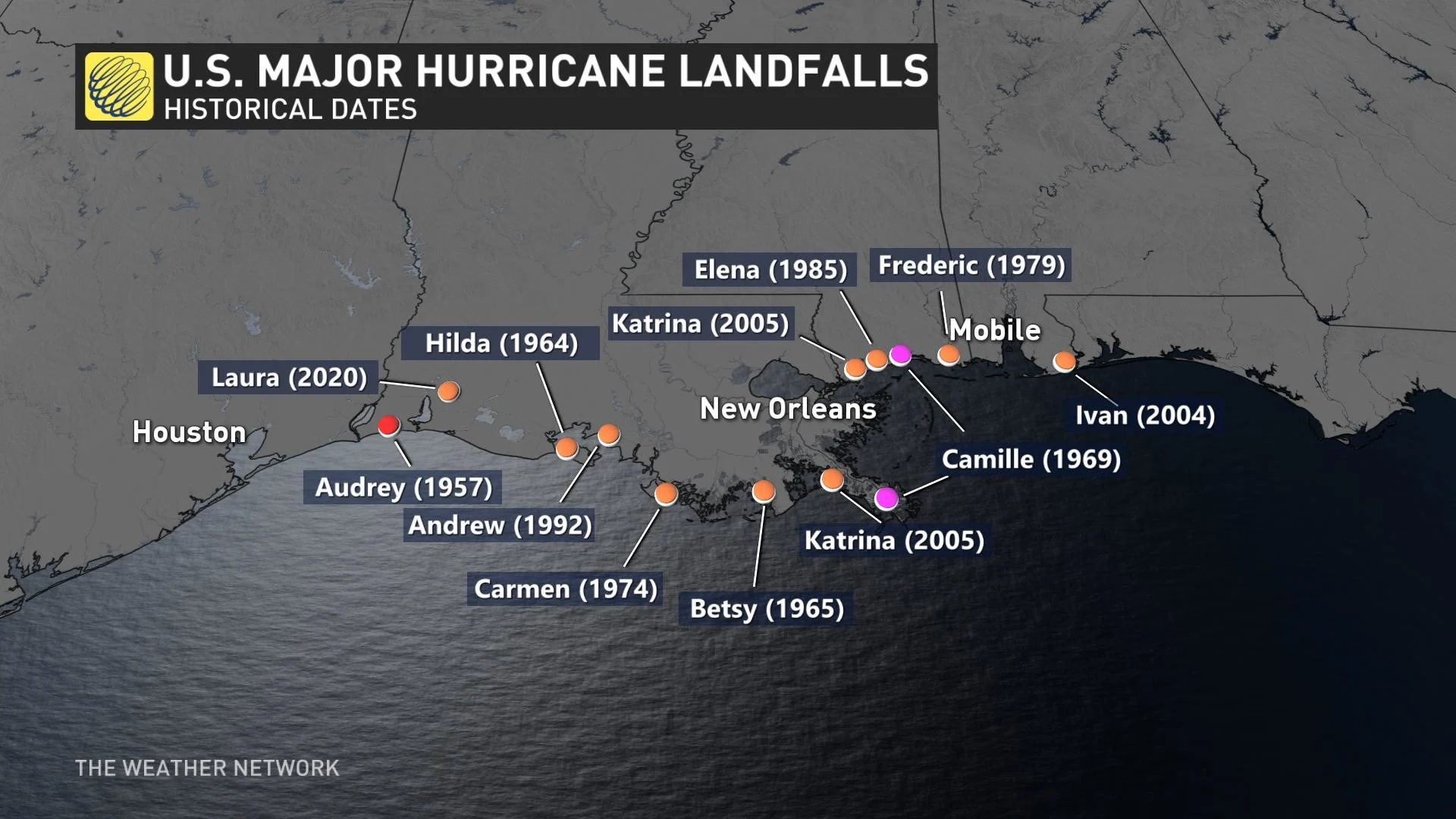
SOME OF HISTORY’S WORST STORMS HIT LOUISIANA
Louisiana’s unique vulnerability allows each major storm that hits the region to carve out its own spot in weather history.
Two of the most impactful storms to hit Louisiana in the past few decades were Hurricane Katrina in 2005 and Hurricane Laura in 2020. Both storms were high-end disasters for the region, but for very different reasons.
Hurricane Katrina intensified into a scale-topping category 5 hurricane when it emerged over the Gulf of Mexico in late August 2005. The system’s raw power was matched by its incredible size, at one point spanning hundreds of kilometres from one end of the storm to the other.
Katrina lost some strength and made landfall in Louisiana and Mississippi as a major category 3 hurricane, but the impacts were locked in.
The storm’s sheer size, combined with its intensity just hours before landfall, generated an enormous storm surge that devastated communities in parts of Louisiana, Mississippi, and Alabama. More than 1,800 people died during the storm and its immediate aftermath.
WATCH NOW: DRAMATIC BEFORE AND AFTER SHOWS DEVASTATING HURRICANE LAURA IMPACT
Hurricane Laura rapidly intensified into a category 4 hurricane as it marched across the Gulf of Mexico in late August 2020. The hurricane gathered strength all the way until its eye passed over Lake Charles, Louisiana, in the southwestern corner of the state.
The hurricane jumped from a tropical storm to the verge of category 5 intensity in about 36 hours, a testament to the potential Gulf storms can tap into when they encounter favourable conditions.
While Laura wasn’t nearly as large of a hurricane as Katrina, its strongest winds crossed over an area that's home to nearly a quarter of a million people, leaving behind tremendous damage in its wake.
Hurricane Laura even destroyed the weather radar at the U.S. National Weather Service’s office in Lake Charles, one of only a few radar sites lost in the agency’s history of observing ferocious storms across the country.
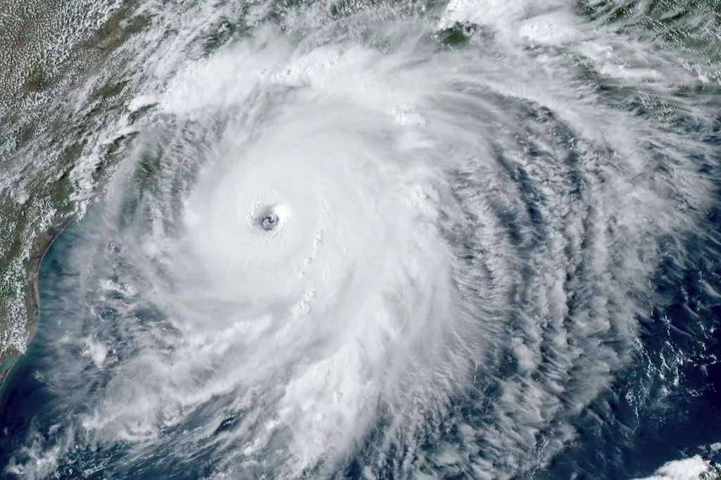
Thumbnail of Hurricane Laura courtesy of NOAA.