Hurricane Ida lashes Gulf Coast with intense winds as it pushes inland

Hurricane Ida will steadily weaken as it tracks across Louisiana and Mississippi through Monday. The storm made landfall southwest of New Orleans as a high-end category 4 storm.
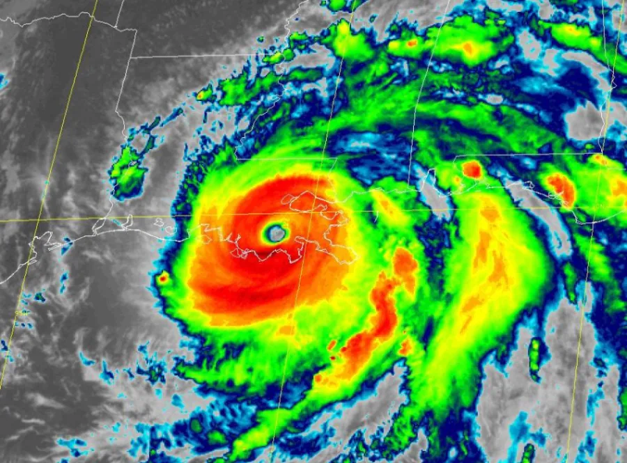
Hurricane Ida roared ashore along the northern Gulf Coast on Sunday afternoon as an extremely dangerous, high-end category 4 hurricane. The storm made landfall in southeastern Louisiana with 240 km/h winds, producing widespread damage and a life-threatening storm surge. The storm will continue pushing into the southeastern United States over the next couple of days. More on the storm’s impacts through the week, below.
IDA MADE LANDFALL AS AN EXTREMELY DANGEROUS CATEGORY 4 HURRICANE
Hurricane Ida rapidly intensified over the Gulf of Mexico overnight Saturday into Sunday as it made its final approach into southeastern Louisiana. The system grew into a high-end category 4 storm with maximum sustained winds of 240 km/h before landfall.
The storm made two landfalls in southeastern Louisiana on Sunday afternoon, bringing destructive winds, a life-threatening storm surge, flooding rains, and tornadoes to one of the most vulnerable stretches of coastline in the United States.
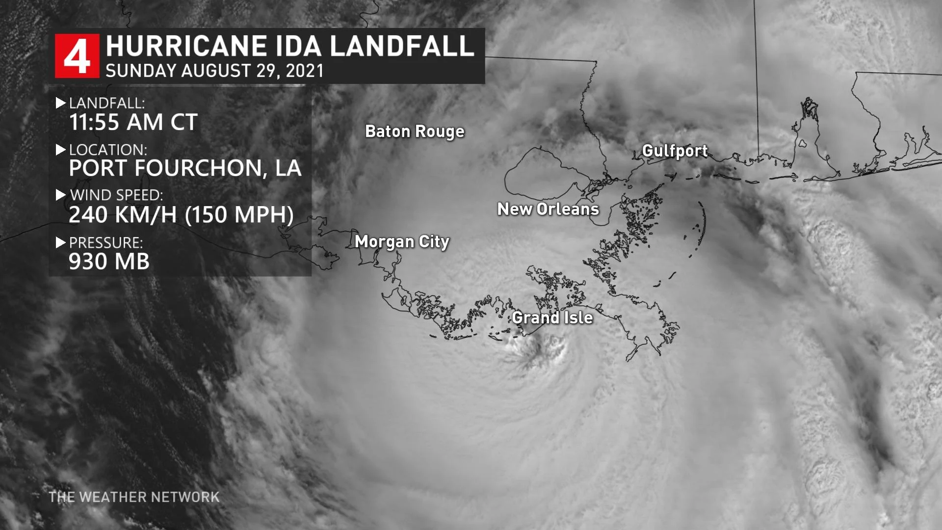
Ida first came ashore around 11:55 a.m. CDT near Port Fourchon, La., with maximum sustained winds of 240 km/h and a minimum central pressure of 930 mb, according to the U.S. National Hurricane Center (NHC).
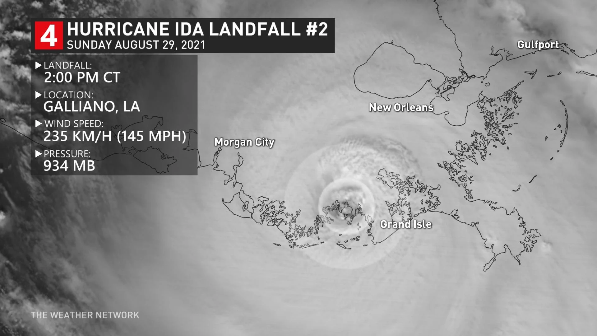
Ida made a second landfall a few hours later in Galliano, La., with maximum sustained winds of 235 km/h and a minimum central pressure of 934 mb.
An observing station in Galliano recorded a wind gust of nearly 200 km/h around 3:30 p.m. CDT as the hurricane’s eyewall passed overhead, according to a tweet from the U.S. National Weather Service (NWS) office in New Orleans.
The hurricane didn’t immediately weaken after landfall. The warm water and low friction of Louisiana's swamps and marshes can help a hurricane maintain its composure. Hurricane Ida took advantage of this favourable environment to maintain major hurricane status for more than eight hours after landfall.
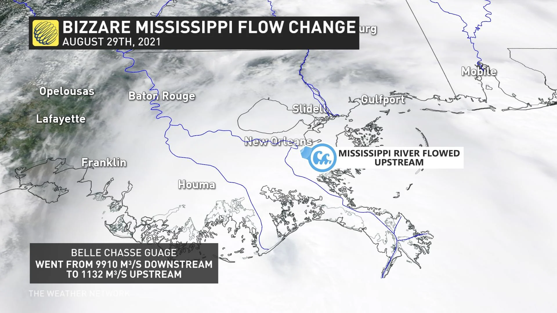
The hurricane's storm surge reversed the flow of the Mississippi River at one point on Sunday afternoon. A United States Geological Survey (USGS) sensor in Belle Chasse, La., recorded a negative river flow as the storm pushed ashore, indicating that the Mississippi River began flowing upstream.
A weather station in Lockport, La., reported a minimum pressure of 941.3 mb around 5:00 p.m. CDT as Hurricane Ida's eye moved overhead.
New Orleans International Airport saw 100 km/h sustained winds with a gust to 133 km/h shortly before 6:00 p.m. CDT, when the airport’s anemometer stopped reporting data. Winds grew stronger in New Orleans as the evening wore on and the eyewall drew closer.
The city’s government reported on Twitter that all of New Orleans had lost power by sunset on Sunday due to “catastrophic transmission damage.” Dangerous weather conditions will continue in the city through Monday morning.
MUST SEE: A hurricane in Louisiana is a threat that keeps meteorologists awake at night
Ida will continue to track over southern Louisiana through Sunday night into Monday. The storm will then move into Mississippi before picking up speed and curving to the east as it gets swept up by the same cold front that will bring lower humidity to southern Ontario this week.
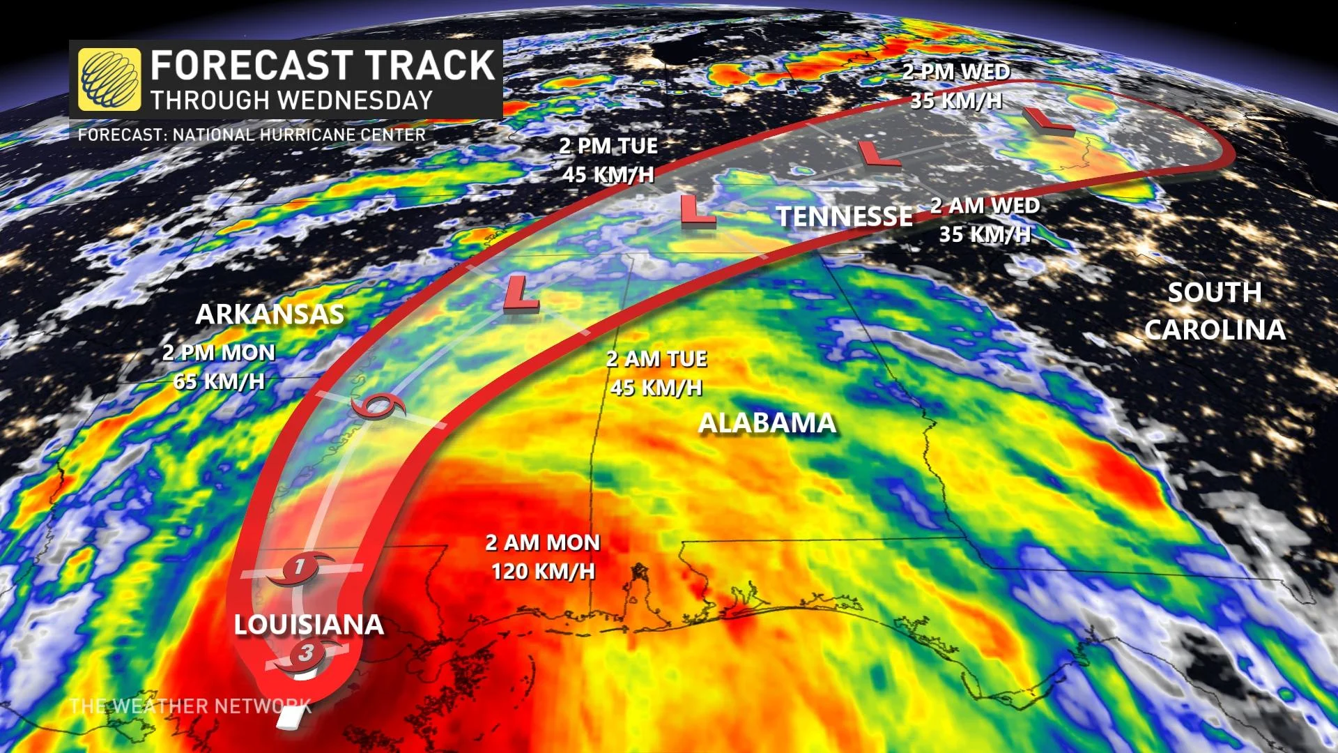
The latest forecast from the NHC shows the storm’s remnants moving over the Mid-Atlantic and Northeast states through the end of the week.
Hurricane Ida’s remnants could influence the weather in the Maritimes by the end of the week or next weekend, but the situation is too fluid right now to know for sure. Check back throughout the week for the latest forecast.
DAMAGING WINDS AND FLOODING RAINS LIKELY AS IDA PUSHES INLAND
Hurricane Ida’s strong winds, flooding rains, and tornadoes will have a wide reach that affects communities far away from southeastern Louisiana.
The storm’s life-threatening storm surge will begin to recede as the system continues inland and winds shift around and blow offshore. We’ll know more about the surge’s depth and effects in the coming days as reports filter out of the region.
Storm surge is seawater pushed inland by a tropical system’s strong and persistent winds. This kind of flooding is a significant threat to life and property whenever a hurricane makes landfall. The deepest storm surge is likely east of the hurricane’s path as it makes landfall.
Strong winds will stretch well inland, potentially leading to widespread damage and power outages across the region.
STAY PREPARED: Hurricane Preparedness: What you need in your kit
Heavy rainfall will follow Ida’s track inland.
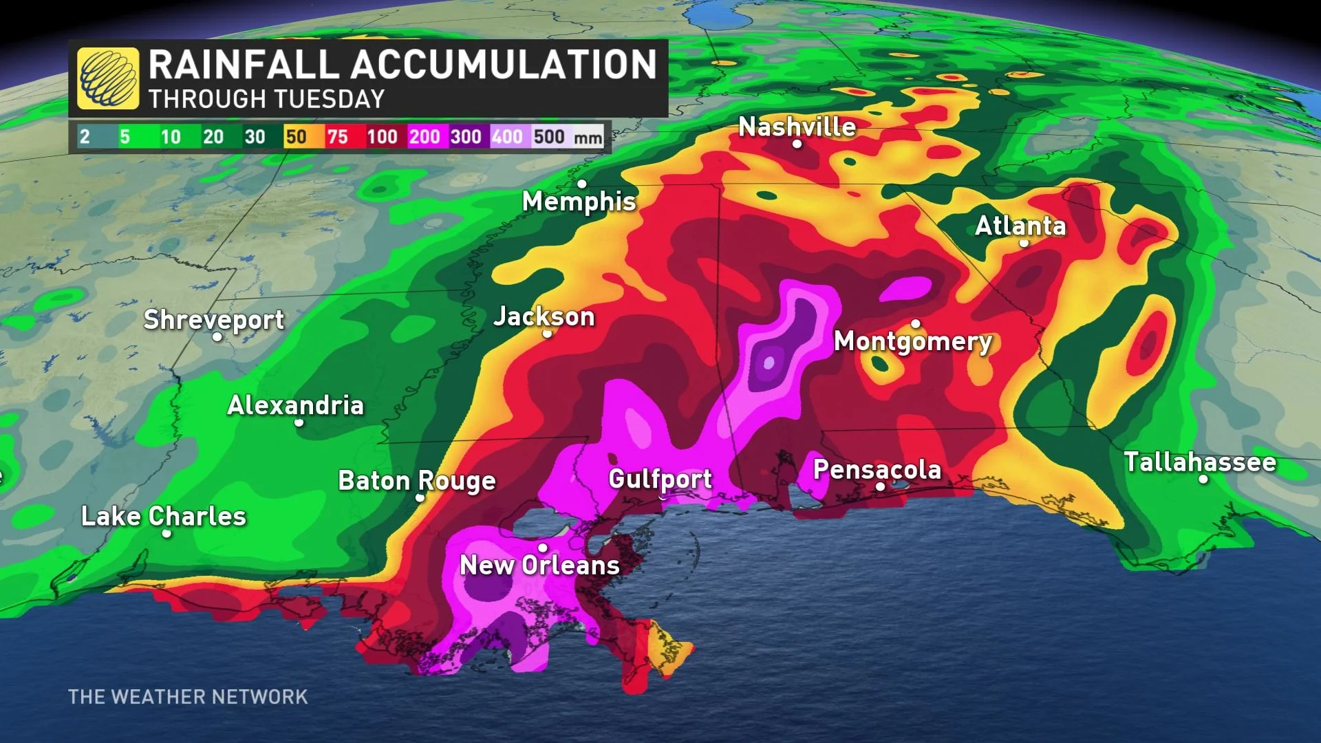
Total rainfall amounts of 250-450 mm, with isolated maximum amounts of 600 mm, are possible across southeast Louisiana and far southern Mississippi through Monday. Rainfall totals of 100-200 mm will be possible throughout much of Alabama, with 50-100 mm common toward the Ohio Valley and the Mid-Atlantic states.
Tornadoes are always a threat when hurricanes make landfall because of the strong wind shear on the eastern side of these storms. Tornadoes will be most likely through Monday over southeast Louisiana, southern Mississippi, southwest Alabama, and the western Florida Panhandle. A few tornadoes are also possible farther north across much of Mississippi and Alabama on Monday.
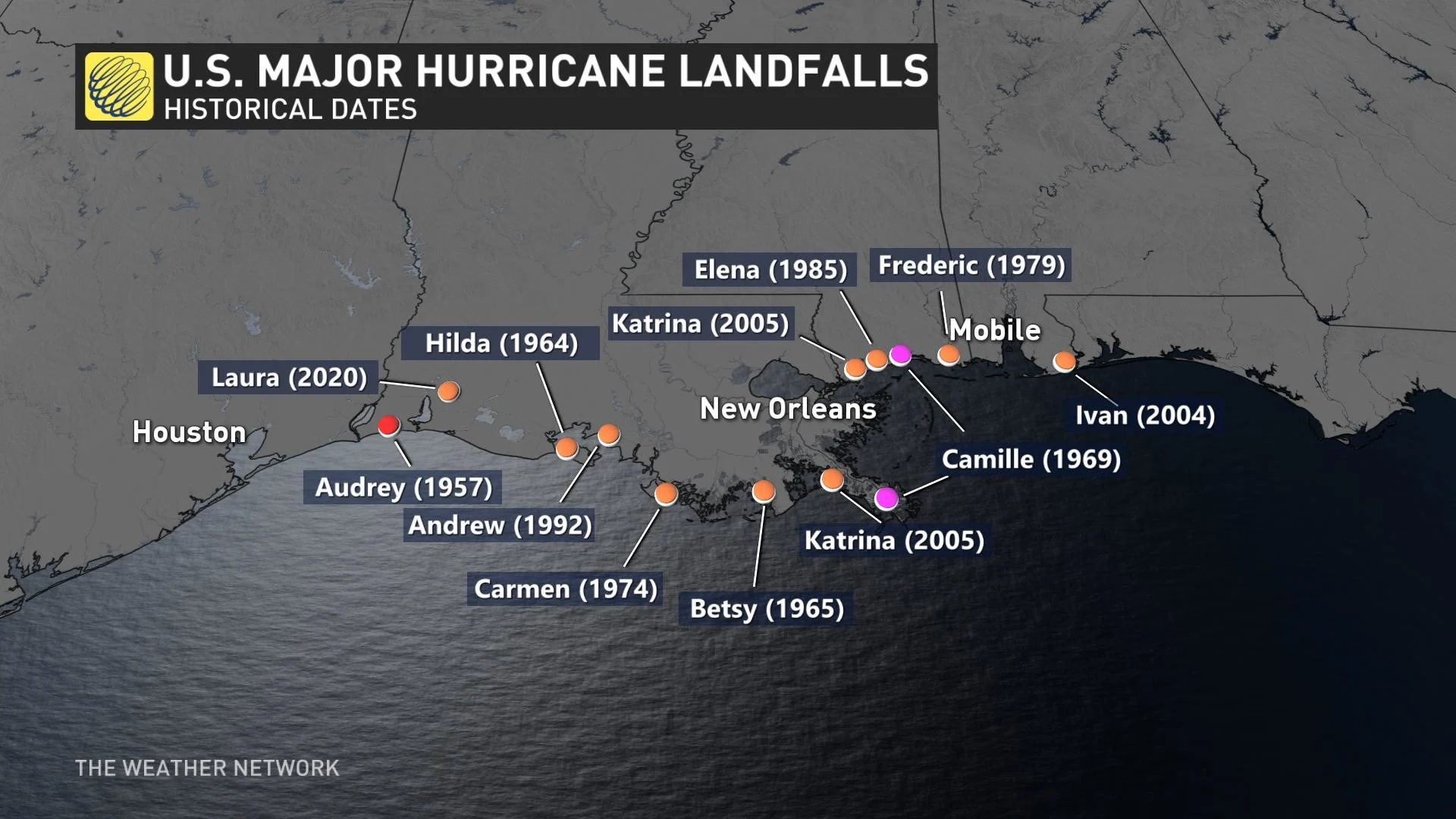
Hurricane Ida hit the northern Gulf Coast at a sensitive time. Sunday was the 16-year anniversary of Hurricane Katrina’s landfall in Louisiana and Mississippi. The historic storm’s flooding and aftermath killed more than 1,800 people in the area, leaving an indelible mark on the region’s residents.
A LOOK AT THREE HISTORICAL, DEVASTATING U.S. GULF COAST LANDFALLING-HURRICANES
THE GULF COAST IS EXTREMELY VULNERABLE TO STORM SURGE
The northern Gulf Coast is a vulnerable spot for a strong hurricane to make landfall. The region has a long history of major hurricane landfalls, including Camille in 1969 and Katrina in 2005.
One of the greatest threats from any storm to hit this region is storm surge. The terrain of the Gulf Coast makes this region extremely susceptible to storm surge.
For example, much of Louisiana’s coastline consists of flat swamps, marshes, and beaches. This terrain offers little resistance to a storm surge, allowing seawater to push many kilometres inland from the coast.
The path of the storm left New Orleans, La., in a bad position on Sunday. The majority of neighbourhoods there reside at or below sea level, leaving the city prone to flooding from both storm surge and heavy rainfall.
STORM WILL TAX REGION’S MEDICAL RESOURCES AMID SPIKE IN VIRUS CASES
Making matters worse, the southern United States is in the midst of a sharp spike in coronavirus cases. Hundreds of thousands of new cases have been reported across the region in the past few weeks.
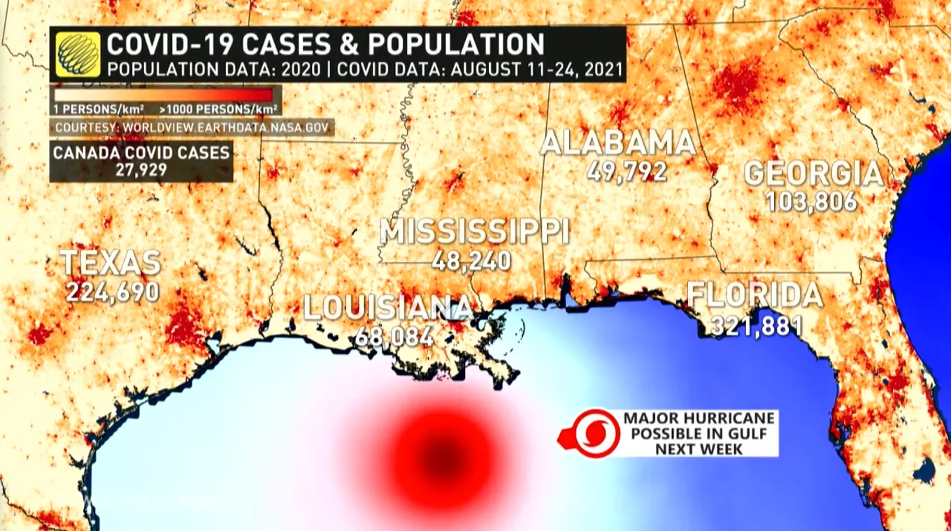
Many hospitals across the southern states are overwhelmed by the influx of coronavirus patients. The New York Times reported last week that there were no intensive care beds left in the entire state of Alabama on August 18, a reflection of the dire situation in this part of the U.S. This storm and its potential aftermath could further stretch medical workers and resources to their limits.
Thumbnail courtesy of NOAA.
Stay tuned to The Weather Network for the latest on Hurricane Ida.