Developing: Tracking two powerful tropical systems impacting Canada

Atlantic Canada's peak hurricane season is September through October. These are the two current systems that could impact the region.
With the development of Tropical Storm Wilfred, we've now exhausted the list of Atlantic hurricane names and will need to tap into the Greek alphabet for the rest of the season. Though the United States has experienced its fair share of tropical impacts, including most recently Sally making landfall in Alabama, Atlantic Canada has been spared...until now, that is.
September typically sees tropical activity pick up for Atlantic Canada, continuing to be under the threat through October. Post-Tropical Depression Sally and Hurricane Teddy are both likely to have an impact on Atlantic Canada, see below for the latest forecast.
TIPS FOR ATLANTIC CANADIANS TO PREPARE FOR HURRICANE TEDDY IMPACTS
MONITOR WEATHER ADVISORIES ON OUR ALERTS PAGE
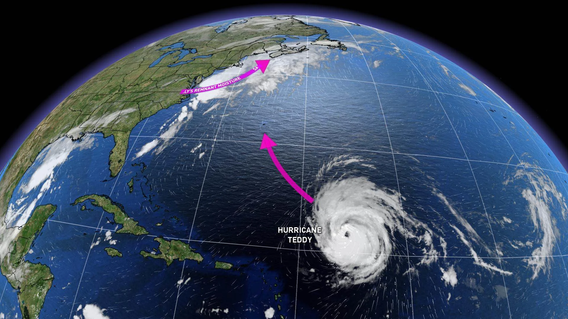
HEAVY RAINFALL FROM SALLY REMNANTS
Remnant moisture from what is now a post-tropical depression, Sally is currently making its way into Atlantic Canada.
A cold front trekking in will funnel in remnant moisture from the former hurricane, leading to subsantial amounts of rainfall for southeastern Newfoundland. Through Saturday, some areas are looking at totals of 50-75mm, including parts of the Avalon. St. John's may receive 30-50 mm of rain.
"Systems that tap into tropical moisture are notorious for overachievement. There is still uncertainty as to exactly where the heaviest rain will fall, so a model blend smooths out the fact that most models have higher totals," says Weather Network meteorologist Dr. Doug Gillham.
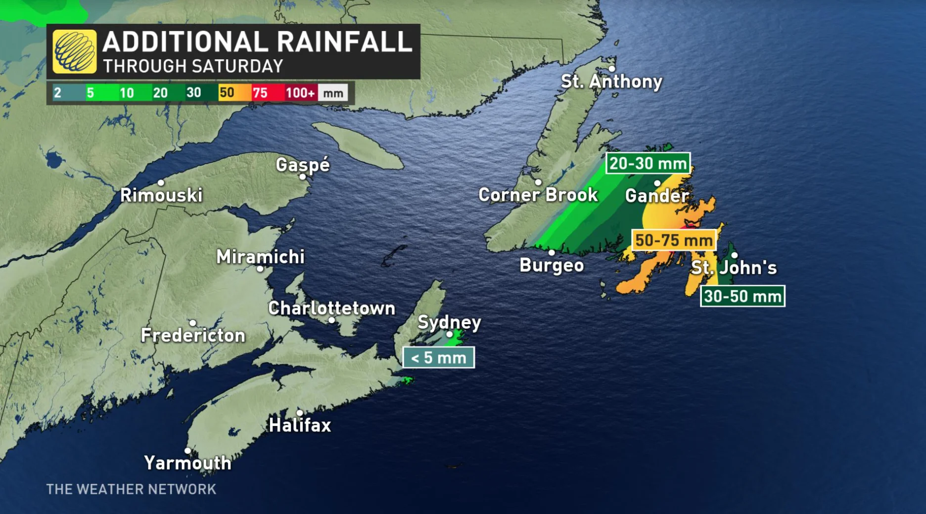
The heaviest rain in Newfoundland will occur Saturday morning, which will be accompanied by very strong winds. Gusts of 90-100 km/h are expected for parts of the Avalon, but will then drop down to 60 km/h in the afternoon, when winds will shift to a northwesterly direction in behind the front. Rain will also taper off during this time.
Environment Canada has issued rainfall warnings across Newfoundland.
“Anyone who is planning to travel west during today or Saturday is advised to check the forecast for the regions of their travels, as rainfall amounts exceeding 100 mm are forecast for the isthmus and areas just west of the Avalon,” Environment Canada says.
“Highway travel may be hazardous or not possible. Heavy downpours can cause flash floods and water pooling on roads. Watch for possible washouts near rivers, creeks and culverts.”
Residents are advised to monitor weather statements, here.
HURRICANE TEDDY PROJECTIONS
Hurricane Teddy is currently churning southeast of Bermuda as a major hurricane, currently a Category 4.
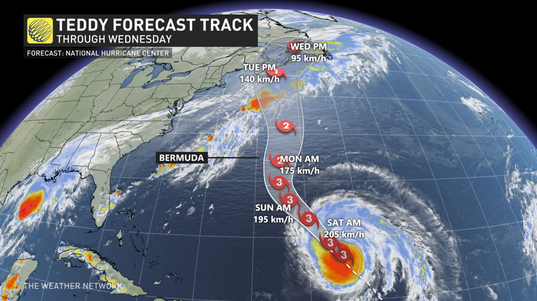
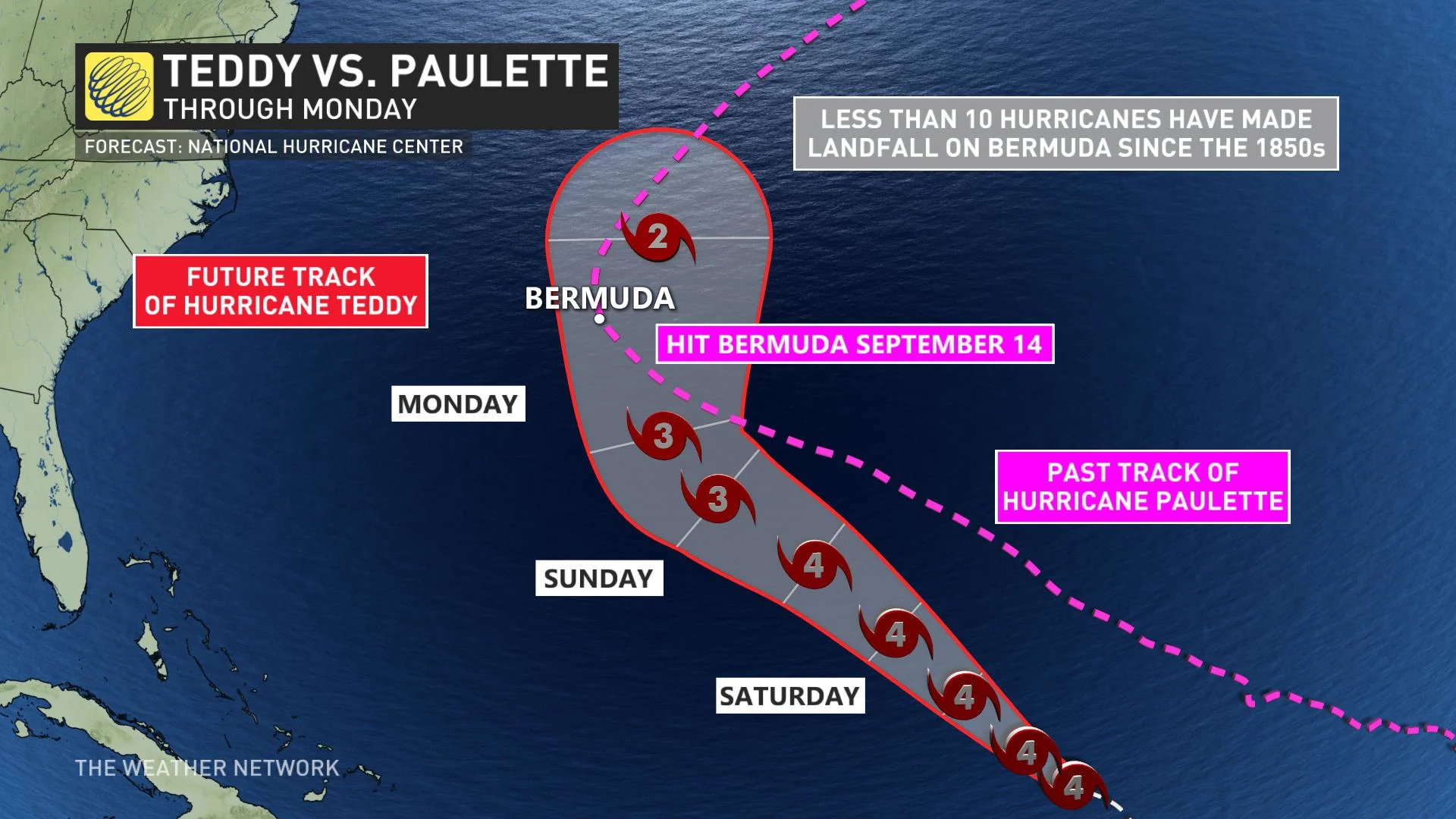
Teddy will approach Bermuda through the weekend, on a track similar to Hurricane Paulette, which made direct landfall less than a week ago. The current forecast track from the National Hurricane Center (NHC) has Teddy approaching Bermuda late Sunday night or Monday morning.
This is a difficult task, since the target of Bermuda is incredibly small compared to the vastness of the Atlantic Ocean. Since the 1850s, less than 10 hurricanes have made direct landfall on the island, according to the NHC.
RELATED: What you need in your hurricane preparedness kit
Following the weekend track, the question then is "where does Teddy go next?"
The highly likely scenario is Teddy tracking into Nova Scotia as possibly a Category 1 hurricane, by Tuesday night or Wednesday morning. The second scenario would keep Teddy offshore with only minor impacts on Atlantic Canada.
WATCH BELOW: MARITIME IMPACT WITH SCENARIO 1
Confidence is much higher in the first scenario playing out. The major models, NHC and the Canadian Hurricane Centre (CHC) have all indicated a track into Nova Scotia. The uncertainty lies in which part of the province will see the landfall, a projection that includes impacts on Halifax.
"Minor differences in the track will be critical for Halifax - much like we were looking at last year with Dorian. If the track is just west of Halifax, then we will see a much more serious impact to Halifax with damaging winds. But if the track is just east of Halifax, then the city will be spared the strongest winds," says Gillham.
"At this point, the biggest question is which part of Nova Scotia will see the damaging winds? Widespread power outages are increasingly likely for parts of Nova Scotia, but the question is which part? And will that include Halifax?"
While a track further to the east into Newfoundland can't be completely ruled out, that scenario looks highly unlikely now.
WATCH BELOW: HURRICANE TEDDY FORECAST UPDATE
The last landfalling tropical system in Atlantic Canada was Dorian, which made landfall in Nova Scotia as a Category 1-equivalent extratropical storm on September 7th, and later on made a second landfall in Newfoundland.
As the situation has the potential to be impactful, continue to check back for updates as we keep an eye on Teddy's movements.