Ontario: Warnings issued as strong storms blossom

Strong to severe storms are rolling through southern Ontario.
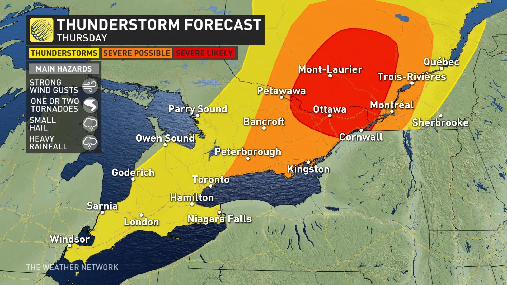
A strong thunderstorm threat takes aim at parts of southern Ontario on Thursday as a cold front looks to put an abrupt end to the week's rising heat and humidity. While isolated showers and thunderstorms are likely to dot much of the region through the day, the highest risk for severe weather -- including large hail and potential tornadoes -- lies over eastern Ontario, including the city of Ottawa. More on the timing of the next round of showers and thunderstorms, plus a look at a heat wave locking in for next week, below.
Summer revealed! Visit our Complete Guide to Summer 2019 for an in-depth look at the Summer Forecast, tips to plan for it and much more
WEATHER HIGHLIGHTS:
Severe thunderstorm watches, warnings issued; latest for your area HERE
Strong isolated storms expected through evening
Highest risk for eastern Ontario, including Ottawa; hail, tornadoes possible
Scattered intense downpours expected Cornwall to London
WATCH BELOW: TRACKING STORMS THROUGH THURSDAY
STRONG STORMS THREATEN THURSDAY
The day started with a rainshower for many across southern Ontario as the leftovers from Wednesday's overnight storms swept southeastward, but it's the afternoon that has forecasters on alert. Strong storms with frequent lightning and torrential downpours started firing in the early afternoon as the cold front itself began its march across the region.

SEE ALSO: How 348 Olympic swimming pools' worth of water is stolen in Toronto every year
The strongest storms seem focused on eastern Ontario through the late afternoon and evening hours, though isolated strong storms are possible along the entire front as it stretches back through the Greater Toronto Area and Niagara region through the late morning and afternoon hours. That risk prompted widespread thunderstorm watches before 11 a.m.
Parts of the GTA will get through the day without seeing rain, but any storms that do develop will have the potential to produce very strong winds and torrential downpours with heavy rain totals. In particular, the Ottawa region and southern Quebec have the risk for large hail, strong winds and even isolated tornadoes.
While some showers may linger from Peterborough eastward, storms will come to an end quickly through the overnight hours as the front pushes south of the border around midnight.
SLIGHT STORM RISK LINGERS INTO EARLY PART OF THE WEEKEND
Sunshine will spread back in on Friday along with lower humidity and near seasonal temperatures ahead of what's shaping up to be another great summer weekend.

"Saturday will be mostly sunny, warmer, and more humid with a risk for a shower or thunderstorm during the late afternoon and evening," says Weather Network meteorologist Dr. Doug Gillham, adding that the humidity eases up a bit by Sunday making for a "spectacular summer day."
RELATED: 5 horrible things extreme heat does to the human body
HEAT WAVE ON THE HORIZON
These cooler and more comfortable temperatures will be short-lived once again however, as the third week of July is trending to be "significantly warmer" than originally forecasted.
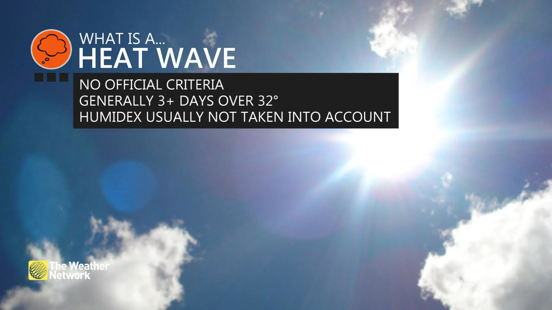
"Next week will bring increasing heat and humidity with high temperatures climbing well into the 30s during the middle of the week with the humidex into the 40s," says Gillham.