B.C. power outages mount as high winds, heavy rain hit province

Strong winds knocked out power to thousands across B.C. as the first of two atmospheric rivers washed over the province on Thursday.
Thousands of homes and businesses across British Columbia are without power on Thursday as high winds knocked down trees and power lines across the region. This round of strong winds is associated with the first of two atmospheric rivers that will bring heavy rain to the province through early next week.
Wind isn’t the only concern with the ongoing unsettled weather. This flip-flop from persistently dry to positively drenched will bring more precipitation than we saw with last week’s systems and some areas may need to watch out for localized flooding.
MUST SEE: B.C.'s 'stormy' pattern won't flip the switch on the current drought
Widespread wind warnings and special weather statements are in effect through much of the day Thursday to advise residents of the potential for wind gusts as high as 80 km/h.
BC Hydro’s list of power outages revealed that more than 35,000 customers were without power by early afternoon on Thursday. Many of the outages were centred around the Lower Mainland and the Sunshine Coast, but thousands of wind-related outages are ongoing across the province.
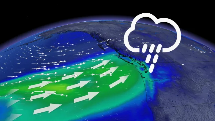
These atmospheric rivers won’t last long, but their high moisture content will produce a decent thump of rain as they move through the region.

The first wave of moisture arrived for the North Coast on Wednesday night and slides south through the day on Thursday. We’ll see the second wave arrive across the Central Coast by late weekend, sliding south into the South Coast by Sunday.
Based on the University of San Diego's Atmospheric River scale, each of these events targeting B.C. in the coming days look to be either a high-end AR1 or low-end AR2 event.

Precipitation totals will vary based on terrain. Northern parts of Metro Vancouver can expect 50-75 mm of rainfall from this late-week storm, with 30-50 mm expected for southern sections. Reduced totals of 10-20 mm are likely for Victoria, thanks to the rain shadow effect. Favoured high elevation areas on the other hand, will see over 100 mm just from this round alone, with more to come this weekend as well.
Widespread rainfall warnings are in effect for this "vigorous frontal system."
While these waves of moisture look to bring beneficial rains to the drought-stricken regions, too much moisture in a short period of time could bring the threat for localized flooding. Dry soils struggle to absorb moisture. Ongoing drought conditions combined with heavy rainfall could lead to more water running off than absorbing into the ground.
Droughts don’t clear up immediately either, and it often takes several systems to tip the balance towards a more traditionally wet pattern.

Windy conditions will also accompany the unsettled weather as these systems track onshore, with gusts up to 80 km/h expected through the day on Thursday. High winds may result in power outages and fallen tree branches and wind warnings have been issued across parts of the interior.
Be sure to check back for the latest on conditions across B.C.