Will Canada's strong start to spring persist? Exclusive April outlook revealed

April looks to offer more changeable weather across the country, including the risk for quick shots of late winter-like weather.
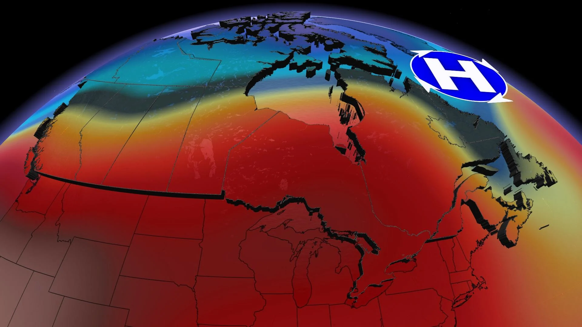
Spring is off to a very strong start across most of Canada. After a frigid February, March featured a dramatic pattern reversal across central Canada with well above seasonal temperatures. While March did live up to its reputation of being a changeable month, the periods of exceptionally warm weather outdueled the parting shots of wintry weather.
The map below shows the temperature anomalies for March, with the various shades of orange and red highlighting the widespread warmer than normal temperatures.
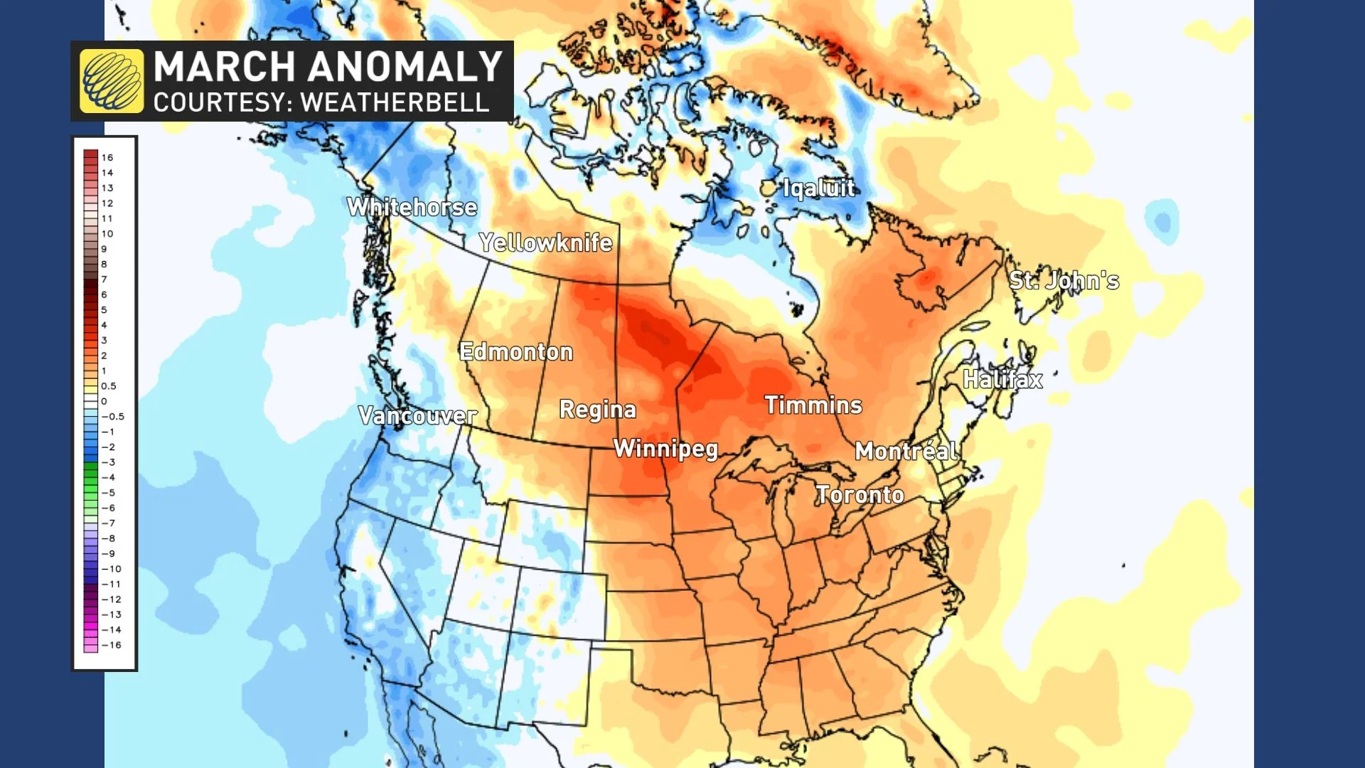
Parts of northern Canada and British Columbia were cooler than normal during March and we expect a similar pattern will continue during April. Here is a look at our forecast for the month of April.
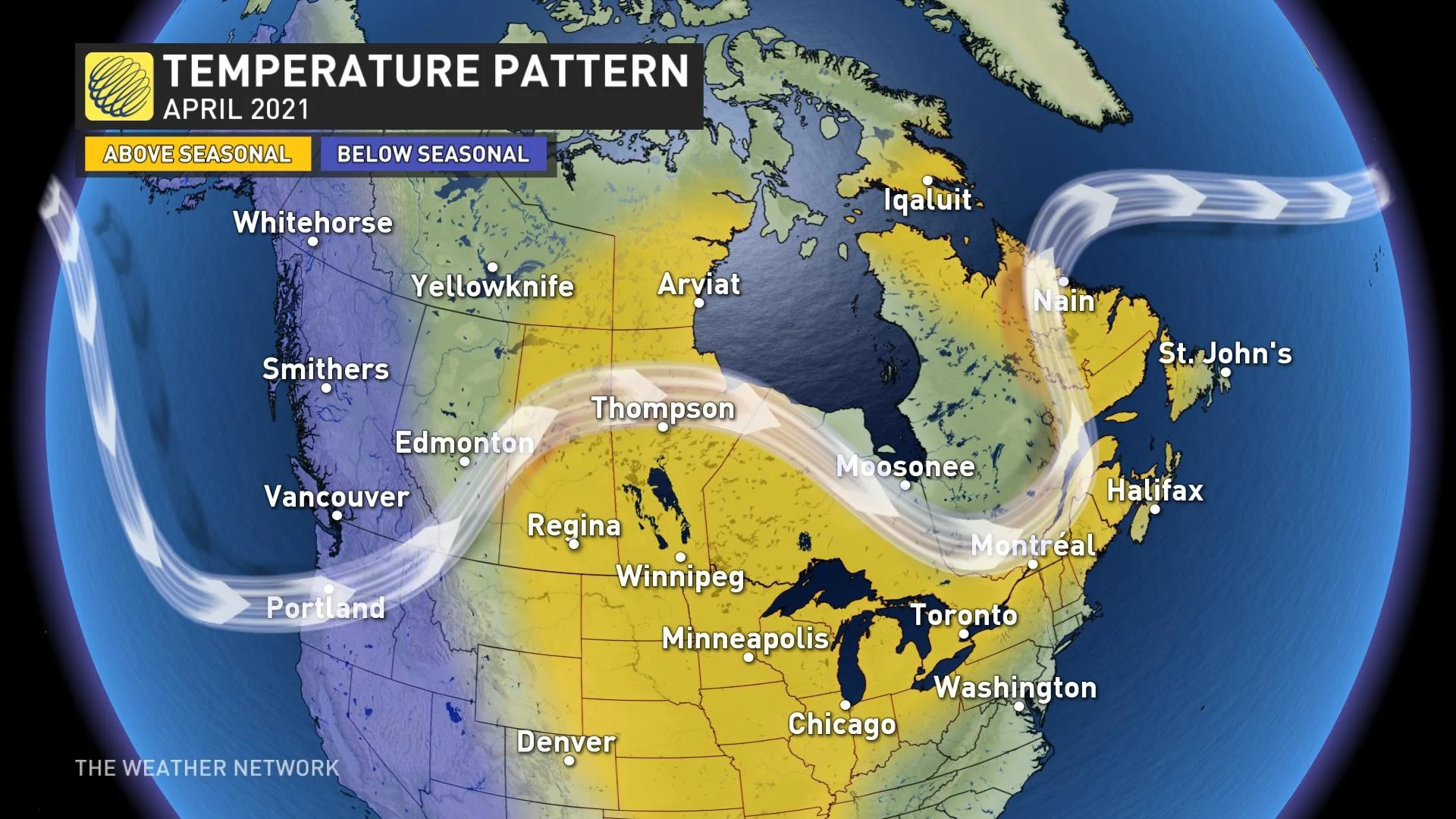
Much like March, we expect above normal and near normal temperatures for areas east of the Rockies. However, we will continue to see changeable weather, including the risk for quick shots of late winter-like weather.
In fact, we are kicking off the month of April with temperatures more typical of late February across much of Ontario and Quebec. However, warmer weather will quickly return to this region as we progress through the Easter long weekend.
In addition, parts of the Maritimes (especially New Brunswick) will have a white Easter, including places that had a green Christmas. More seasonal temperatures will return for the rest of the first week of April.
Visit our Complete Guide to Spring 2021 for an in-depth look at the Spring Forecast, tips to plan for it and much more!
For April as a whole, the warmest weather relative to normal should be found across the eastern Prairies and northwestern Ontario.
For southern Ontario and southern Quebec, we do not expect extended periods of exceptionally warm weather or record-breaking warmth like we saw during March and we even have the risk of seeing periods of cooler than normal weather at times. However, even slightly above seasonal temperatures for the month will still be significantly warmer than what we have seen from April during recent years.
Here are a few more details on what we expect for each region of Canada during April.
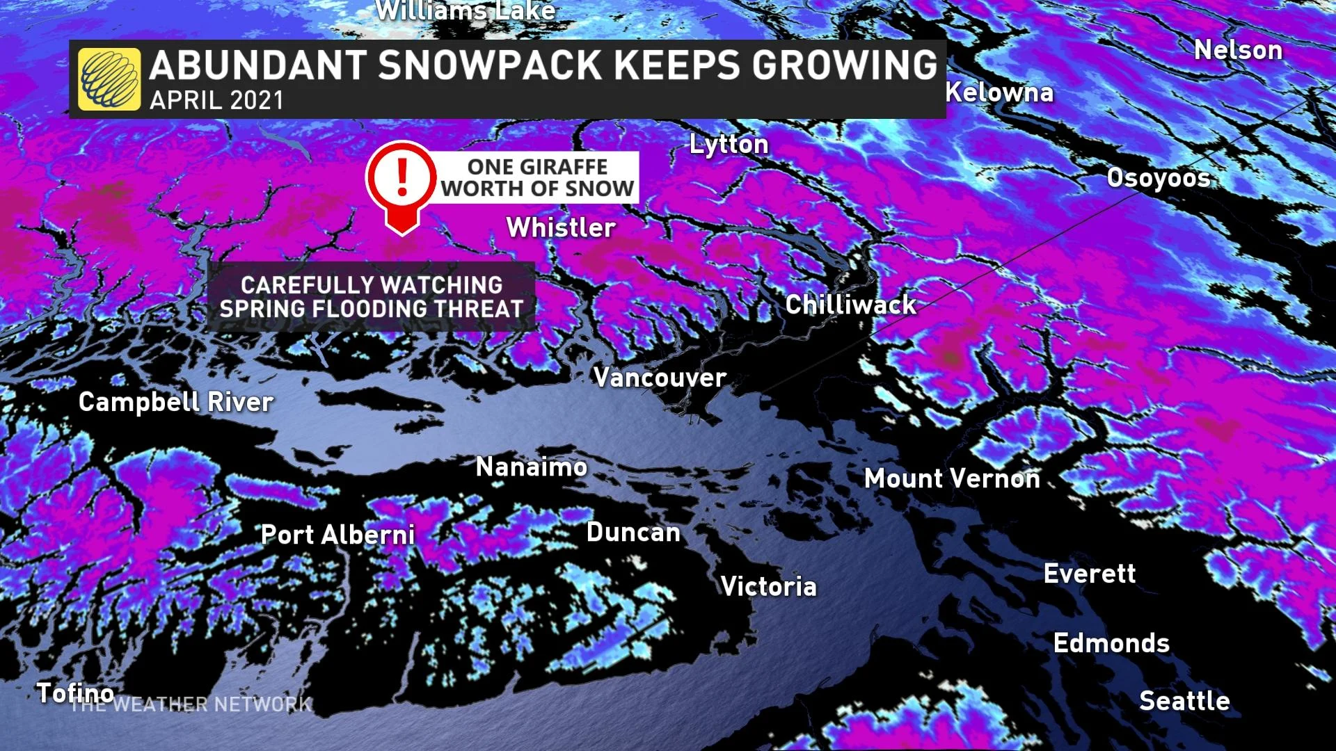
BRITISH COLUMBIA
Temperatures on the cool side of seasonal during April will allow the abundant snowpack to continue to grow in the alpine regions well into April. While the risk for flooding appears to be low during the upcoming month, we will have a heightened risk for flooding when very warm does arrive later in the season.
THE PRAIRIES
Changeable temperatures should come close to offsetting each other across Alberta, but above normal temperatures will be more dominant across central and eastern parts of the region.
Our biggest question and concern regarding April (and May) is whether the much needed precipitation will finally bring some relief from the very dry conditions that continue to worsen, especially across southern parts of the region. Winter was very dry and parts of the region saw less than 10 percent of their normal precipitation during March.
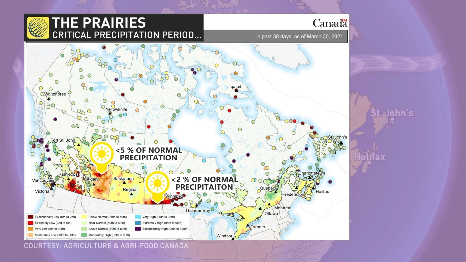
There are indications that April will bring much needed rain to parts of the region. Given the prospects of a dry summer across the southern Prairies, the next two months are a very critical period for this region.
ONTARIO AND QUEBEC
Many April's in recent memory have been rather chilly -- and even wintry at times -- and of course April is famous for its showers.
Will this year reinforce that reputation?
April will test our patience at times, (especially April 1st!) but we do expect that the month as a whole will be slightly warmer than normal, and warmer than many of the April's in our recent memory.
However, after being spoiled by record warmth during March, we do not expect extended periods of record warmth during April. Instead, we should see extended periods of pleasant spring weather. Also, we expect fewer rainy days than normal and above normal amounts of sunshine. However, like March we could still end up with near normal rainfall due to a couple of soggy systems.
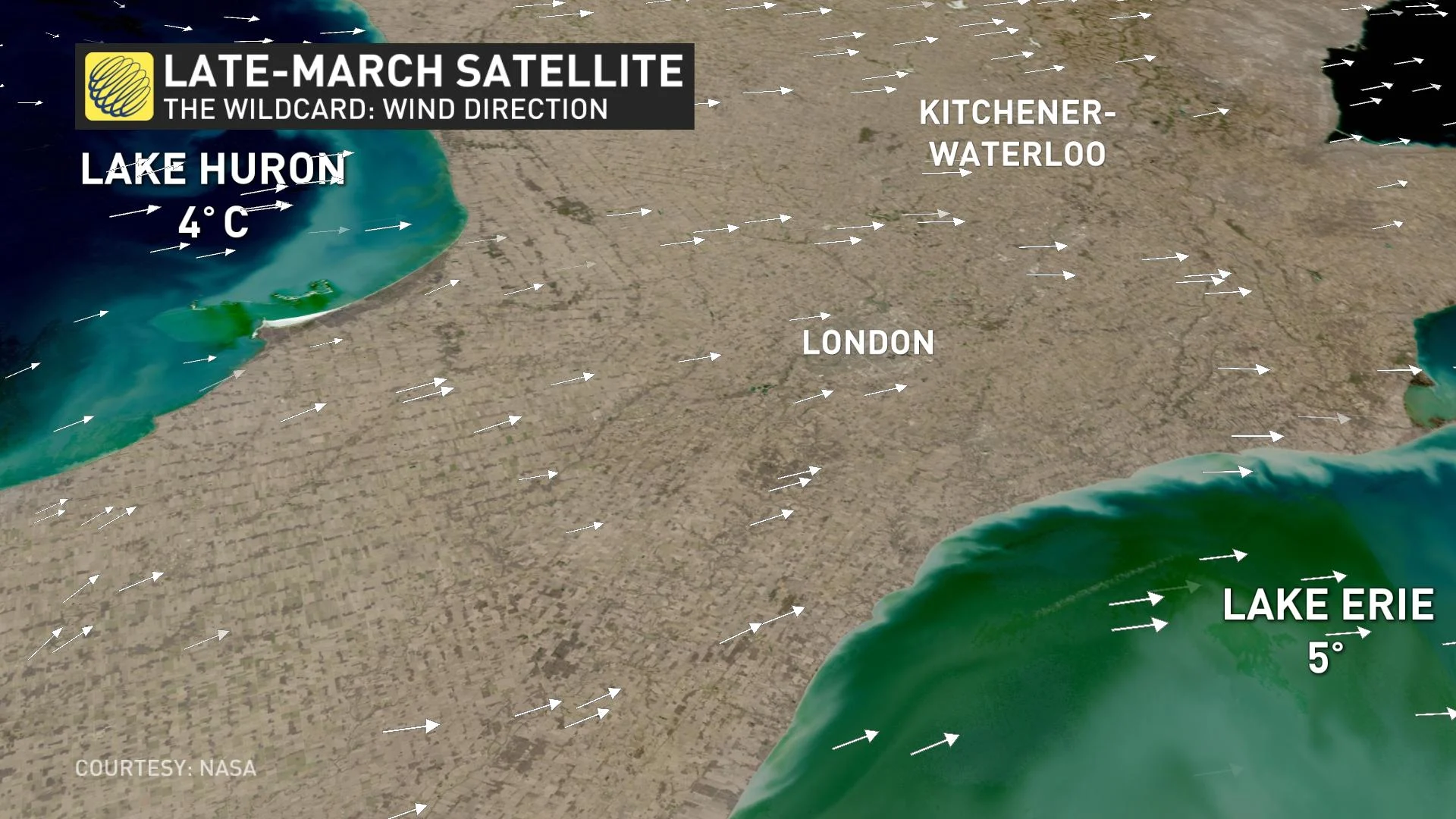
A critical but unknown variable for April every year is the dominant wind direction during our periods of sunny weather, which will have a tremendous impact on the temperatures that we see near the shorelines of the Great Lakes. Residents of the Great Lakes region know that temperatures can suddenly jump or plummet by 10-20 degrees based on whether the wind is blowing off of the land or off the chilly waters of one of the Great Lakes.
ATLANTIC CANADA
The first week of April will bring an abundance of showers across the region, with localized flooding and even some snow for Easter for parts of the region (especially New Brunswick and Labrador). However, periods of warmer and drier weather are expected to outduel the periods of cooler weather for the month as a whole.

NORTHERN CANADA
Much like March, we expect that most of the Yukon territory, including Whitehorse, will be cooler than normal during March. Otherwise, most of the Northwest Territories and Nunavut should be near normal or warmer than normal.
WHAT COULD POSSIBLY GO WRONG? PLEASE READ THE FINE PRINT
When issuing a monthly or seasonal forecast, it is important to evaluate the things that could wrong. Is there anything about the global pattern that could cause the upcoming month or season to end up looking very different from the forecast?
While there is an unusual amount of support for our forecast from the computer models and most of the global pattern drivers, I am most concerned about the risk for a busted forecast across southern Ontario and southern Quebec.
We currently have a blocking pattern over the North Atlantic, and this pattern is notorious for delivering extended periods of chilly weather during spring from the Great Lakes to southern Quebec - similar to what we have seen numerous times over the past five springs.
So, why do we expect a different outcome this year? It is a risk, but we think that the numerous other variables that will be fighting against the cold pattern will win out often enough to tip this region to the warm side of normal. However, this blocking pattern is why we expect the warm pattern will have some significant interruptions at times.