
Most of Canada falls into THIS pattern for May long weekend

Some of the best weather to be found in Canada this May long weekend will be across the Yukon and Northwest Territories!
As we officially pass the mid-May mark and enter into the Victoria Day long weekend, it's only natural to start feeling excited for the nearby summer season now within our reach. Many Canadians will actually coin this weekend as the "unofficial kickoff to summer."
MUST READ: Opening-weekend checklist for your cottage
But for those parts of the country that have been struggling to even see any prolonged pleasant spring conditions, this first weekend of "summer" may be yet another weather disappointment.
"Most of southern Canada will be colder than normal through the May long weekend," says Weather Network meteorologist Dr. Doug Gillham. "In fact, some of the best weather to be found across Canada this weekend will be across the Yukon and Northwest Territories."
Bonus: Early summer-like weather will make a brief appearance in southern Ontario on Sunday.
Here's a closer look at the weather expected in your area this May long weekend:
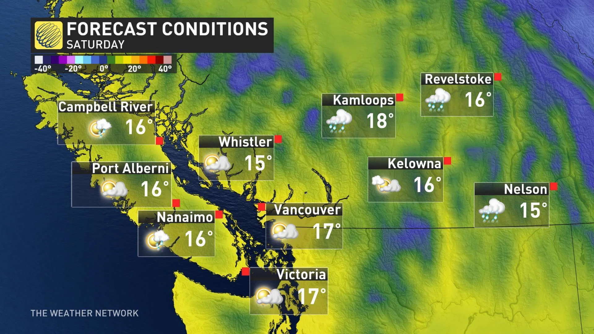
B.C.: A passing shower is possible on Saturday and Sunday but most of the weekend will be rain-free with some sunshine. Monday will bring a higher threat for showers to the south coast, but the day will not be a total washout. Temperatures will be near seasonal (mid teens) across southern B.C. for the weekend with above seasonal conditions expected to the north. Still, it's a far cry from the mid-summer like warmth that recently smashed numerous temperature records across the province.
Alberta: Rain is expected for southern Alberta Friday and Friday night, but snow will fly for the southern and central Rockies and into the foothills. We're also watching the potential for the rain to change to wet snow in the Calgary area during Friday night, but any accumulation in the city should be minor compared to what we saw just a couple weeks ago. The threat for rain showers continues through Saturday across southern Alberta (especially to the west), but it's not expected to be a washout. Temperatures will be well below seasonal across the south, with above seasonal conditions likely in the north. Expect dry weather for Victoria Day with a slight reprieve in temperatures, but will still below the seasonal values which are in the mid to upper teens across the south.
Saskatchewan and Manitoba: It's a rainy outlook for southwestern Saskatchewan, mixed with some wet snow in the Cypress Hills on Friday and lingering into Saturday morning as well. Otherwise, a dry weekend with a mixture of sun and clouds with colder than seasonal temperatures expected across the south. Meanwhile, northern areas will be above seasonal.
WATCH BELOW: LONG WEEKEND FORECAST OUTLOOK
Northern Ontario: Colder than seasonal conditions will last through the long weekend, although staying dry for much of Saturday and Sunday morning. Rain spreads back into the southern regions during Sunday afternoon and Sunday night as a system tracks into the Great Lakes. The rain will mix with wet snow Sunday night north and east of Lake Superior. The mixed precipitation will linger into Monday east of Lake Superior.
MUST READ: Sun worshipers will hate these southern Ontario sky stats
Southern Ontario and southern Quebec: Sunny conditions start off the long on Friday across southern Ontario although rain howers will linger into Friday afternoon across southern Quebec.
There is still some uncertainty in the details of the weekend forecast across southern Ontario, depending on the exact position of the warm front, which will be the dividing line between summer-like warmth to the south and rather cool weather to the north. This front will bring widespread clouds and the threat for a passing shower on Saturday, but most of the region will be cool and dry throughout the day and some peeks of sun are possible for parts of the region.
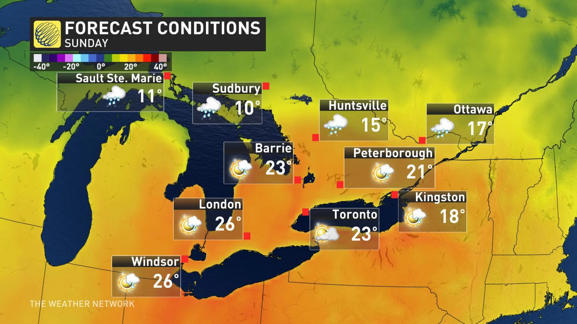
Confidence is increasing that the warm front will lift north into the region for Sunday. This will allow summer-like weather to make a brief appearance across southern Ontario. A large range in temperatures is expected with highs reaching the mid to upper 20s south of the front. A period of showers and thunderstorms and cooler temperatures are expected along and north of the warm front, including cottage country and into southern Quebec. Widespread showers and thunderstorms are likely across the region Sunday night. Monday will be the warmest day of the long weekend across eastern Ontario and southern Quebec with temperatures reaching into the lower 20s, but we will see cooler weather across southern Ontario with a gusty west wind.
Atlantic Canada: Cooler than seasonal temperatures will dominate through the long weekend. Brace for a brisk wind and rain showers as a system tracks across the region on Saturday. We're watching the potential for some flakes to mix in across parts of Newfoundland before the rain ends from west to east during Saturday night and into Sunday.
Another system will bring periods of rain to the Maritimes starting late Sunday and continuing through Monday.

AND THE BEST WEEKEND WEATHER GOES TO...
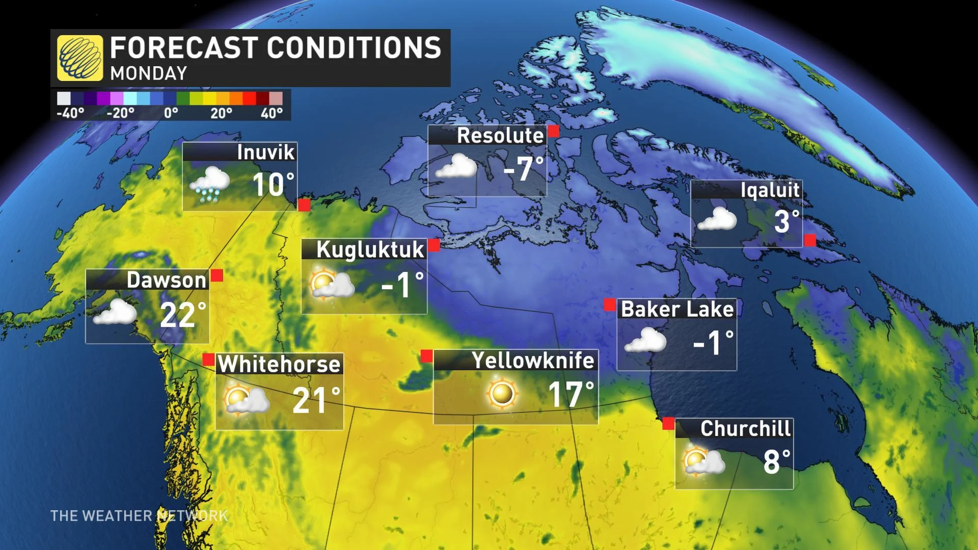
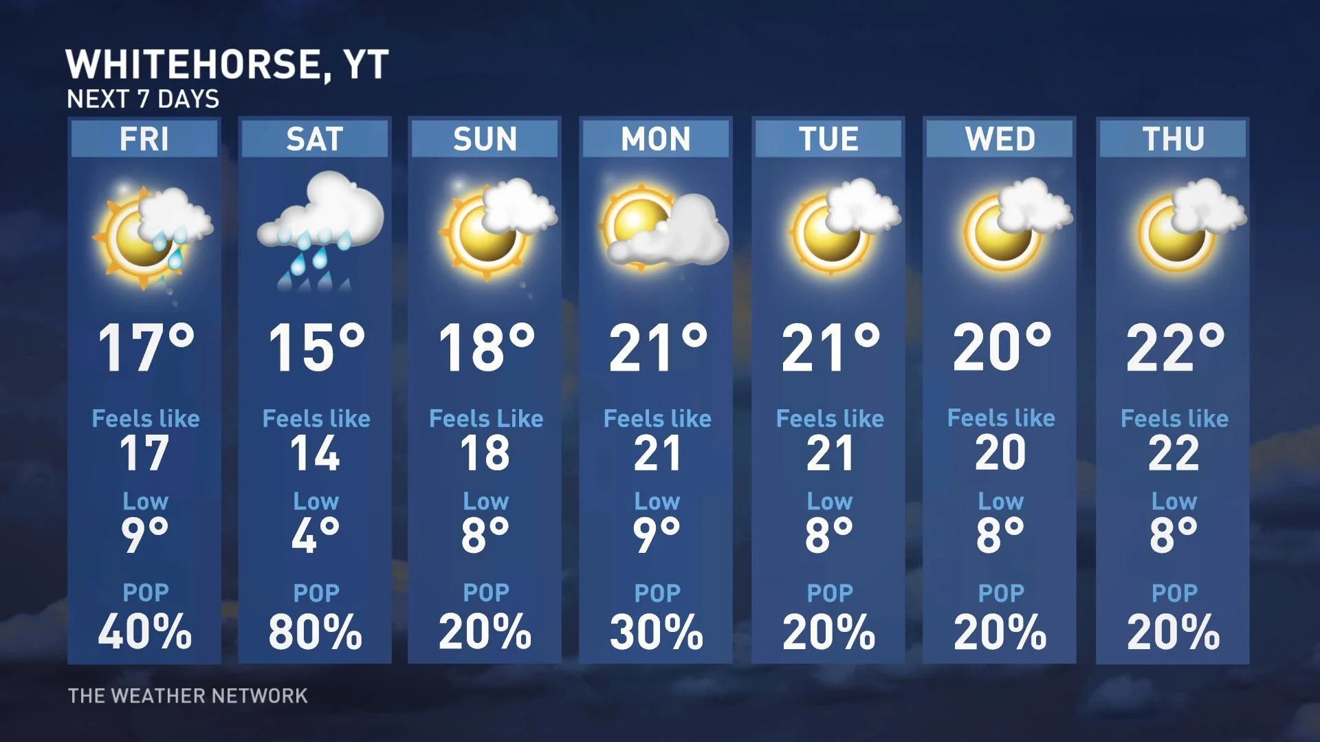
Northern Canada: Now here is some of the best weather in the country! Temperatures will climb into the upper teens and lower 20s by the end of the weekend for Whitehorse. There's a threat for rain showers during the weekend, but mostly rain-free with lots of sunshine. Abundant sunshine will spread across Yellowknife with temperatures in the mid to upper teens, and possibly reaching 20°C on Monday. Near or slightly above seasonal temperatures are forecast for Iqaluit with a mix of sun and clouds on tap.
With files from Weather Network meteorologist Dr. Doug Gillham.