
Ontario: Heavy weekend rain threat, looming Halloween storm

The workweek will end on a calmer, drier note across southern Ontario, but it will be a brief break. The last weekend of the month will bring a tropical infusion to the province in the form of soaking rains and gusty winds. We take a look at what this potential tropical cyclone in the Gulf of Mexico means for our forecast here at home, as well as a look at the tricky Halloween forecast that threatens a significant storm and potential snow, below.
Visit our Complete Guide to Fall 2019 for an in-depth look at the Fall Forecast, tips to plan for it and a sneak peek at the winter ahead
WEATHER HIGHLIGHTS:
Saturday brings another opportunity to get out and enjoy the fall colours
Potential tropical cyclone will feed moisture into Great Lakes region for Sunday
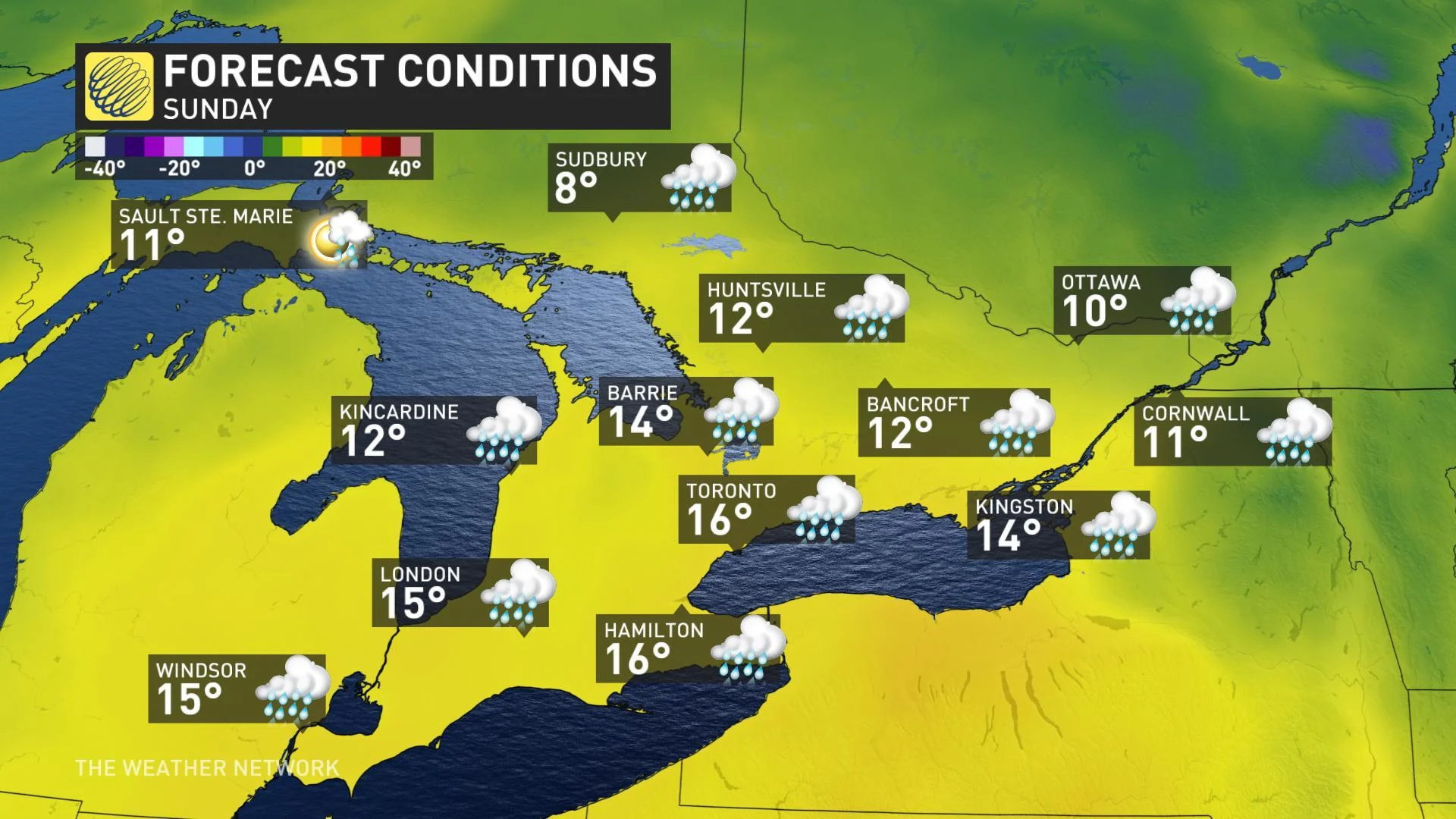
Widespread soaking rain Saturday night, Sunday morning
Potential for late month snow as a colder pattern locks in over the Great Lakes
Stay on top of the ALERTS in your area
WATCH BELOW: TRACKING TROPICAL MOISTURE INTO ONTARIO
While the southern Gulf of Mexico is a long way from southern Ontario, it features prominently in the weekend outlook. Forecasters at the U.S. National Hurricane Center have given a disturbance in the Bay of Campeche a 70 per cent chance of developing into a tropical cyclone over the next 48 hours, and the track of that system -- whether it becomes a cyclone or not -- stands to have an impact on weather in the Great Lakes region this weekend.
Moisture from this system is expected to make its way up the Mississippi Valley through Saturday before bringing a hefty helping of rain to Ontario for Sunday.
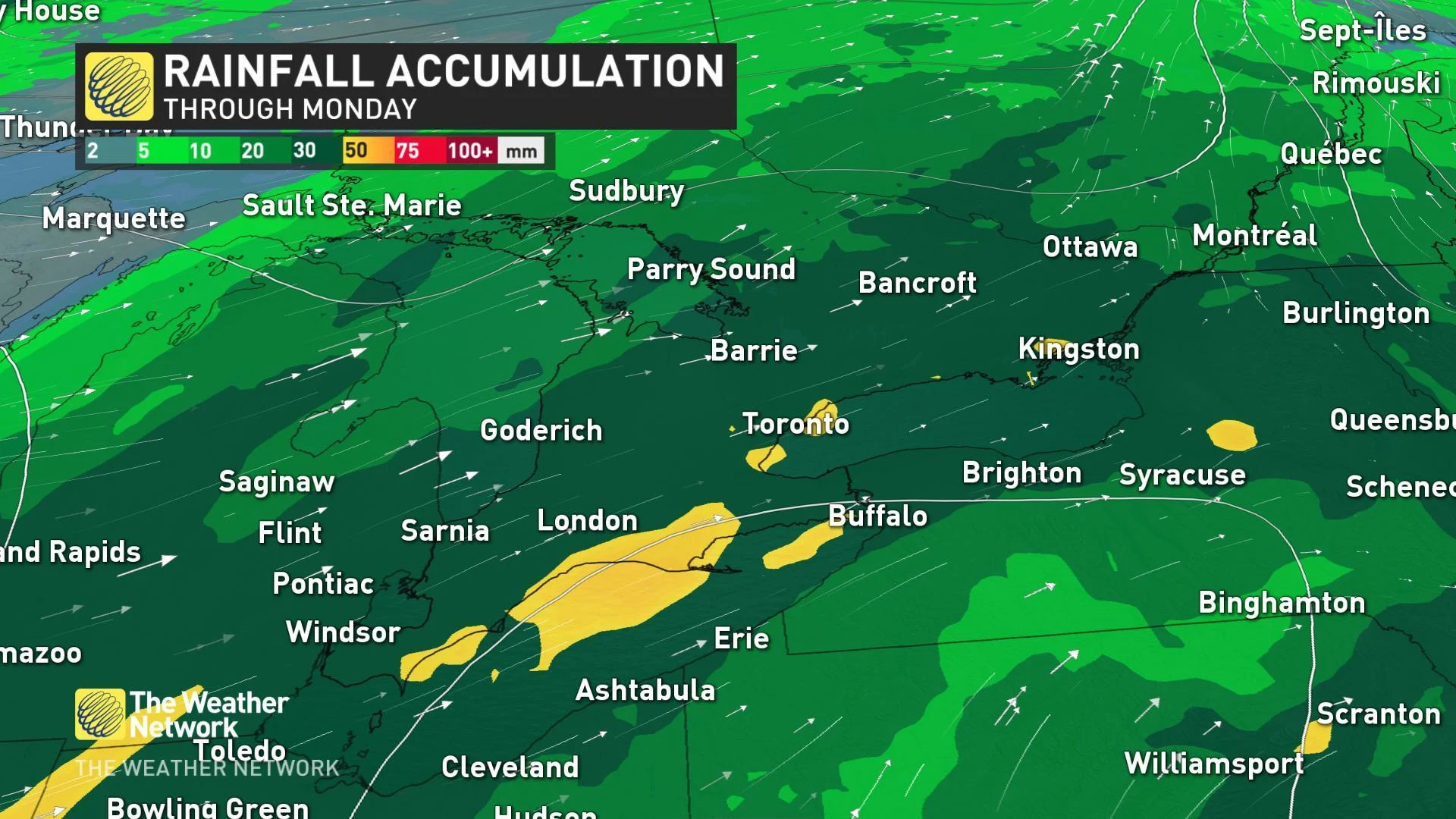
Initial indications show a wide swath of 25+ mm of rain across parts of southern Ontario and into southern Quebec, with pockets of 50 mm or more expected along the Lower Great Lakes. With much of that expected to fall between Saturday night and early Sunday, that could lead to some localized flooding, particularly in spots where sewers are blocked by fallen leaves.
It's not all gloomy for the weekend, however. A burst of southerly air ahead of this system will see seasonal temperatures across the board on Saturday, and a milder -- if rainy -- Sunday.
TRICKY SYSTEM LOOMS FOR HALLOWEEN
After Sunday's system sweeps through, fair and mild conditions return for the start of next week. October's temperamental weather isn't quite finished with Ontario, however, and the stage is set for a potentially potent system as Arctic air attempts to charge in for Halloween.
"A classic fall storm will track along the boundary between the warm and cold air. However, there is still a lot of uncertainty as to where that boundary will be," says The Weather Network's Dr. Doug Gillham. "There are some computer models that keep the boundary to our north and west, which would allow temperatures to climb into the upper teens and lower 20s across the Golden Horseshoe for Wednesday and Halloween."
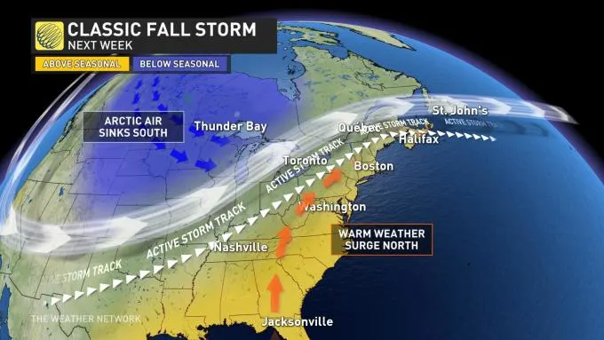
For the other computer models that put the region on the cold side of the boundary, much colder temperatures and lake-effect snow could leave you reaching for extra layers to add to your Halloween costumes for warmth.
Regardless of how Halloween ends up playing out, the cold air will inevitably win out as we head into November.
Be sure to check back as we continue to track these fall storms and potential snow.


