Atlantic: Heavy rain, damaging winds for weekend storm

All eyes are on the next significant system pushing into Atlantic Canada for the weekend, one that will rapidly intensify as it moves over New England and Quebec. While winds won't be as significant as the mid-week storm that knocked out power to thousands across the Maritimes, it will still be a "long duration wind event" with potent gusts expected through Sunday. More on the risk for additional weekend outages across the region, plus a look at the heavy rain and local flood threat that also accompanies this system, below.
WEATHER HIGHLIGHTS:
Potentially damaging winds through the Maritimes this weekend, gusts over 100 km/h possible
Temperatures recover into the weekend with very mild daytime highs
Rain will be the primary precipitation type, though starting as a period of snow in northern New Brunswick and Newfoundland
Stay up-to-date on the ALERTS in your area
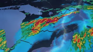
SATURDAY THROUGH SUNDAY-- DAMAGING WINDS, HEAVY RAIN SPREAD INTO THE REGION
With the low tracking well to the west of the Maritimes, this will be a rainy, mild and windy system, with the rain arriving by Saturday morning and continuing right into Sunday afternoon.
As much as 50-75 mm is possible for parts of Nova Scotia's Atlantic coast and the Fundy Coast of New Brunswick, rising to as much as 100 mm for southwestern Newfoundland, and the region as a whole will see substantial downpours.

Any substantial snow with this system will be confined to inland areas of northern New Brunswick, before transitioning through freezing precipitation and changing to straight rain by Saturday night.
Across the gulf, however, Newfoundland will be in for more significant amounts, with the heaviest falling in western parts of the island and across Labrador.
SIGNIFICANT WIND EVENT
The most significant risk with this system will likely be the potentially damaging winds with gusts between 70-100+ km/h expected.
"This will be a long duration strong wind event for Atlantic Canada, starting Saturday afternoon and continuing through Monday," says Weather Network meteorologist Dr. Doug Gillham.
The strongest winds will be across Nova Scotia, PEI, southern New Brunswick and coastal Newfoundland, with the risk for localized power outages and some downed trees.
HUGE TEMPERATURE BOOST
One saving grace perhaps with this system will be the spring-like daytime highs. A substantial boost to above seasonal temperatures is expected for most of the weekend, as some areas across the south see daytime highs soar into double-digit territory.

By late Sunday and into Monday, temperatures take another tumble towards freezing, with forecasters closely watching a Colorado Low tracking south of the region by Tuesday.
"There is the potential for some significant snow with this, but at this point, it does not look like a major storm for the region," Gillham adds.