Watch? Warning? How we communicate severe weather in Canada

Tornado season has arrived for parts of Canada. Here's a guide to how severe weather is communicated to the public.
With the approach of summer, forecasters will be on the lookout for more outbreaks of severe weather, and when extreme weather looms in Canada, there is a progression of statements, watches and warnings issued to inform and protect the public.
Here is a guide to those alerts.
Weather of concern
When active weather is expected or occurring, but there's no current indication that conditions will be severe or extreme, Environment Canada issues a Special Weather Statement.
This is a text statement, giving forecasters a chance to explain unusual conditions or weather of concern that a region may soon experience - heavy rainfall, thunderstorms, strong winds, and/or high humidex values.
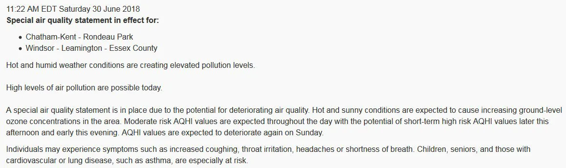
This special weather statement was issued in southwestern Ontario, on June 20, 2018, due to the potential for hot and humid weather that was expected to give rise to conditions of poor air quality. Credit: ECCC
Essentially, any conditions that would certainly affect someone's day, but are not expected to develop to the point where they would qualify as severe weather.
Special weather statements are indicated on Environment and Climate Change Canada's Public Weather Alerts map by regions highlighted in grey.
Watching for danger
Beyond weather of concern, there are times when the forecast indicates that conditions are favourable for severe weather, but it has not yet developed.
In order to alert the public of this potential, while at the same time ensuring that they do not cause unwarranted alarm, a Watch is issued.
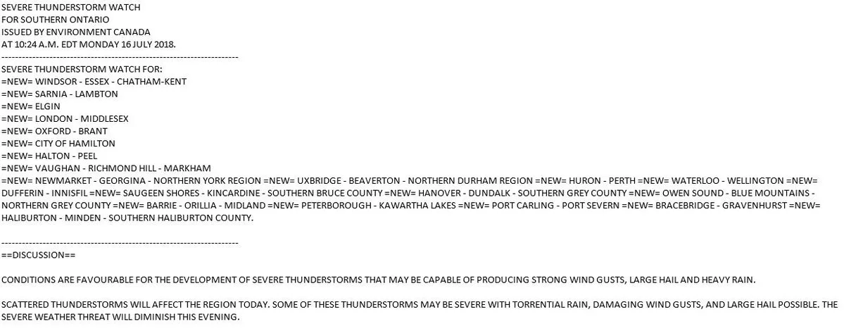
On Monday, July 16, 2018, forecasters issued severe thunderstorm watches across several regions of southern Ontario. Credit: ECCC
As the name implies, a watch means that forecasters are watching for severe weather conditions to develop.
When a watch is active, the public need not take any specific actions in response, but they should at least stay aware of the situation, and they should be prepared to take action if severe weather conditions develop.
Watches are indicated on Environment and Climate Change Canada's Public Weather Alerts map by regions highlighted in yellow.
Imminent or occurring
When conditions advance past simply having the potential for severe weather, and severe weather is actually developing or occurring, forecasters issue a Warning.
Exactly when a warning is issued usually depends on what kind of weather is expected.
For severe thunderstorms and tornadoes, the ideal goal is to follow a specific progression, of course. First a watch is issued, and this is followed by upgrading those watches to warnings as the storms or tornadoes develop. Thus, a severe thunderstorm watch could be in effect for much of the day, and then it is replaced by a severe thunderstorm warning as the storms pop up on radar.
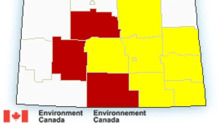
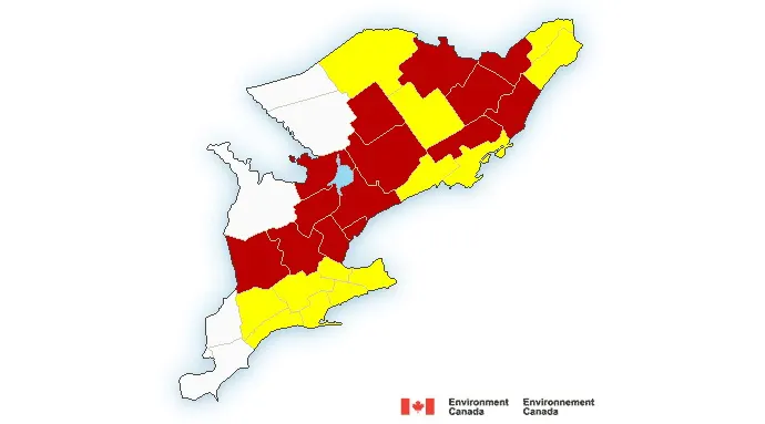
Watches (yellow) and warnings (red) are indicated across southern Saskatchewan on this sample Public Weather Alerts Map from Environment and Climate Change Canada. At this time, severe thunderstorms would have been tracking across those regions in red. Regions under the watches, to the east, could have had potentially severe storms at that time, or they may have been under watch due to the potential for the severe storms to persist into those regions. Credit: ECCC
Tornado watches and warnings are a somewhat special case. Tornado watches can be issued, instead of severe thunderstorm watches, in the case where weather conditions specifically indicate the potential for the development of storms capable of producing tornadoes. After that, they would simply be upgraded to warnings if the tornadic storms developed.
It can happen, though, that tornado watches and warnings are issued during a storm event, perhaps as a line of severe thunderstorms is tracking across a region. Specific storms in the line could be identified as potentially tornadic, prompting a watch, or they could suddenly develop rotation, causing forecasters to immediately issue a tornado warning for those in the storm's path.
Watches and warnings issued throughout southern Ontario could include a mix of alerts for severe thunderstorms and tornadoes. Credit: ECCC
Since there are cases when severe conditions can pop up with little notice, however, it is also possible for a warning to be issued spontaneously.
Although it is fairly rare, we can see this when non-severe thunderstorms suddenly encounter conditions, which were not clearly evident beforehand, that cause them to intensify and even develop rotation. In this case, forecasters would immediately issue a severe thunderstorm warning, or possibly even a tornado warning.
Warnings are indicated on Environment and Climate Change Canada's Public Weather Alerts map by regions highlighted in red.
How severe is 'severe'?
What does it take for a watch or warning to be issued for severe weather?
Heavy Rainfall Warning
The forecast indicates the potential for 50 mm of rain, or more, expected to fall within one hour (25 mm for coastal provinces and territories, 15 mm for the dry B.C. interior).
These rainfall amounts are sufficient to cause ponding on roads, overland flooding as rainfall amounts exceed the ground's ability to absorb the water, and even flooding risks along swollen streams and rivers.
Severe Thunderstorm Watch
Conditions are favourable for a thunderstorm to develop, with the potential to produce one or more of the following:
Wind gusts of at least 90 km/h
Hail of at least two centimetres in size
Heavy rainfall, as above
In addition to the ponding and flooding concerns noted above, hail and wind from these storms can cause significant damage to property and pose a potential risk of injury.
Severe Thunderstorm Warning
A storm with one or more of the above Watch criteria is imminent, or has actually been seen on radar and/or satellite imagery, or reported by a reliable weather spotter.
Tornado Watch
Weather conditions - temperature, humidity, atmospheric instability, winds, etc - are favourable for the development of severe thunderstorms that could produce one or more tornadoes. Thunderstorms or severe thunderstorms may or may not be actually occurring for a tornado watch to be issued.
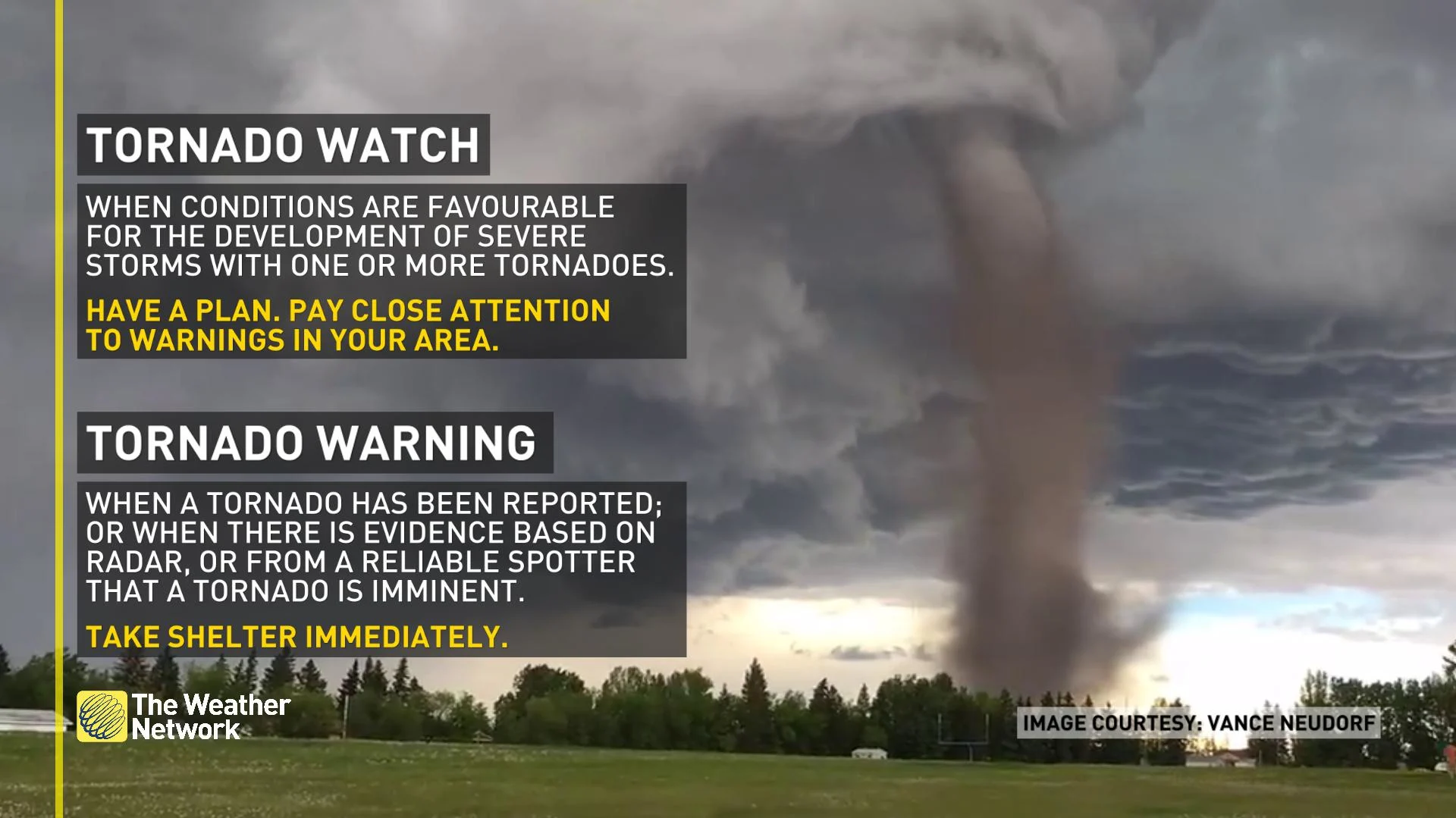
Tornado Warning
A tornado has been reported; or when there is evidence that tornado formation is imminent, based on Doppler radar scans or reports from a reliable spotter.
It is important to note that, since radar does not typically see activity below the base of a storm, it is possible for a storm to show rotation on radar, and yet have no tornado affecting the ground, at that time.
In this case, to protect the public, the imminent threat is enough. Even if a tornado does not actually develop from the storm's rotation, the potential danger to anyone in the storm's path provides ample justification for ECCC forecasters to issue a tornado warning.
Getting the message out
When Environment and Climate Change Canada alerts Canadians to risky conditions, The Weather Network distributes those warnings on this website, on television, on smartphones through our apps, by text messages and to other broadcasters through the Alert Ready public-safety messaging system.
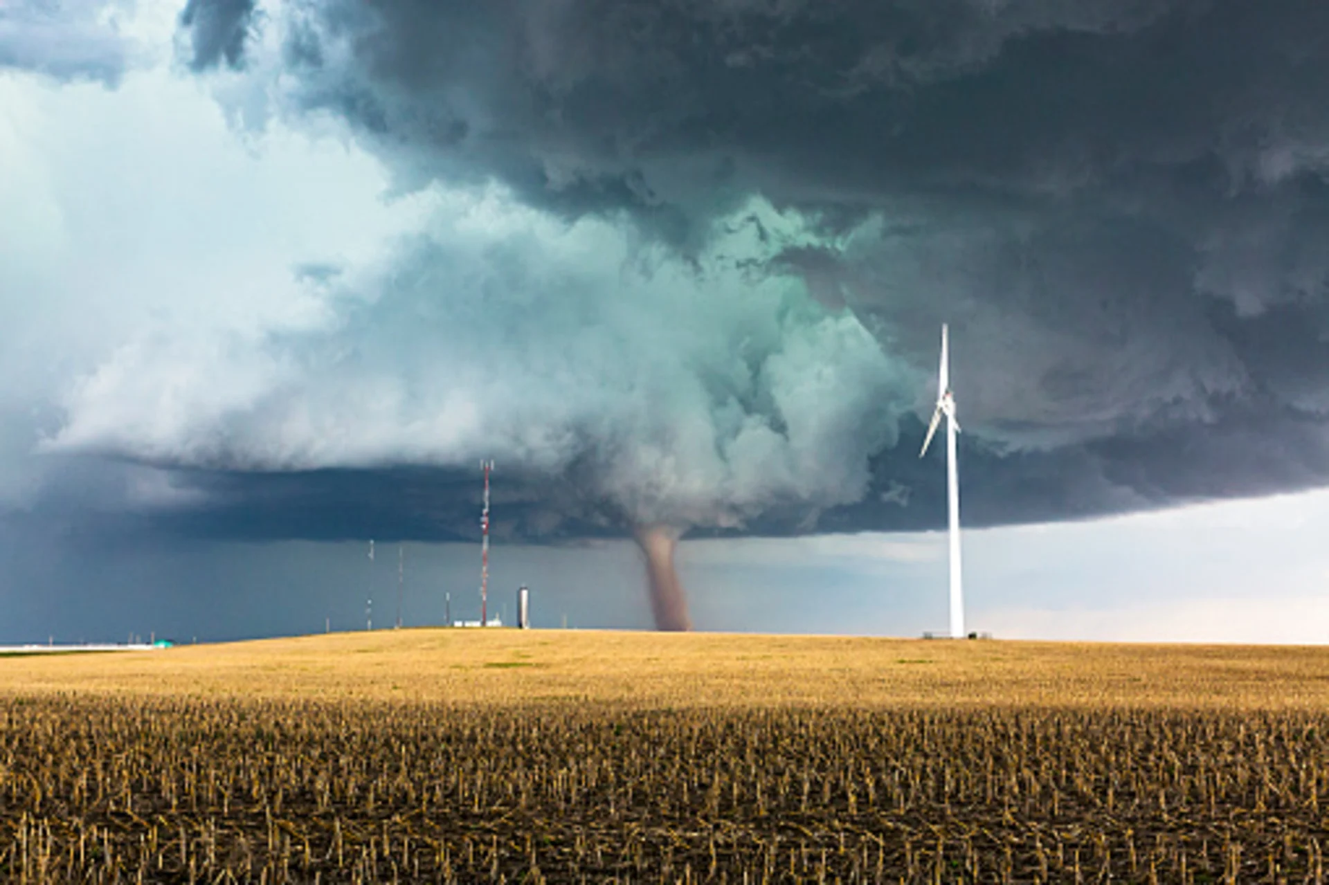
Watch below: Spot a tornado in canada? Report it to the northern tornadoes project!
Thumbnail photo credit: Getty Images/stock