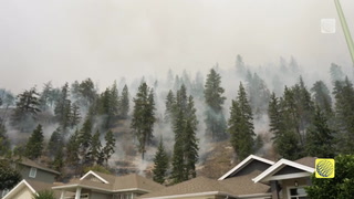
Active AlertsTomball, TX
Turn around, don't drown when encountering flooded roads. Most flooddeaths occur in vehicles.Please report observed flooding to local emergency services or lawenforcement and request they pass this information to the NationalWeather Service when you can do so safely.Motorists should not attempt to drive around barricades or drivecars through flooded areas.Additional information is available at www.weather.gov/hgx.The next statement will be issued by late tonight at 230 AM CDT.
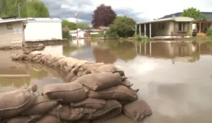
...The Flood Warning is extended for the following rivers in Texas...East Fork San Jacinto near New Caney affecting Montgomery,Liberty and Harris Counties....The Flood Warning continues for the following rivers in Texas...San Jacinto River near Sheldon affecting Harris County.West Fork San Jacinto near Humble affecting Montgomery and HarrisCounties.For the East Fork San Jacinto River...including New Caney...Moderateflooding is forecast.For the West Fork San Jacinto River...including Humble, Sheldon...Major flooding is forecast.* WHAT...Major flooding is occurring and major flooding is forecast.* WHERE...West Fork San Jacinto near Humble.* WHEN...Until Wednesday evening.* IMPACTS...At 54.4 feet, Major lowland flooding continues withhomes along Riverview Drive in River Ridge subdivision upstream ofthe gauge begin to flood.* ADDITIONAL DETAILS...- At 7:45 AM CDT Monday the stage was 54.1 feet.- Bankfull stage is 15.0 feet.- Recent Activity...The maximum river stage in the 24 hoursending at 7:45 AM CDT Monday was 56.2 feet.- Forecast...The river is expected to fall below flood stageWednesday morning and continue falling to 45.7 feet Saturdaymorning.- Flood stage is 49.3 feet.- Flood History...This crest compares to a previous crest of54.2 feet on 10/19/1998.- http://www.weather.gov/safety/flood
Turn around, don't drown when encountering flooded roads. Most flooddeaths occur in vehicles.Please report observed flooding to local emergency services or lawenforcement and request they pass this information to the NationalWeather Service when you can do so safely.Motorists should not attempt to drive around barricades or drivecars through flooded areas.Additional information is available at www.weather.gov/hgx.The next statement will be issued by late tonight at 230 AM CDT.
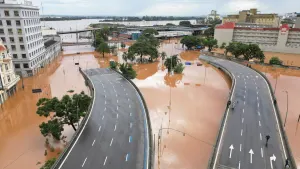
...The Flood Warning is extended for the following rivers in Texas...East Fork San Jacinto near New Caney affecting Montgomery,Liberty and Harris Counties....The Flood Warning continues for the following rivers in Texas...San Jacinto River near Sheldon affecting Harris County.West Fork San Jacinto near Humble affecting Montgomery and HarrisCounties.For the East Fork San Jacinto River...including New Caney...Moderateflooding is forecast.For the West Fork San Jacinto River...including Humble, Sheldon...Major flooding is forecast.* WHAT...Moderate flooding is occurring and moderate flooding isforecast.* WHERE...San Jacinto River near Sheldon.* WHEN...Until Wednesday afternoon.* IMPACTS...At 13.0 feet, Moderate lowland flooding begins withwidespread inundation of the flood plain.* ADDITIONAL DETAILS...- At 7:15 AM CDT Monday the stage was 14.7 feet.- Bankfull stage is 8.0 feet.- Recent Activity...The maximum river stage in the 24 hoursending at 7:15 AM CDT Monday was 17.5 feet.- Forecast...The river is expected to fall below flood stageearly Wednesday morning and continue falling to 3.8 feetSaturday morning.- Flood stage is 10.0 feet.- Flood History...This crest compares to a previous crest of14.7 feet on 06/27/1989.- http://www.weather.gov/safety/flood