Active AlertsShepherd, TX
You should monitor later forecasts and be alert for possible FloodWarnings. Those living in areas prone to flooding should be preparedto take action should flooding develop.
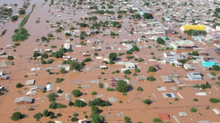
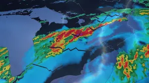
* WHAT...Flooding caused by excessive rainfall continues to bepossible.* WHERE...A portion of southeast Texas, including the followingareas, Brazos, Grimes, Houston, Madison, Montgomery, NorthernLiberty, Polk, San Jacinto, Trinity and Walker.* WHEN...Through Monday morning.* IMPACTS...Excessive runoff may result in flooding of rivers,creeks, streams, and other low-lying and flood-prone locations.Flooding may occur in poor drainage and urban areas. Area creeksand streams are running high and could flood with more heavy rain.* ADDITIONAL DETAILS...- Scattered showers and thunderstorms will continue intotonight. Radar estimated rain totals so far has been 1 to 3"within the watch area with isolated higher amounts innorthern Houston County to 4". An additional 1-3" inches ispossible through tonight as the showers and storms persist.Area soils are already saturated due to previous heavy rainevents with 1 and 3 hour Flash Flood Guidance around 2 to 3inches, so the additional heavy rainfall may result in flashflooding. There will be a lull in the precipitation latetonight into Monday morning, but additional showers andstorms are likely Monday afternoon. The Watch expiration timewill remain the same for now, but it may be extended duringlater updates.- http://www.weather.gov/safety/flood
Turn around, don't drown when encountering flooded roads. Most flooddeaths occur in vehicles.Motorists should not attempt to drive around barricades or drivecars through flooded areas.Please report observed flooding to local emergency services or lawenforcement and request they pass this information to the NationalWeather Service when you can do so safely.Additional information is available at www.weather.gov/hgx.The next statement will be issued byMonday afternoon at 330 PM CDT.
...The Flood Warning continues for the following rivers in Texas...Trinity River near Goodrich affecting Liberty, San Jacinto andPolk Counties.For the Trinity River...including Crockett, Riverside, Goodrich,Liberty, Moss Bluff...Major flooding is forecast.* WHAT...Minor flooding is occurring and minor flooding is forecast.* WHERE...Trinity River near Goodrich.* WHEN...Until further notice.* IMPACTS...At 38.0 feet, Moderate lowland flooding begins.* ADDITIONAL DETAILS...- At 8:45 PM CDT Sunday the stage was 37.3 feet.- Bankfull stage is 36.0 feet.- Recent Activity...The maximum river stage in the 24 hoursending at 8:45 PM CDT Sunday was 37.3 feet.- Forecast...The river is expected to rise to a crest of 37.6feet tomorrow morning.- Flood stage is 36.0 feet.- Flood History...This crest compares to a previous crest of37.2 feet on 03/15/2001.- http://www.weather.gov/safety/flood