Active AlertsOrchard, TX
Please report observed flooding to local emergency services or lawenforcement and request they pass this information to the NationalWeather Service when you can do so safely.Turn around, don't drown when encountering flooded roads. Most flooddeaths occur in vehicles.Motorists should not attempt to drive around barricades or drivecars through flooded areas.Additional information is available at www.weather.gov/hgx.The next statement will be issued by late tonight at 330 AM CDT.
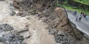
...The Flood Warning is extended for the following rivers in Texas...Long King Creek near Livingston affecting San Jacinto and PolkCounties.Brazos River near West Columbia affecting Brazoria County.Brazos River near Rosharon affecting Brazoria and Fort BendCounties.Brazos River at US 59, Sugar Land, TX affecting Fort Bend County....The Flood Warning continues for the following rivers in Texas...Trinity River near Crockett affecting Walker, Madison, Trinityand Houston Counties.Trinity River at Liberty affecting Liberty County.Trinity River near Moss Bluff affecting Chambers and LibertyCounties.Trinity River at Riverside affecting San Jacinto, Trinity, Walkerand Polk Counties.For the Trinity River...including Crockett, Riverside, Goodrich,Liberty, Moss Bluff...Major flooding is forecast.For the Long King Creek...including Livingston...Minor flooding isforecast.For the Brazos River...including West Columbia, US 59, Sugar Land,TX, Richmond, Rosharon...Moderate flooding is forecast.* WHAT...Minor flooding is occurring and minor flooding is forecast.* WHERE...Brazos River near Rosharon.* WHEN...Until Thursday evening.* IMPACTS...At 46.5 feet, Minor lowland flooding continues.Livestock should be removed from low areas in the flood plain.* ADDITIONAL DETAILS...- At 9:00 AM CDT Monday the stage was 46.9 feet.- Bankfull stage is 40.0 feet.- Recent Activity...The maximum river stage in the 24 hoursending at 9:00 AM CDT Monday was 47.0 feet.- Forecast...The river is expected to fall below flood stageThursday morning and continue falling to 41.3 feet Saturdaymorning.- Flood stage is 43.0 feet.- Flood History...This crest compares to a previous crest of47.1 feet on 07/12/2007.- http://www.weather.gov/safety/flood
Please report observed flooding to local emergency services or lawenforcement and request they pass this information to the NationalWeather Service when you can do so safely.Turn around, don't drown when encountering flooded roads. Most flooddeaths occur in vehicles.Motorists should not attempt to drive around barricades or drivecars through flooded areas.Additional information is available at www.weather.gov/hgx.The next statement will be issued by late tonight at 330 AM CDT.
...The Flood Warning is extended for the following rivers in Texas...Long King Creek near Livingston affecting San Jacinto and PolkCounties.Brazos River near West Columbia affecting Brazoria County.Brazos River near Rosharon affecting Brazoria and Fort BendCounties.Brazos River at US 59, Sugar Land, TX affecting Fort Bend County....The Flood Warning continues for the following rivers in Texas...Trinity River near Crockett affecting Walker, Madison, Trinityand Houston Counties.Trinity River at Liberty affecting Liberty County.Trinity River near Moss Bluff affecting Chambers and LibertyCounties.Trinity River at Riverside affecting San Jacinto, Trinity, Walkerand Polk Counties.For the Trinity River...including Crockett, Riverside, Goodrich,Liberty, Moss Bluff...Major flooding is forecast.For the Long King Creek...including Livingston...Minor flooding isforecast.For the Brazos River...including West Columbia, US 59, Sugar Land,TX, Richmond, Rosharon...Moderate flooding is forecast.* WHAT...Minor flooding is occurring and minor flooding is forecast.* WHERE...Brazos River at US 59, Sugar Land, TX.* WHEN...Until early tomorrow afternoon.* IMPACTS...At 67.5 feet, Minor flooding continues as Baudet Roadhas close to one foot of water over the road.* ADDITIONAL DETAILS...- At 8:00 AM CDT Monday the stage was 67.1 feet.- Bankfull Stage is 40.0 feet.- Recent Activity...The maximum river stage in the 24 hoursending at 8:00 AM CDT Monday was 67.6 feet.- Forecast...The river is expected to fall below flood stagetomorrow morning and continue falling to 61.5 feet Saturdaymorning.- Flood stage is 65.5 feet.- Flood History...This crest compares to a previous crest of65.5 feet on 06/06/2021.- http://www.weather.gov/safety/flood
Turn around, don't drown when encountering flooded roads. Most flooddeaths occur in vehicles.Please report observed flooding to local emergency services or lawenforcement and request they pass this information to the NationalWeather Service when you can do so safely.
* WHAT...Urban and small stream flooding caused by excessiverainfall is expected.* WHERE...A portion of southeast Texas, including the followingcounties, Brazoria, Chambers, Fort Bend, Harris, Liberty andWaller.* WHEN...Until 515 PM CDT.* IMPACTS...Minor flooding in low-lying and poor drainage areas.Ponding of water in urban or other areas is occurring or isimminent.* ADDITIONAL DETAILS...- At 206 PM CDT, Doppler radar indicated heavy rain due tothunderstorms. This will cause urban and small streamflooding. Up to 2 inches of rain have fallen.- Additional rainfall amounts of 1 to 3 inches are expectedover the area. This additional rain will result in minorflooding.- Some locations that will experience flooding include...Pasadena, Pearland, Sugar Land, Baytown, Missouri City, DeerPark, Rosenberg, Stafford, South Houston, Bellaire, Humble,West University Place, Katy, Richmond, Galena Park, JacintoCity, Jersey Village, northwestern Manvel, Hunters CreekVillage and Bunker Hill Village.- http://www.weather.gov/safety/flood