Power outages, damage possible as powerful storm set to slam B.C.

A potent frontal system moving onto the B.C. coast has the potential to bring far-reaching, damaging wind impacts, as well as localized flooding, Tuesday.
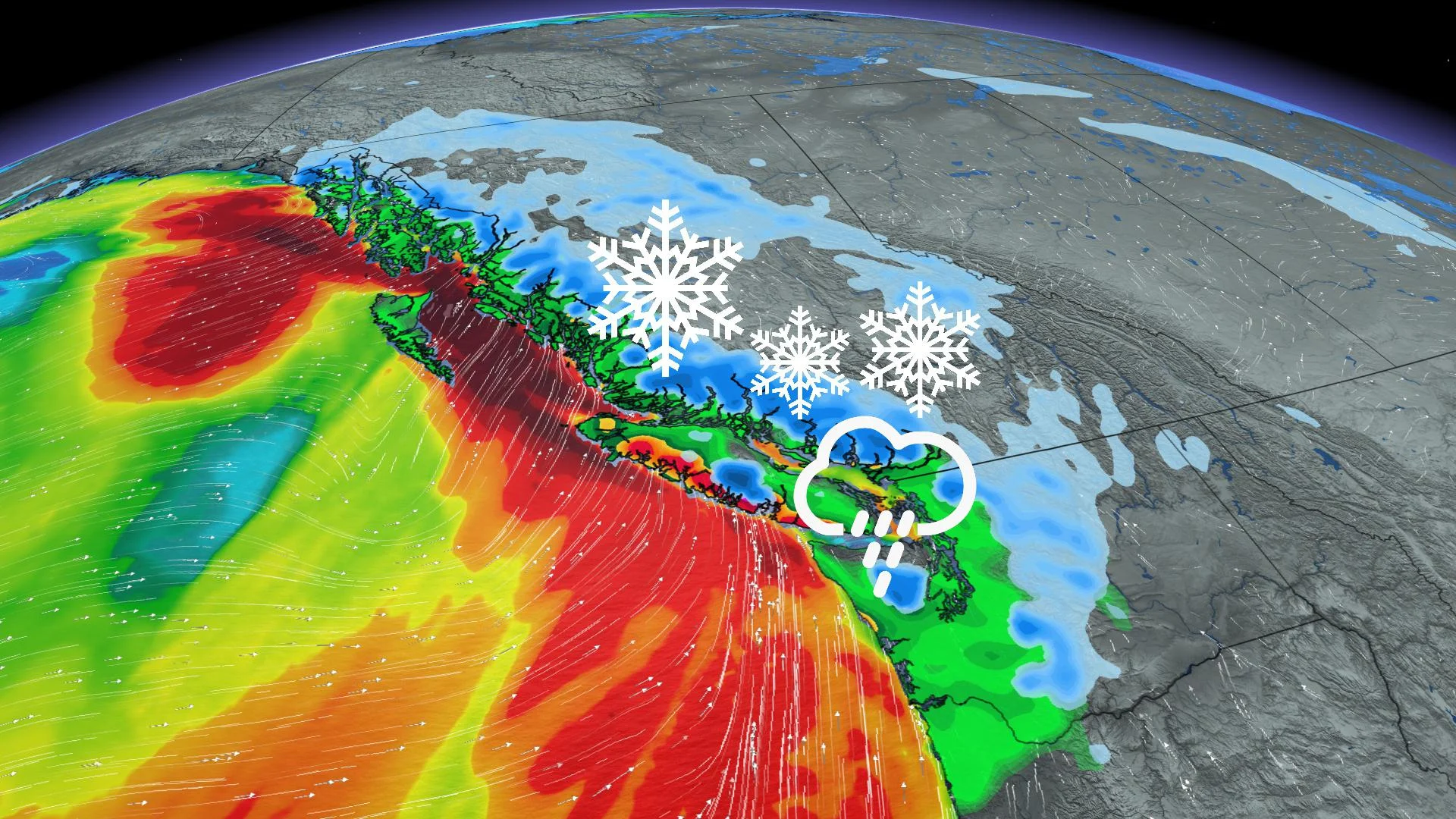
The unyielding parade of powerful Pacific lows in B.C. continues with a front that has the potential to bring far-reaching, damaging impacts Tuesday. The system will bring heavy rain and blustery, potentially damaging winds for the coastal regions, and snow for the alpine regions and the Interior. This could cause localized flooding due to saturated grounds from previous rains, power outages, interruptions to ferry services and possible avalanches, resulting from the fresh snowpack in the mountain passes. More details on the incoming storm, as well as the active pattern continuing beyond, below.
WEATHER HIGHLIGHTS:
Strong low moves onto the coast, will bring heavy rain, strong winds, alpine snow Tuesday
Potential for widespread damaging winds, power outages, localized flooding, ferry interruptions, avalanches Tuesday
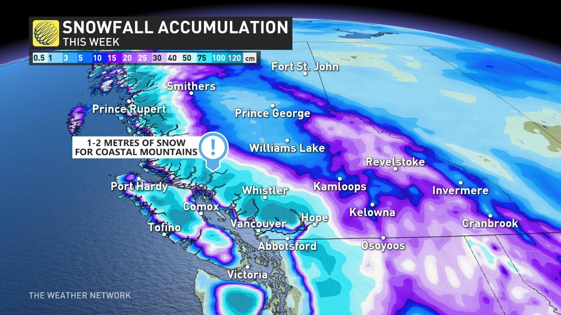
Alpine regions could see up to 2 metres of snow by the end of this week
TUESDAY: STRONG STORM TO BRING POTENTIALLY DAMAGING WINDS, HEAVY RAIN, ALPINE SNOW
A strong frontal system will bring heavy rainfall, alpine snow and strong wind gusts Tuesday, beginning in the morning hours in the north coast and Vancouver Island, and the South Coast through the afternoon. Wind, snowfall and rainfall warnings are in effect.
By early Tuesday afternoon, rainfall picks up across the Vancouver area and continues through the overnight before easing in the early morning hours of Wednesday.
MUST SEE: B.C. stays 'wet and wild' in a country-wide milder start to January
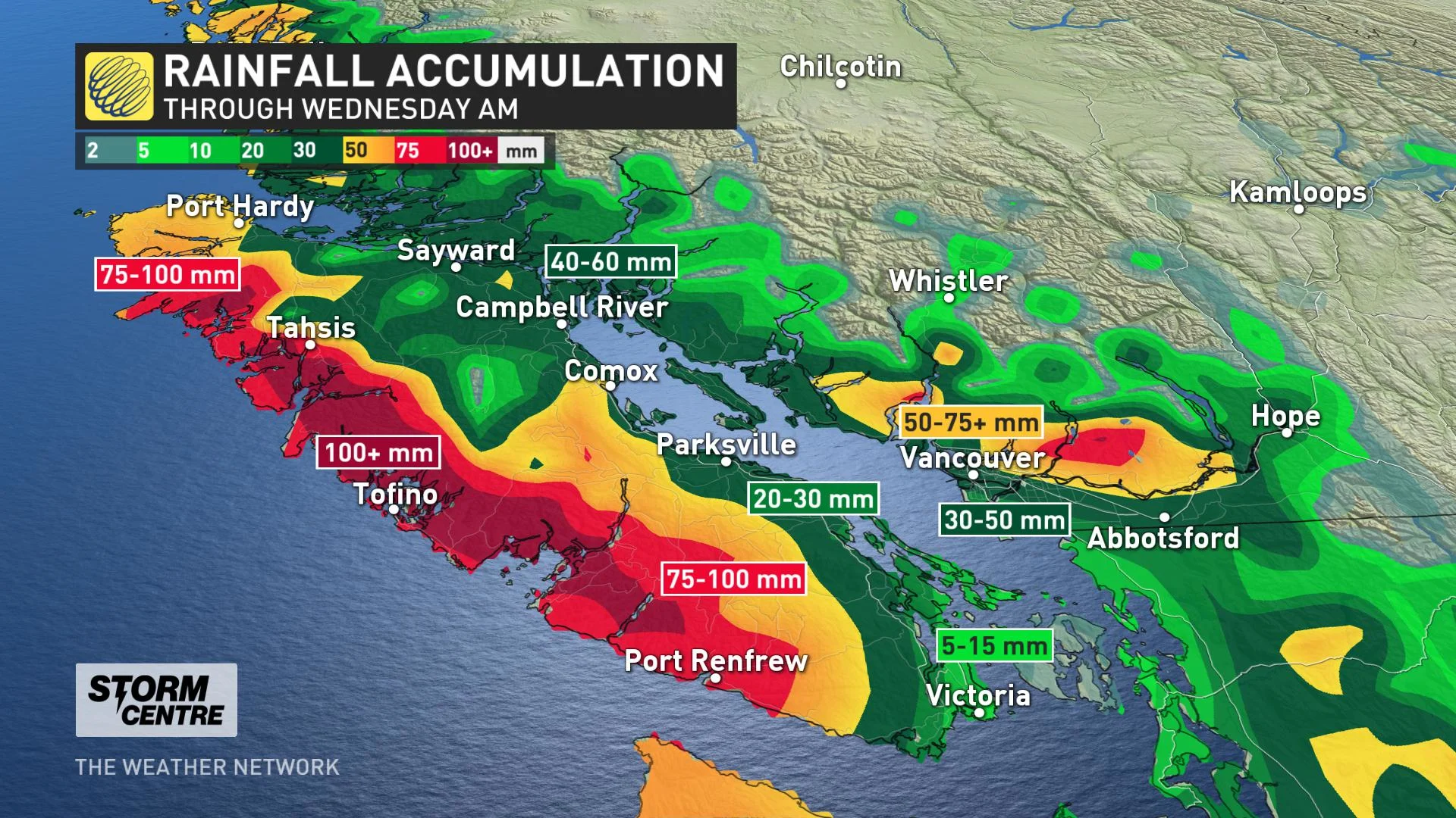
Rainfall totals will be excessive for western Vancouver Island, where 75-100+ mm of rain is possible through Wednesday morning, while parts of the Lower Mainland may see 50-75+ mm of rain. Because of this, localized flooding is possible. A rainfall warning is in effect for western Vancouver Island.
"Given the already saturated ground and additional heavy precipitation, there will be the risk of flooding or landslides in already compromised areas," says Weather Network meteorologist Nadine Hinds-Powell.
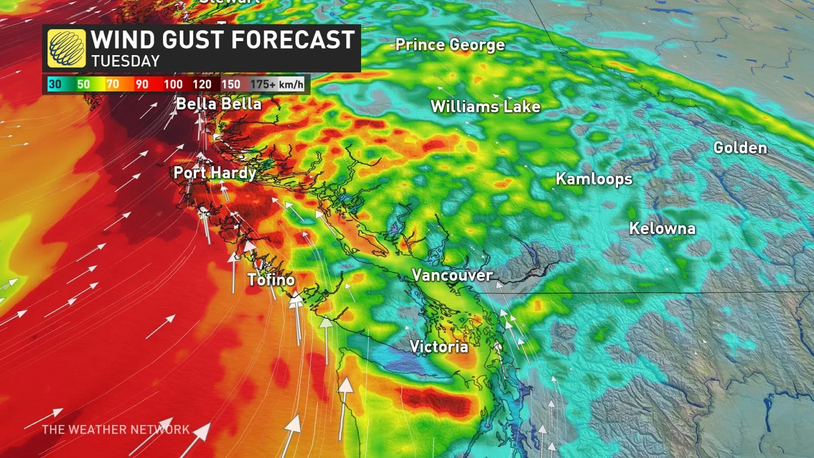
The strongest wind gusts will exceed 100 km/h for the northern coast, and north and west Vancouver Island coastal areas Tuesday morning. In the afternoon, the winds will be strongest in the Strait of Georgia, Juan de Fuca and coastal areas of the Lower Mainland, with gusts of 80-100+ km/h through the straits.
Victoria is expected to see 70-80 km/h wind gusts, while the Vancouver area may see blustery gusts reaching 60 km/h. There is the potential for widespread power outages, damage and interruptions to ferry services. Far-reaching wind warnings are in place along the coastal regions.
As well, snowfall along the coast will eventually push into the Interior Tuesday night and continue through Wednesday morning.
Even higher elevations of parts of the Lower Mainland may see a brief change over to snow with heavy precipitation rates and temperatures marginally sitting above the freezing mark in the afternoon and evening hours Tuesday.
Freezing levels will drop Tuesday, reaching 800 metres and then rising to 1000 metres on Wednesday, holding steady at that level into Friday. This could make for even more difficult travel beyond the mountain passes.
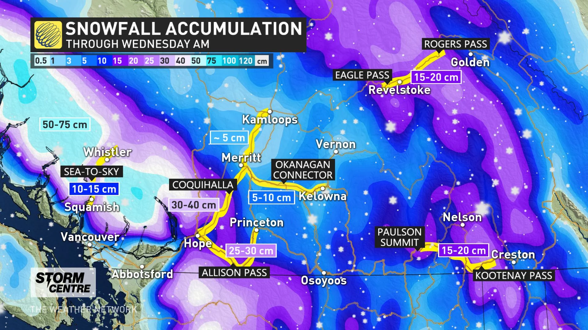
Snowfall warnings are in effect for Kinbasket and North Columbia, where 15-20 cm of snow is expected through Tuesday morning.
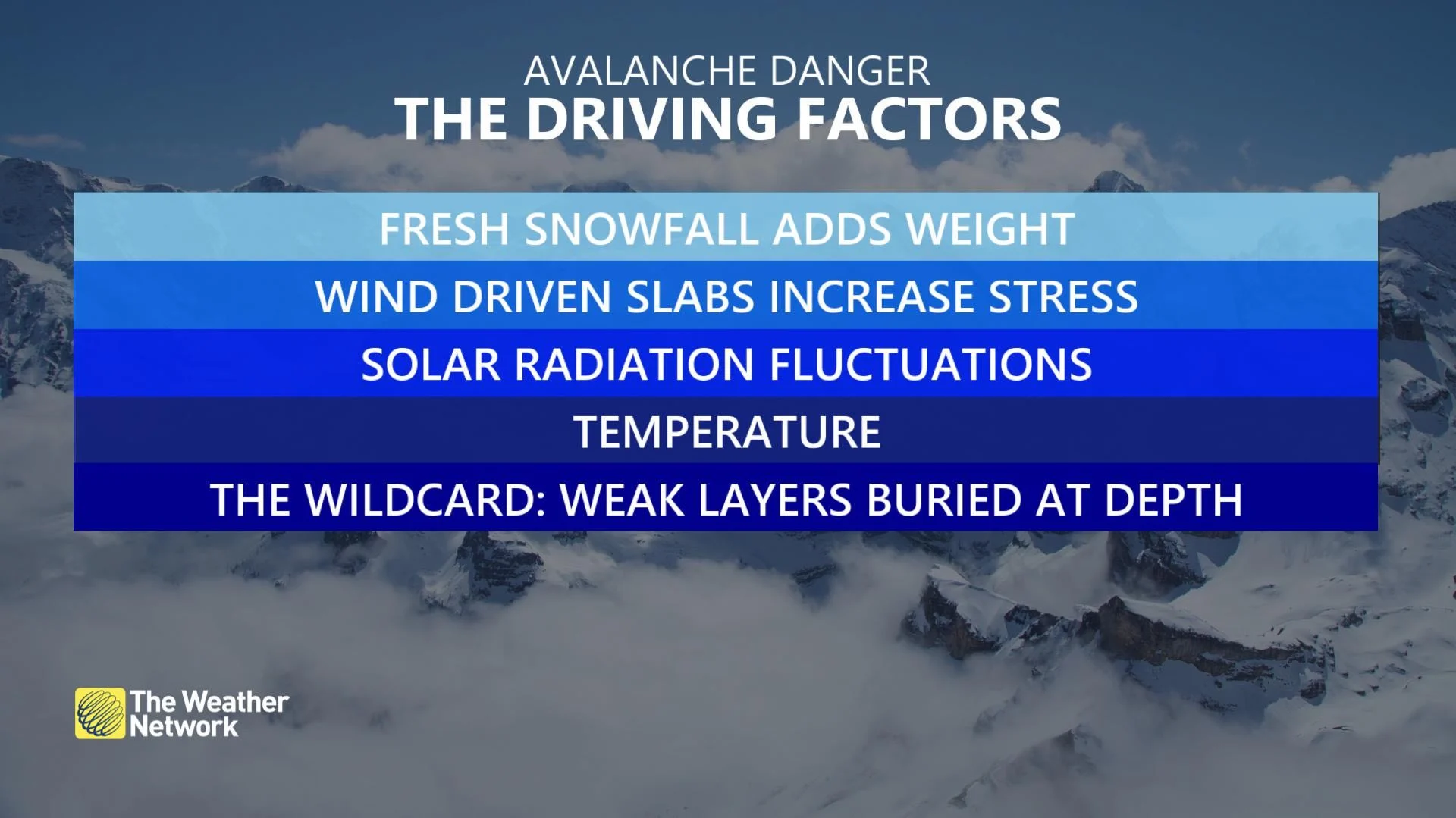
Due to the additional accumulations of snow, the avalanche danger remains elevated across the mountain passes -- with most peaks been designated with 'considerable' ratings.
Conditions will improve Wednesday morning, allowing for a brief drying out before the next system moves in for Friday.
HEAVY RAIN AND SNOW MAKING DANGEROUS AVALANCHE CONDITIONS IN THE BACKCOUNTRY
STORM TOTALS BY WEEK'S END
In all, seven-day rain totals of 100-150 mm are expected for the South Coast by the end of the week, with 50-75 mm forecast for Victoria and as much as 200-300 mm for western Vancouver Island.
Some of the hardest-hit mountain passes are likely to pick up as much as two metres of snow by the end of this week.
Temperature-wise, daytime highs will be near to slightly-below seasonal for coastal areas, and near seasonal for the Interior and east, with no sustained Arctic air in sight.
Stay tuned to The Weather Network for the latest forecasts.