Soaring temperatures to exacerbate flooding in B.C., Alberta
Meteorologist
Tuesday, May 1, 2018, 7:42 PM - Which weekend will summer show up for this year? A typical Canadian joke, but a persistent pattern (and stubborn ridge) is set to redevelop and usher in waves of above seasonal temperatures. Is 30°C once again on the table? I won't give that away, just yet.
WEATHER HIGHLIGHTS
- Lack of active weather across the west – temperatures remain seasonably warm, but surge to well above normal values once again next week
- The prairies are searching for their first 30°C of the season, so closely tracking the warm anomaly that'll push temperatures awfully close come next week
- Flooding, ice jams, and wildfire activity ongoing across the west, and watching a significant warm-up in the alpine next week across B.C. and Alberta (heightened flooding concerns)
- Drought conditions and fire threats ongoing across southern Saskatchewan and Manitoba, with no relief in sight
Keep on top of active weather by visiting the ALERTS page.
An eerily similar pattern that unfolded at the end of April is set to make an encore performance; a massive ridge of high pressure was responsible for the first 30°C in Canada. Luckily, other Canadians that are just coming off an abysmal April are seeing their first taste of summer-like temperatures – a welcome relief for parts of Ontario and Quebec!
But, what's to come for the west? I present to you some stellar news. May as a whole is expected to be above seasonal for western Canada. Look at the latest map drawn up by Dr. Doug, our long range guru:

How unusual is the next week or so in terms of a temperature anomaly? A unique was to view this is using weather balloons.
TRACK THE RESILIENT RIDGE BUILDING IN
This is a perfect opportunity to geek out, a little. Diving into some climatology, let's pick a location near the heart of the predicted ridge of high pressure. We're going way up, approximately 3 km above sea level, for Spokane, Washington. This will make for a decent proxy.
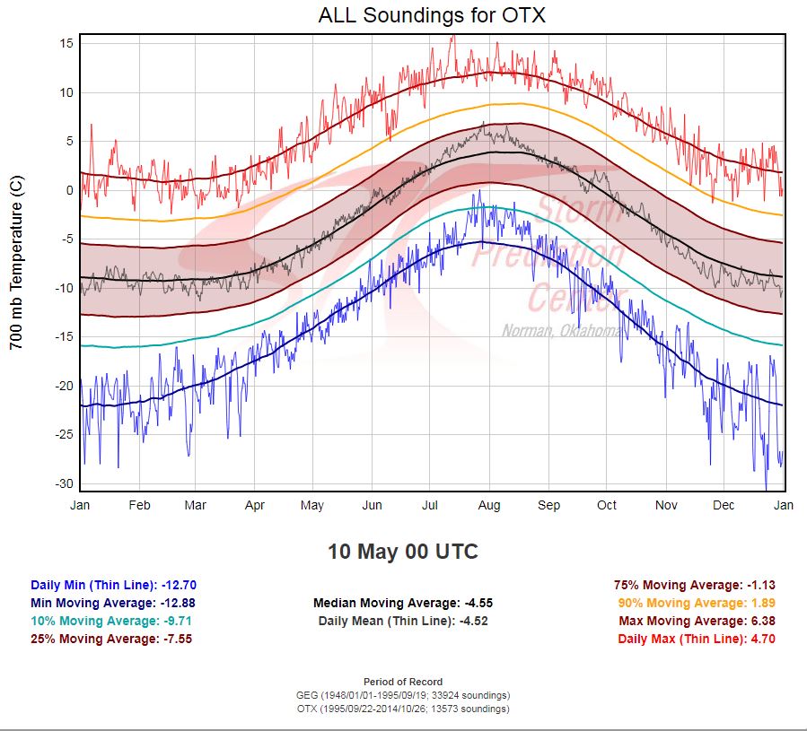
To read this graph, look at the date along the x-axis, and every sounding (weather balloon launch) is plotted for the given day, giving a range of recorded values. The daily max 3 km temperature is 4.7°C (bottom right) for the balloon launch on the evening of May 9th (next Wednesday). Not a monthly record for 3 km temperatures, as the squiggly red line shoots above 10°C a few times, especially towards the end of the month, but it could very well set a daily max record. If you want to play around with some soundings, here is the link for your enjoyment.
Did I lose you? Enough of this – it's time to check in on what impact the record-breaking temperatures last week brought to our mighty snowpack locked up in the mountainous regions of B.C.
Take a guess, how much of a dent did the anomalous air mass bring?
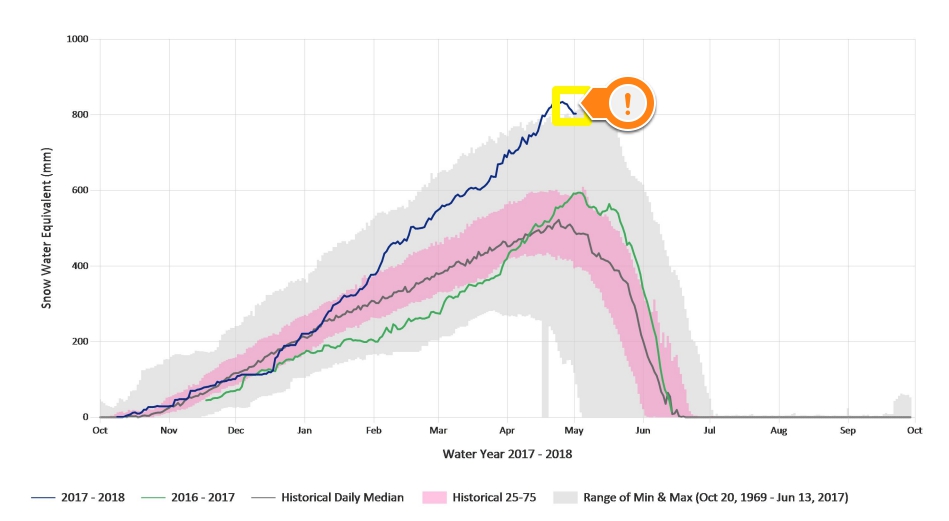
Prepare to be shocked. Using Mission Creek (Kelowna) as the proxy...
Barely a blip.
Yeah, you're reading that graph correctly. Just a few percent of the snowpack has melted at higher elevations (1780 m), but we've clearly reached peak, as evident at the maximum values observed at the end of April. Roughly 800 mm of snow water equivalent (total water content of the snowpack) is still locked up in the mountains lurking over the Okanagan. For some locations, two seasons worth of snow is still set to melt off the highest alpine regions.
We're far from being in the clear from spring flooding, especially with the forecast warmth in May.
In some extreme cases the snow monitoring station (snow pillow) at Misison Creek has recorded a completely depleted snow pack by early May (light grey shade). It's always dangerous trying to predict how the snowpack will respond to weather conditions, but it may be possible for this station in particular to still have snow by early July...quite the feat.
That's it, for now. An update will be provided later with a refined look at our 30°C prospects for next week.