La Niña sidelined, which means reduction in winter impact
Visit this Fall Forecast Guide to the Season for the Fall Forecast, Winter Weather Preview and more.
Meteorologist/Science Writer
Monday, September 12, 2016, 9:00 PM - What's going on with La Nina Watch 2016? Based on the waffling of the weather and ocean in the equatorial Pacific, a potential La Niña has been officially sidelined, with forecasters anticipating normal to near-normal conditions throughout the coming winter.
Forecasters with NOAA's Climate Prediction Center have officially called off their La Niña Watch, based on what they are seeing in the equatorial Pacific Ocean and what their climate models are showing for the coming seasons.
According to NOAA research scientist Emily Becker's latest entry on the Climate.gov blog:
Since the demise of the big 2015-16 El Niño in April, the tropical Pacific has been loitering around in neutral… and now forecasters think it’s likely to stay that way through the winter. For now, we’re taking down the La Niña Watch, since it no longer looks favorable for La Niña conditions to develop within the next six months.
It's like 2014 in replay
Two years ago, the Pacific Ocean was on-board for developing an El Niño, and early forecasts showed the potential for one that could far surpass the super El Niño of 1997. Yet, it was held back.
Throughout 2014, while ocean heat migrated into the central and eastern equatorial Pacific, the atmospheric side of the pattern - the so-called Southern Oscillation - stubbornly refused to cooperate. Rather than transitioning from the normal ocean-spanning "conveyor belt" of winds to the broken-down pattern of multiple circulations that characterizes an El Niño (shown below), the normal "conveyor belt" persisted.
|
|
|
| Typical ENSO-neutral (left) and El Niño (right) conditions over the Pacific Ocean. Credit: NOAA | |
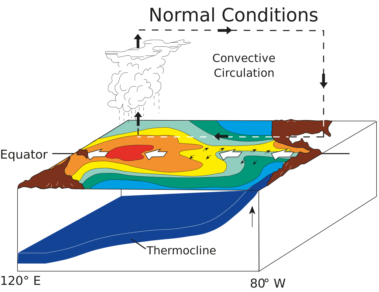

Since the full cooperation of both the ocean heat of El Niño and the shift in the Southern Oscillation are needed for this pattern (hence, why it is called "ENSO"), conditions remained neutral in the Pacific throughout 2014, despite the forecasts from earlier in the year.
It wasn't until the atmosphere finally fell in line, in early 2015, that the El Niño officially got underway.
Now, following the demise of Super El Niño 2015, forecasters were anticipating a fairly quick transition, to at least a weak La Niña, by the end of October. While warmer waters have quickly retreated from the eastern and central equatorial Pacific, which supported the forecast, we're seeing the same kind of weak commitment from the atmosphere that we saw in 2014.
|
|
|
| Typical ENSO-neutral (left) and La Niña (right) conditions over the Pacific Ocean. Credit: NOAA | |
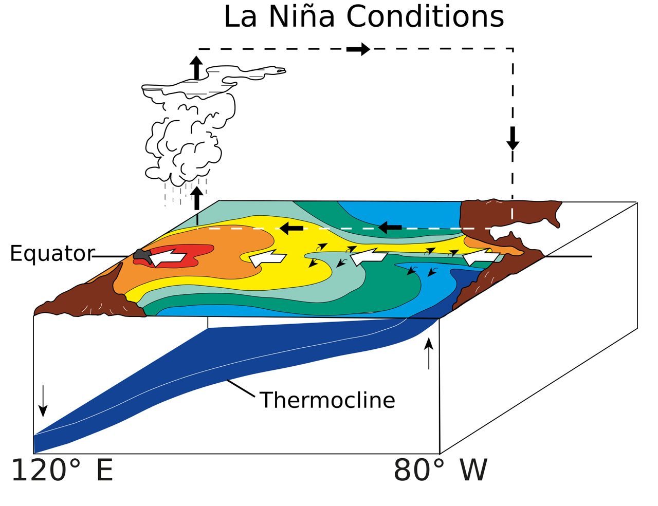
So, instead of stronger winds across the ocean surface, which would support La Niña development, the winds have remained more normal, or ENSO-neutral.
According to the ENSO Forecast, from the International Research Institute for Climate and Society (IRI):
During early September 2016 the tropical Pacific SST (Sea-Surface Temperature) anomaly was close to -0.5oC, near the weak La Niña threshold. However, only about half of the atmospheric variables indicate borderline or weak La Niña conditions. Although the upper level winds in the tropical Pacific are somewhat suggestive of La Niña, the lower level winds remain near average. The Southern Oscillation index and the pattern of cloudiness and rainfall in the equatorial Pacific are close to the La Niña threshold, but still only in the cool-neutral range. The collection of ENSO prediction models indicates SSTs retreating from currently near-La Niña levels toward cool-neutral from the present through fall and into winter.
Based on computer model forecasts, the average of all the results show that temperatures in the central Pacific - the Niño 3.4 region, which is typically used to gauge El Nino and La Nina events - look to be warming slightly throughout the months to come. Is this just a delayed response, like we saw in 2014, which will eventually lead to the development of a La Niña by late 2017 or early 2018? Will we rebound right back into another El Nino (as happened in the mid-1960s and in the early-2000s)? Or, instead, will we simply persist in neutral conditions for some time, as something of a reset, before the pattern starts up again?
For further developments, stay tuned for NOAA's October update.
What does this all mean?
When a La Niña develops in the Pacific Ocean, it can have an impact on North American weather during the following winter and spring. Since the temperature shift in the eastern Pacific during a La Niña is not as dramatic as it is during an El Niño, however, it takes a fairly strong La Niña pattern to really have a strong influence on our winter.

Comparison between September 4, 2015 and September 6, 2016, showing the temperature differences in the Pacific Ocean. Credit: Environment Canada
As Dr. Doug Gillham wrote in his preview of The Weather Network's Fall Forecast:
The current pattern is not expected to progress all the way to a strong or even moderate La Niña event during the upcoming fall and winter. While weak La Niña or even neutral conditions do impact global weather patterns, this pattern is not as dominant in its influence as is a strong El Niño or strong La Niña event.
Therefore, temperature patterns in other regions (such as the North Pacific and North Atlantic) will be more influential during the upcoming seasons, especially during the winter. A striking feature in the above map is the large region of very warm water (relative to normal) off the west coast of Canada and south of Alaska. This feature, as well as the relatively warm water in the Atlantic Ocean to the east of North America, were keys in our search for analogue years ... which can offer clues on the dominant weather patterns for the upcoming fall and winter seasons.
So, as far as things are looking now, don't count on having La Niña around this winter.
Instead, focus more on the warmer temperatures in the northern Pacific - what has been casually referred to as "the Blob" - and the recurrence of the "Ridiculously Resilient Ridge" over the west coast, which is typically associated with it. This, along with similar warm temperatures in the northern Atlantic, will play greater roles in how the upcoming seasons play out.
![]() FALL IS HERE: After a hot, hot summer what can Canadians expect from fall? Find out on The Weather Network’s Fall Forecast. Premiering September 12, 2016, at 9PM ET #FallForecast
FALL IS HERE: After a hot, hot summer what can Canadians expect from fall? Find out on The Weather Network’s Fall Forecast. Premiering September 12, 2016, at 9PM ET #FallForecast
Source: Climate.gov | CPC/IRI