Hurricane Matthew aborts loop, ends chance at rare binary
Meteorologist/Science Writer
Saturday, October 8, 2016, 6:10 PM - Once on track for a strange looping path and a rare binary interaction with Tropical Storm Nicole, Hurricane Matthew is now projected to weaken as it heads out to sea and these two storms appear to miss each other by at least a few days. Here's the science behind what's going on with these storms.
This story has been updated, as of Saturday evening, to reflect the latest forecast tracks for these storms.
An aborted loop-de-loop track for Matthew?
As of the latest look at the track of Hurricane Matthew, provided by forecasters with NOAA's National Hurricane Center at 5 p.m. EDT on Saturday, it appears as though this storm has aborted its attempt at the strange looping track it was forecast to follow over the next several days.
Now having made landfall in South Carolina, and having weakened to a Category 1 Hurricane, Matthew is projected to weaken significantly over the next two days. After that, likely starting on Monday, the post-tropical remnant of this storm will link up with passing cold front to the north, and be drawn northeast, towards the Maritimes.
![]() FALL IS BACK: After a hot summer what can Canadians expect from fall? Find out with The Weather Network’s 2016 Fall Forecast | FORECAST & MAPS HERE
FALL IS BACK: After a hot summer what can Canadians expect from fall? Find out with The Weather Network’s 2016 Fall Forecast | FORECAST & MAPS HERE
Why this sudden change in Matthew's track? It has to do with what's going on high up, with the winds blowing around 10 kilometres above the surface.
In the two animations below, the top shows the wind patterns - surface and 10 km - as of Friday afternoon. The bottom one shows how things have changed over the past day.
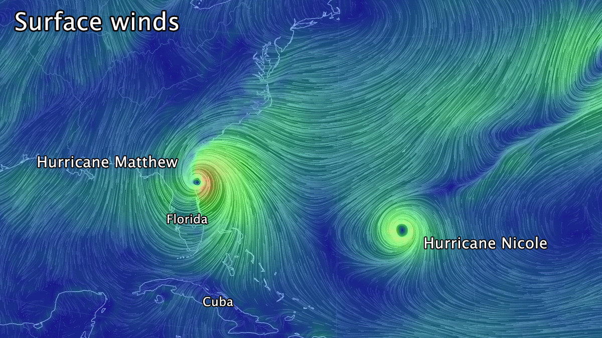
Surface and 250 mb wind fields, as of 2 p.m. EDT, Oct 7. Image credit: earth.nullschool.net. Animation by S. Sutherland
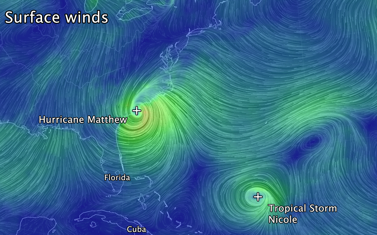
Surface and 250 mb wind fields, as of 11 a.m. EDT, Oct 8. Image credit: earth.nullschool.net. Animation by S. Sutherland
As shown in the second panel of the animations, on Friday there was a very strong curved flow just to the northeast of Matthew - a jet streak - which would have steered Matthew on a curving path back towards an eventual second encounter with the Florida coastline, but as of Saturday, the flow at the entrance to the jet streak is blocking Matthew. It's still likely to head out to sea, and it's path is projected to curve more southward as it does so, but for the most part, the jet streak has left Matthew behind.
While it would have been fascinating to watch Matthew pull this rare maneuver, there is a sense of relief now, as Florida - with the damaged already inflicted there on Matthew's first pass - will not have to experience a second bout from this storm in the days to come.
No dance for Matthew and Nicole
While once there was a chance for these two storms to interact with each other, due to a phenomenon known as the Fujiwhara effect, as of the latest forecast track update, the dance cards of these two have been officially cleared.

A composite forecast track map for Hurricane Matthew and Tropical Storm Nicole. Original images taken from NOAA NHC's interactive 5 p.m. EDT, Oct 8 update. Composite by S. Sutherland.
With Matthew now weakening and likely to be swept up in the normal flow of weather starting on Monday, by that time, Nicole will still be far, far to the southeast.
Thus, while previous forecast tracks gave an excellent chance for these two to come close enough to interact with each other, now the chance appears to be lost.
What would have happened, if the forecast for Matthew's loop-de-loop track had played out?
In general, tropical cyclones tend to keep their distance from one another. If we anthropomorphize them, it really comes down to a survival technique, because if two storms happen to form near each other, the one with slightly more favourable conditions typically ends up swallowing the other one whole.
Every once in awhile, however, storms will be forced together, by interaction with land or due to the pattern of the upper level winds. In these cases, they experience what's called the Fujiwhara effect.
Named for the scientist who published the first scientific research on the phenomenon, Japanese meteorologist Sakuhei Fujiwhara, this effect causes storms in close proximity to orbit one another, like binary stars, and eventually either be torn away from each other or merge into one.
What's happening here?
As the winds spiral cyclonically around each storm - counter-clockwise in the Northern Hemisphere or clockwise in the Southern Hemisphere - the flow between them blows in opposite directions. If the storms get close enough, around 1,400 kilometres apart, this sets up a swirling pattern between them, as shown in the example below:

Satellite views of Severe Tropical Storm Parma and Typhoon Melor, from October 6, 2009. Credit: MODIS Rapid Response Team at NASA GSFC
With this anti-cyclonic swirling pattern, it promotes sinking air which keeps the space between the storms relatively clear of cloud, but it also acts as a focal point to steer the storms into a clockwise binary orbit.
If the storms remain at that 1,400 km distance, their interaction won't be very strong, and they'll just wander away from one another as the upper level wind pattern guides them. If they close the distance to around half that, however, their orbit will speed up, drawing them closer. Once they get within 300 km of each other, that's usually the end of the dance. The stronger of the two will either erode the weaker one, due to wind shear, to the point where the weaker one dissipates, or the two cyclones will actually merge into one.
Unless the forecast changes drastically again, either due to the storms re-strengthening by passing over warmer water, or due to the upper level flow changing once again, it doesn't look like we'll be seeing any of this behaviour from these two storms.
Sources: NOAA National Hurricane Center | Hong Kong Observatory


