Five things you need to know about Thursday
Digital Reporter
Thursday, June 19, 2014, 7:09 AM - Wondering what you missed overnight or what you can expect for the day ahead?
Here's your weather briefing for Thursday, June 19.
1. Clean-up continues in Angus, Ontario
An EF-2 tornado, with wind speeds up to 220 km/h, ripped through the community of Angus Tuesday night, damaging about 100 homes.
![]() EXTENDED ACTIVE WEATHER COVERAGE: Tune in to The Weather Network for live updates on the summer storms in your area. Our team of reporters and meteorologists in the field provide you with the most accurate and up-to-date coverage.
EXTENDED ACTIVE WEATHER COVERAGE: Tune in to The Weather Network for live updates on the summer storms in your area. Our team of reporters and meteorologists in the field provide you with the most accurate and up-to-date coverage.
Officials are working as quickly as possible to assess the damage and get people back home. Another update from police officials will be provided Thursday afternoon.
#Angus tornado aftermath: "It's a miracle no one was hurt." https://t.co/iuzIumujKy #onstorm pic.twitter.com/cURRkgvOvn
— The Weather Network (@weathernetwork) June 18, 2014
Tornadoes in Canada
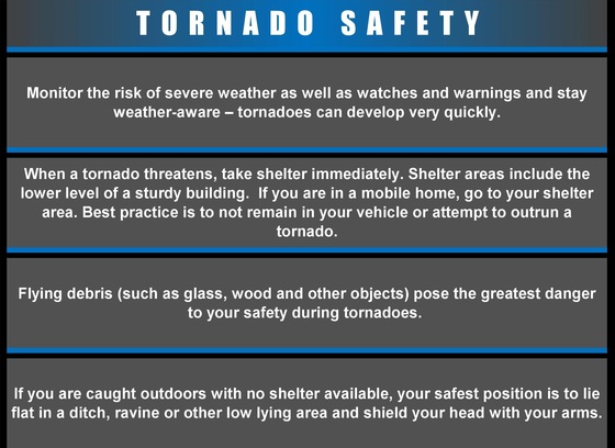
We tend to know a lot about tornadoes in the United States and what areas are more prone to them but, when it comes to tornadoes in Canada, the knowledge isn’t as widespread.
With information about severe weather at our fingertips, it has become increasingly easy for Canadians to obtain and spread knowledge of severe weather.
Check out this detailed analysis about what tornadoes are, where tornadoes occur most in Canada, some of the research being done on tornadoes in Canada, and how we can stay safe.
3. Spirits lifting in soggy southern Alberta
Weather conditions are slowly improving and the rain is gradually easing, lifting spirits of southern Albertans who feared a repeat of last year's devastating floods.
Overland flooding was reported in Claresholm Wednesday, but an evacuation centre that had been set up overnight was closed by the evening hours.
According to Lethbridge Mayor Chris Spearman, the river flow forecast has improved and things are beginning to look better.
![]() ANALYSIS ON 2013 FLOODING IN ALBERTA: Two must-read, expert analysis columns from The Weather Network meteorology department. READ: Why So Much Rain? | ALSO: It Could Happen Again
ANALYSIS ON 2013 FLOODING IN ALBERTA: Two must-read, expert analysis columns from The Weather Network meteorology department. READ: Why So Much Rain? | ALSO: It Could Happen Again
It was on this day one year ago when heavy rainfall in Alberta triggered one of the worst natural disasters in Canadian history.
The historic flooding prompted 32 states of emergency declarations across the province as the flows of three major rivers rose to almost 10 times their normal rates.
Fire Chief Cornforth says good news from river forecast centre and peak flows looking to be approximately 1,800 cubic metres per second.
— City of Lethbridge (@LethbridgeCity) June 18, 2014
4. Severe thunderstorm threat for the Prairies
A slow moving low pressure system will continue to bring rain to parts of the southern Prairies on Thursday.
In addition to the rain, there's a chance for severe thunderstorms to fire up across central and southern Saskatchewan as well as southern Manitoba.

5. Pattern change ahead for western Canada
June has gotten off to a rather chilly start across much of central and western Canada while above-seasonal temperatures have dominated much of Quebec and parts of Atlantic Canada
"However, we are now in the midst shift in the weather pattern which will bring some significant changes in the temperatures across the country," says Weather Network meteorologist Doug Gillham. "This change will be most noticeable across the Prairies where near to above seasonal temperatures are expected starting on Friday and continuing much of time through the end of the month."
Want to know more? Check out Dr. Gillham's latest article here.


