Attention turns to 'significant' weather system arriving December 24
Meteorologist
Thursday, December 18, 2014, 5:52 PM - A very interesting weather pattern and change has our full attention at The Weather Network and it should have your attention, too. Especially as the timing of the system is expected to have an impact on Christmas Eve and the holiday season.
The system will have a significant impact on travel – both road and air – and should have those in the affected areas thinking about early preparedness ahead of the busy holiday season. Here are some tips to your to get yourself ready coming Christmas storm.
THE HOLIDAYS
Meteorologists have been watching the long range pattern for some time now leading into Christmas and what has been very prevalent to us is that we are expecting a big change in the weather pattern across Canada with the main change occurring right over the Christmas holidays. We know during this pattern change, we can expect some stormy weather so the big questions are: when exactly will this occur and what kind of stormy weather is this going to create? So there are two stories to tell which are the storm and the temperatures.
On The Weather Network’s social media accounts, #SantaBomb is trending as a term attached to the timing of the system and, of course, in reference to the meteorological term 'weather bomb'. That said; true weather bombs rarely develop over land, and are often attached to the rate of intensification (a drop of at least 24 millibars in 24 hours).
![]() RELATED: What is a 'Weather Bomb'? Expert explains.
RELATED: What is a 'Weather Bomb'? Expert explains.
With this system, the story will not be so much around the intensification, but rather the potential for it to be a dangerous, disruptive and damaging storm.
DECEMBER 2014
Let’s start with what December temperatures have been like… Most of Canada has experienced a mild beginning to December relative for this time of year. Most of December will likely average to near or above normal for temperatures across the country. There is an end in sight, though, to the mild temperatures.
What the map below depicts: Temperature anomalies (how above or below normal the temperatures were) for the past two weeks via WeatherBELL.

Whether you’re happy about it or not, temperatures will be on the decline and that change will begin to happen through Christmas and really set itself into place between Christmas and the New Year.

As mentioned previously, this pattern change will go hand in hand with a big weather maker over Christmas for eastern Canada. There is still quite a bit of uncertainty amongst the forecast weather models as to what exactly this storm (or storms) is/are going to look like when they happen. A couple of the long range weather models have become quite aggressive with the potential storm system bringing dangerous weather and travel conditions Christmas Eve into Christmas Day. The GFS and ECMWF forecast models on Wednesday afternoon outlined a very stormy Christmas for Ontario and Quebec with an intense low pressure system impacting the area as shown below in the first image. However, the Canadian forecast model has a different solution with a run-of-the-mill low pressure system affecting Ontario and Quebec then leading to a strong east coast low to impact Atlantic Canada going into Boxing Day (as shown in the second and third images below).
What the map below depicts: GFS forecast model painting a stormy solution for Ontario and Quebec on Christmas Day

What the map below depicts: The Canadian forecast model's solution showing less of an impact on Ontario and Quebec on Christmas Day.

What the map below depicts: The Canadian forecast model showing a big east coast low to develop to impact Atlantic Canada on Boxing Day.

Herein lies the forecast dilemma: We know this large pattern change will be accompanied by intense, stormy winter weather but at this point in time, it’s difficult to say how exactly it will pan out. As many folks will be travelling over the next week, especially Christmas Eve through Boxing Day, you will definitely want to keep checking back with our latest forecasts. This is something we will monitor with every new run of the weather models.
NEXT PAGE: SO, WHO IS GETTING THE WHITE CHRISTMAS?
WHITE CHRISTMAS?
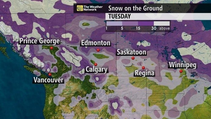
Ahh, another dilemma. We, in Canada, are in a fairly different position with regards to our snow cover than we were at this time last year. As of Wednesday morning, Edmonton, Saskatoon, Ottawa and Montreal all had more than two centimetres of snow on the ground. It’s normal for Vancouver and Victoria to have little to no snow on the ground at this time of year but places like Calgary, Winnipeg, Halifax and St. John’s have trace to no snow on the ground as of Wednesday morning. Many are wondering if they will see a white Christmas and we’re certainly working away at it. From Alberta to Manitoba, there is essentially one more chance to add some snow to the snowpack (or grass-pack?) before Christmas morning and at this point, there doesn’t seem to be too much snow with the system. We will see a few centimetres of snow with this clipper system that will occur before Christmas but it remains to be seen, at this point, whether or not it will be enough to boost some folks’ snow totals to get them a white Christmas!
What the map below depicts: Interpolated data of the snow on the ground across western Canada as of very early Wednesday morning.
As for eastern Canada, well, the big, looming potential for a Christmas storm will certainly be the deciding factor in whether or not we get a white Christmas across eastern Canada cities. We do have a storm system set to bring heavy snow to New Brunswick Wednesday night and Thursday but it’s mostly rain for Nova Scotia, parts of P.E.I. and eastern Newfoundland. Those in Toronto, Halifax and St. John’s don’t have any snow on the ground right now (maybe just some left over piles at the end of the driveway from shovelling or a sad looking snowman). This Christmas Eve to Boxing Day storm, who it impacts, and when it occurs, will essentially decide whether or not we see a white, or stormy, Christmas.
What the map below depicts: Interpolated data of the snow on the ground across eastern Canada as of very early Wednesday morning.

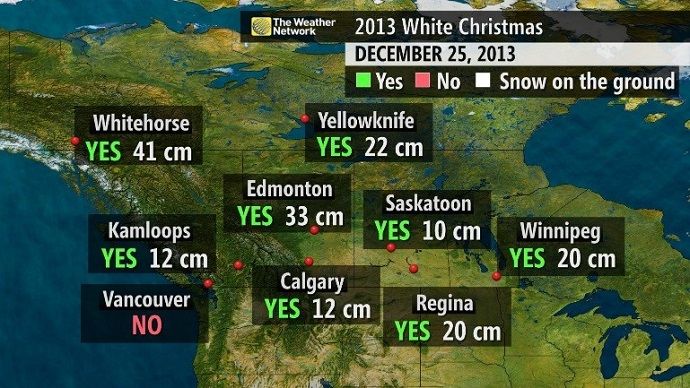
Here’s a look at some of the “snow on the ground” numbers we had Christmas morning across Canada last year and whether or not these cities had a white Christmas:

THIS WEEKEND
Some good news! If you’re travelling anywhere this weekend anywhere from Alberta to Newfoundland, weather should not play a role in travel delays. There aren’t any major storm systems in the aforementioned region for Saturday or Sunday. There is the risk of a bit of light snow in the Prairies Saturday but it will be light and passing, likely not accumulating too much. British Columbia will be our more active region of the country this weekend. The continuous parade of moisture we’ve been seeing, typical to this time of year in B.C., will carry on through the weekend with a couple of more storm systems impacting the province. The deluge coastal B.C. experienced earlier this month is not expected this weekend but the wet pattern is continuing. Throughout the weekend, 30-60 mm of rain is in the forecast for Victoria and Vancouver areas with higher rainfall amounts as we increase in elevation (60-75 mm) and those are totals from Friday night through Sunday night. Winds will also be gusty throughout the weekend. Higher elevations and ski resorts in British Columbia and along the Rockies in Alberta can expect accumulating snow from Friday to Sunday. We may see some travel delays due to rain and wind in British Columbia and be aware of driving conditions through the mountain passes due to changeable precipitation types.
Doug (@gtaweather1) & Jaclyn (@jwhittalTWN) will have more details on the #SantaBomb in The Long Ranger, every :26 past the hour on TV.
— The Weather Network (@weathernetwork) December 17, 2014

