Supercharged storm produces awe-inspiring shelf clouds in Saskatchewan

The time-lapse video and stunning images were captured by The Weather Network’s Kyle Brittain while storm chasing in Saskatchewan on June 16.
Thunderstorms can evoke anything from fear to fascination, but for storm chasers, they're what they live for.
That's why when the forecast called for severe thunderstorms in southern Saskatchewan earlier this week, our Alberta video journalist and storm chaser, Kyle Brittain, hopped in his Weather Network vehicle and drove east with camera in tow.

Courtesy: Kyle Brittain
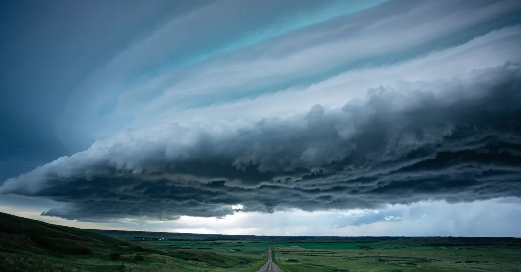
He captured these remarkable shelf clouds on June 16 just south of Craik, Saskatchewan. For those curious minds, shelf clouds are a type of accessory cloud (arcus) that are often attached to cumulonimbus clouds and mark the leading edge of the rain-cooled air/outflow from convective showers or thunderstorms.
They form when the wedge of cool air under the storm forces air upwards and can appear convective (bubbly) or laminar (due to stable air at that level).

Courtesy: Kyle Brittain
The laminar-looking shelf clouds (such as this one) are perhaps the most impressive, as they appear smooth and sculpted - especially when they are multi-tiered. This layered appearance results from stratified air of differing relative humidities being forced up the slope of the cold wedge.

Courtesy: Kyle Brittain
And for an even better look, don't miss the time-lapse video above!