Dozens of Sask. communities grapple with torrent of spring flooding
Inflows into at least one Saskatchewan river are as high as a 1-in-200-year event, due to rapid melting of a larger-than-average snowpack, the province's Water Security Agency says.
That's leading to widespread flooding in many areas in the northwest, northeast and east-central parts of the province.
While some flooded areas are seeing the waters recede, others aren't expected to reach their peak flows for another four to six days, said Leah Clark with the Water Security Agency.
"We've experienced a late, rapid thaw and higher-than-average snowpack, combined with late spring snowstorms, and it's creating significant runoff in northwestern and northeastern Saskatchewan," Clark told media during a briefing on Monday afternoon.

A barn sits in a flooded yard on Sunday in the Tisdale area. (Thomas Simon/CBC)
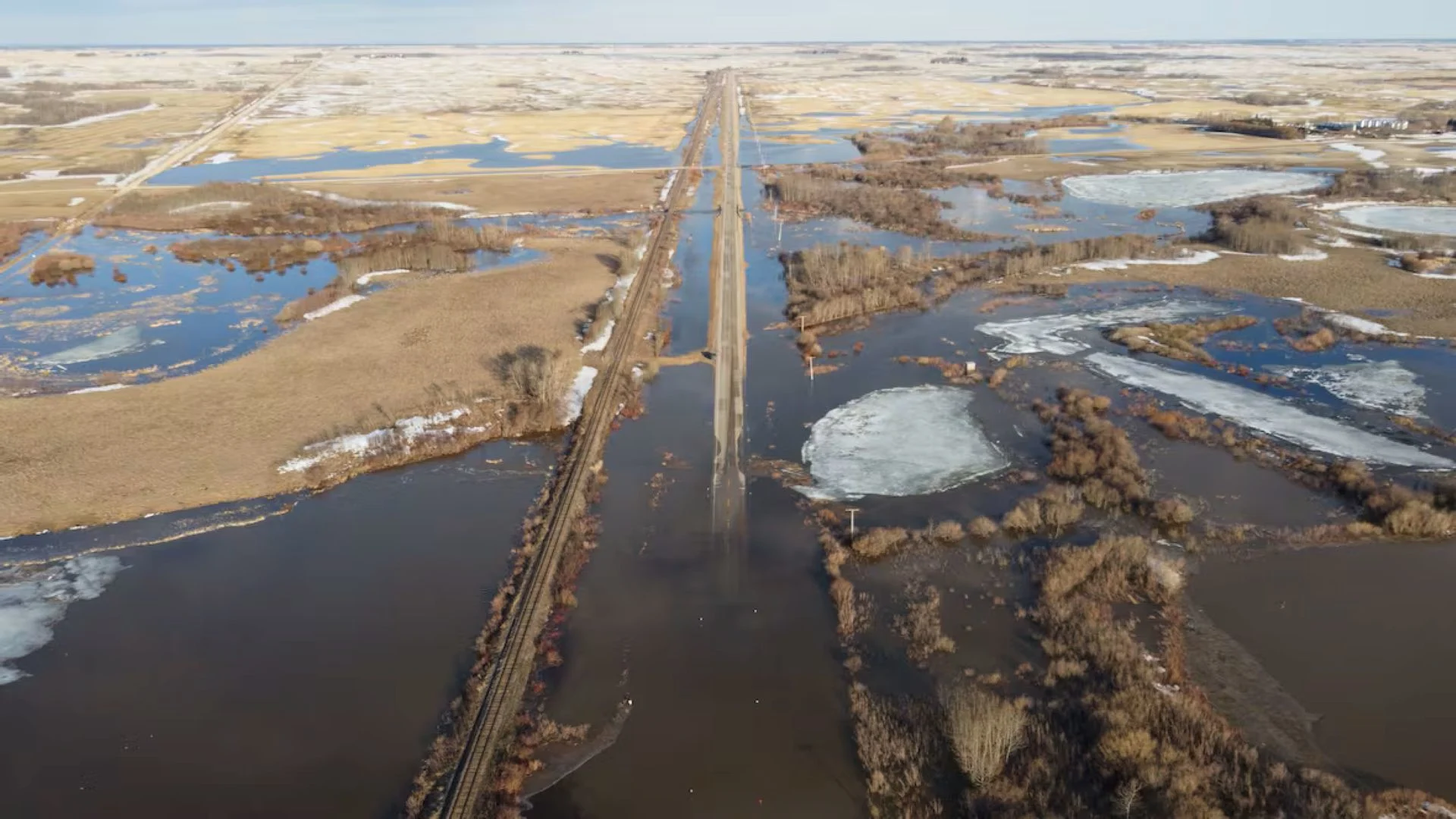
Over the weekend, high flows were observed in the northern portions of the Quill Lakes basin, the headwaters of Carrot River and parts of the Assiniboine River basin, Clark said.
Inflows into the Carrot River range as high as a 1-in-200-year event near Armley, she said. In the Quill Lakes basin, some tributaries are seeing at least a 1-in-50-year event.
That has resulted in local states of emergency due to flooding and road closures caused by washouts throughout the region.
Joyce Drummond, the mayor of Quill Lake, said she spoke with some 80-year-old residents of the community who told her they've never seen flooding this bad. Quill Lake is about 165 kilometres east of Saskatoon.

Parts of the Village of Quill Lake, Sask., were experiencing flooding on Monday. (Will Draper/CBC)
The lift station, which pumps away the village's sewage as well as its stormwater, started getting overwhelmed on the weekend. By Sunday, it started backing up on some of the streets, Drummond said on Monday.
Basements in some homes started flooding, and residents couldn't keep up.
"[Residents say they] can't run our sump pumps to full capacity because it just pumps it out, comes back in," Drummond said.
Land scorched by fire now flooded
In the northwest, the small community of Patuanak is cut off from the rest of the province for the second time in less than a year.
This time it's due to water instead of fire.

Footage from a drone shows flooding near Buchanan, just north of Good Spirit Provincial Park lake, on the weekend. (Submitted to CBC by Colin Pasiechnik)
But the circumstances are all intertwined, said Candyce Paul, the emergency management co-ordinator for English River First Nation.
Giant amounts of snow fell onto land that was burned last summer by wildfire. As the snow melts, there are no living trees, root systems, or muskeg to absorb the water.
The result is that the only highway into the community is washed out in a half-dozen places.
"So it's like there's brand new lakes and rivers all along that road," Paul told Blue Sky host Leisha Grebinski on Monday. "And then the debris from those burns is washing up against the culverts and blocking them as well, so that's compounding the problem."
The road closed on Friday afternoon, leaving about 160 people who had left the community for the weekend or for the day unable to return. They are being supported in communities including Saskatoon, Meadow Lake and North Battleford, Paul said.

If the road stays closed for many days, there is the option to bring in supplies by air, as the landing strip at the airport is open for small planes, she said.
Local states of emergency
The Saskatchewan Public Safety Agency said there are 15 active local emergencies in the province, with the possibility of more on the way.
Some communities, such as the Town of Foam Lake in east-central Saskatchewan and the RM of Meadow Lake in the northwest, began declaring local states of emergency as early as April 21.
In Foam Lake, the water has receded and the situation is stabilized, but officials are monitoring conditions as there could be a second wave of flooding, said Jeff DeDekker with the SPSA.
More communities declared local emergencies on the weekend, including the RM of Shellbrook in north-central Saskatchewan and the Town of Arborfield, RM of Lake Lenore and RM of Lakeview in the northeast.
SEE ALSO: Infamous disaster scenario can rapidly unfold, study finds
Flooding widespread
Caitlyn Villeneuve farms in the Quill Lake area, about 150 kilometres east of Saskatoon.
"At first, I was quite shocked because when I heard that it was starting to flood, I actually didn't quite believe it until I saw it," she told Morning Edition host Adam Hunter on Monday.

One of the places that is washed out on Highway 918, the only road access to the community of Patuanak, in northwest Saskatchewan. (Submitted to CBC by Candyce Paul)
"Then it was really surreal. I was like, 'Oh my gosh.'"
Some roads in the Tisdale and Melfort areas were affected by flooding on the weekend.
Craig Clark spent most of Monday morning looking for an escape route in case he needed to leave his home about 23 kilometres from Melfort.
He said about 90 acres of his land is flooded.
"It doubled in size within the two hours we were in town yesterday and then this morning," said Clark.
He said water was continuing to build as of 1 p.m. CST.
Melfort area resident Shelley Vanderbyl said she left to go to church Sunday morning and noticed some water on the road, but when she was heading home it was a lot worse.
"But now when I've come back, it's washed out quite a bit. … It doesn't look too safe," she told CBC on Sunday.
Sydney Bassingthwaite, owner of Lady of the Paws Pet Services, had to make an impossible decision and shut down her grooming salon Monday.
It happened after the salon, located on her family farm about 32 kilometres from Tisdale, was submerged in water.

Craig Clark said that his pasture is flooded after water doubled in size overnight near his home 23 kilometres from Melfort, Sask. (Submitted by Craig Clark)
"It just got out of control," Bassingthwaite said.
"We have an access road to the farm and that started flooding over. And since we've owned the farm for the last 15 years, that has never happened."
Road closures
Highway crews were out all weekend assessing damages, repairing roadways and ensuring culverts were open, said Highways Minister Kim Gartner.
He encouraged anyone planning to travel to check the Highway Hotline for the most up-to-date information before they travel.
As of 11 a.m. CST, Highway 5 is affected by flooding for much of its length. At Watson, there's water over the road just west of the town and a local detour is in place.
Continuing east, speeds are reduced in two locations heading to Quill Lake due to water over the road. Then, the highway is closed for a 100-kilometre stretch from Wadena to Canmore.
Also in east-central Saskatchewan, flooding on Highway 49 west of the Kelvington turnoff has closed one of the lanes.
Highway 310 near Foam Lake is closed south of Highway 16 due to a washout.
There are numerous road closures in areas east of Prince Albert. Near Carrot River, Birch Road is closed due to flooding east of Highway 23.
Near Armley, both Highway 35 and Highway 335 are closed due to water over the highway.
Just west of Choiceland, motorists are advised to reduce their speeds on Highway 55 due to water on the road.
North of Prince Albert, there's water on Highway 2 south of Spruce Home. North of that, Highway 355 is closed in both directions where it meets Highway 2.
Highway 791 to Paddockwood also has water on the road and caution is advised.
Further north, Highway 916 is closed west of Highway 2 due to a washout.
Where Highway 936 meets Highway 2 there are are road closures due to a culvert washout.
Thumbnail courtesy of Colin Pasiechnik via CBC.
This article, written by Hannah Spray, was originally published for CBC News. Contains files from The Morning Edition, Blue Sky, Colleen Silverthorn, Thomas Simon and Aliyah Marko-Omeni.