The science behind Ontario’s training storms

Training storms are known to cause severe flash flooding in a short period of time. Meteorologist and storm chaser, Mark Robinson, takes us through the last training storms event that occurred on July 9.
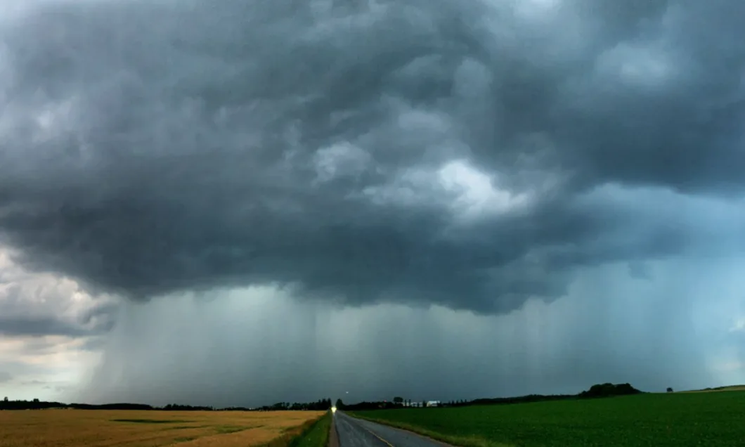
Tree shred is not something you want to have landing on the car, especially when there’s a river cascading down the road beneath the vehicle. It’s the bits and pieces that are torn off trees in the howling winds of a downburst generated by a strong thunderstorm. It might seem harmless at first because it’s just leaves and small branches. The problem comes when you can’t see the really big branches that are about to follow their small brethren onto the roof of your car.
Even worse, I knew that this was just one downburst in an ongoing series. Seaforth, Ontario was sitting right in the middle of a thunderstorm birthing ground and I was sitting in the middle of the town.
Seaforth sits on the “west coast” of Ontario, about 25 kilometres from the shore of Lake Huron. It’s not a large town, but it has a grocery store, a main drag, homes, and assorted other businesses that cater to the agricultural sector that’s so important to Ontario. Right now, the main street is undergoing major rebuilding and it’s not easy to just drive through. It’s not unlike so many other small communities in the southwestern part of the province.
But, for weather, it’s in far more rarified company. The town sits right under the lake breeze line that sets up lake Huron in the summer. The line can move further inland, but on the day that I arrived, the boundary between the cold air off the lake and the warm, humid air that had been pulled up from the Gulf of Mexico sat right over the town.
A boundary is a trigger point for summer thunderstorm development and can be the dividing line between cold and warm air, or dry and warm air, etc. It just has to be a quick change over a short distance. Ontario gets interesting boundaries in the form of lake breeze fronts, so even on those hot, humid summer days that make you want to either hide inside or go swimming all day, we can get thunderstorms.
RELATED: Flooding, trees down after intense storms slam GTA
The problem with these storms is that because they fire-up on lake breezes, the warm, humid air that the storms feed on isn’t swept out of the area by a moving cold front. Instead, the boundary stays in one place and the storms can continually fire on it. These are known as training or back building storms.
That’s exactly the situation that Seaforth found itself in on July 9th, 2020. Storms began to fire on the lake breeze boundary off Huron right over the town and as each one matured and moved northeast, a new cell fired over the town. This meant that the town was being continuously battered by howling wind and rain.
Training storms are often sparked by the outflow boundaries (cold air dumped out of a collapsing storm, acting as a miniature cold front) of upstream storms, but often in Ontario, this continual back building can be helped along by the stationary lake breeze front. With the already very humid airmass that Ontario tends to have, these storms can produce huge amounts of water.
Which is exactly what happened in Seaforth.
At one point I’d parked the car in a parking lot overlooking a small house with a steel shingle roof. For a few minutes, the wind subsided and I’d gotten out of the car to check for damage in the area. As the next storm built overhead, I knew that I likely had only moments before the next downburst hit. I was lucky to get two. As the wind howled up again, the small house withstood the blast and sheets of water skated off the steel roof in waves that reminded me of being in the midst of a hurricane.
The continuous battering of the storms meant that flash flooding and tree damage began to build up in the town and even as I moved to get more of a look at the storm in the town, branches lay scattered everywhere and literal rivers flowed down the streets. As is typical in these training storms, the continuous downpour overwhelmed the sewers and flash flooding began to leave gigantic puddles that streamed into each other along the sides of the roads. Visibility shut down to the point that I swore I was suddenly back in the midst of a winter storm.
This even went on for hours in the town, every storm adding a bit more water and a bit more damage. By the time that the storms finally began to move away at the onset of darkness, the town had received almost 80 mm of rain had fallen.
This wasn’t a first for Seaforth, nor will it be the last. As the summer of 2020 continues to blanket southern Ontario with heat and humidity, these slow-moving, high precipitation.