Roads washed out, people displaced and homes threatened in Sask.
This year, April showers did not bring May flowers. But April snows did bring May flows.
The widespread flooding in Saskatchewan can mainly be attributed to rapid melting of a higher-than-average snowpack, experts say.
April was the winter that didn't end, with a series of massive snow dumps one after the other, piling more moisture on top of an already higher-than-average snowpack.
RELATED: Dozens of Sask. communities grapple with torrent of spring flooding

A barn sits in a flooded yard on Sunday in the Tisdale area. (Thomas Simon/CBC)
On the first weekend in May, temperatures rose and it all started to melt.
"And of course, when that happens, instead of water flowing off the land slowly, it's coming very quickly," Chuck Deschamps, a retired biologist, told Blue Sky host Leisha Grebinski.
"If it's crop land, you can think of it as almost like pavement. The water doesn't infiltrate because the ground is frozen."

Parts of the Village of Quill Lake, Sask., were experiencing flooding on Monday. (Will Draper/CBC)
By Monday, flooding resulted in 15 active local emergencies in the province. And the Saskatchewan Public Safety Agency said there's the possibility of more on the way.
The northwest, northeast and east-central parts of the province are the worst affected, with road washouts closing highways and isolating some communities, such as Patuanak in northwest Saskatchewan.

Footage from a drone shows flooding near Buchanan, just north of Good Spirit Provincial Park lake, on the weekend. (Submitted to CBC by Colin Pasiechnik)
The province's Water Security Agency has issued four advisories since April 18 due to high flows and ice jamming.
As of Monday, a high-flow advisory remained in effect covering a broad swath of the province — from near Buffalo Narrows in the northwest to near Yorkton in the southeast.

One of the places that is washed out on Highway 918, the only road access to the community of Patuanak, in northwest Saskatchewan. (Submitted to CBC by Candyce Paul)
Inflows into the Quill Lakes basin, an area where rising waters are a longstanding issue, are at least at a 1-in-50-year level, a Water Security official said on Monday.
And flows into the Carrot River range from a 1-in-25-year event in some areas to a 1-in-200-year event, near Armley, Sask.

Deschamps said the fast spring melt is the major factor in the flooding, but not the only factor.
Wetlands provide "flood protection services at no cost to the public" by slowing the runoff, but areas continue to be lost every year to agricultural, industrial and urban developments, he said.
"That water has to go somewhere when you drain it off the land, to use that land for other purposes," Deschamps said. "And sometimes not a lot of thought is given to where that water is going."
SEE ALSO: Infamous disaster scenario can rapidly unfold, study finds

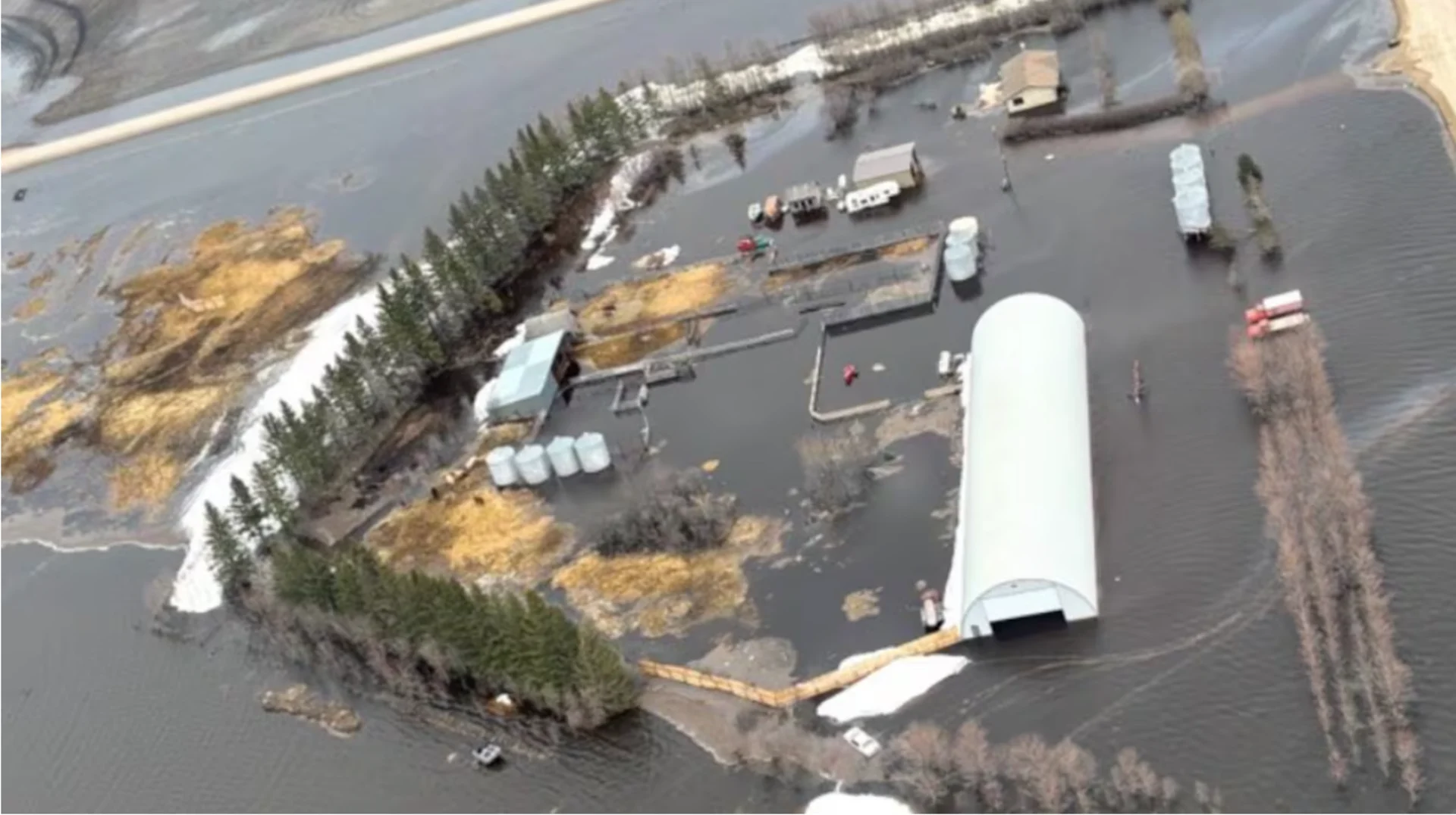
An aerial photo shows a farm in the Quill Lake, Sask., area that's been inundated by floodwaters. (Photo submitted to CBC by Josh Odelein)
Colin Whitfield, an associate professor in the school of environment and sustainability at the University of Saskatchewan, also pointed to the spring runoff as the main cause of the flooding — and echoed Deschamps's comments that it's not the only factor.
Wildfires over the last few years in northern Saskatchewan increased the land's vulnerability to flooding, Whitfield told CBC's Jeremy Warren.
"And so the vegetation that normally would be taking up moisture and releasing it back to the atmosphere is maybe not at its full extent, as some of those large fires have rolled through and that vegetation is just maybe starting to regrow," Whitfield said.
He said the province also seems to be transitioning from a drier phase back into a more wet phase — so some areas that were in drought conditions are suddenly inundated. That is pushing some stream systems "to the limits," Whitfield said.
Saskatchewan residents should expect to see more of these extreme weather conditions in the future, said retired biologist Deschamps.
"This isn't something that is a one-off," he said. "We need to do a better job of managing our water and how that's coming off the land, and think about it in a cumulative fashion, not just where it comes off one quarter [section], but how it affects the entire system and in the watershed."
WATCH: Three tips to protect against flooded basement damage
This article, written by Hannah Spray, was originally published for CBC News. Contains files from Blue Sky and Jeremy Warren.