Temperatures fell 35+ degrees in hours behind the ‘Great Blue Norther’

One of the most extreme temperature changes ever observed occurred on Nov. 11, 1911
One of the most powerful cold fronts on record sent temperatures plummeting more than 30 degrees in a matter of hours on Nov. 11, 1911.
Some cities broke their record-high and record-low temperatures on the same day as the unprecedented setup swept across the central United States.
DON’T MISS: What is the polar vortex? How it’s responsible for dangerous cold
Powerful cold fronts are common from the Prairies to the Plains as weather systems develop and roll through the region. Some of those fronts, often dubbed Blue Northers, can usher in some of the most extreme temperature swings the weather can produce.
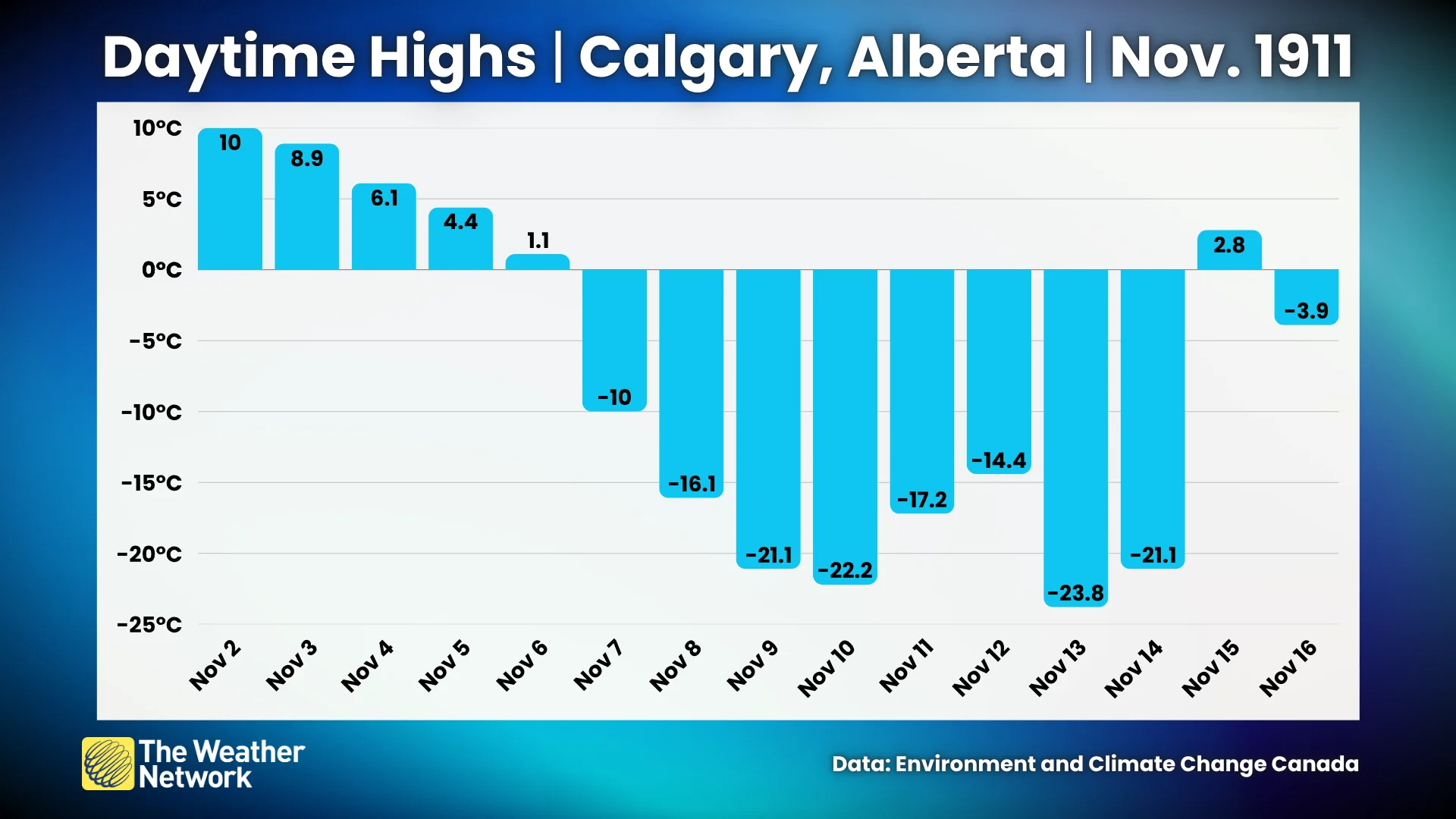
An outbreak of Arctic air began pushing across the Prairies on Nov. 6. The high in Calgary dropped from 1.1°C that afternoon to -10.0°C the following day. Each day saw successively colder readings, with a frigid low of -29.4°C reported by Nov. 10.
The trough responsible for that surge of bitterly cold air contributed to the formation of a powerful low-pressure system over the southern U.S. Plains.
Strong winds spiralling around the rapidly developing storm dragged unseasonable warmth into the region. Daytime high temperatures on Nov. 11 reached 29.4°C in Tulsa, Oklahoma, and 25.0°C in St. Louis, Missouri.
That same counterclockwise flow also sped up the Arctic cold front racing down from Canada. Winds gusted 80-100+ km/h as the frigid air raced southward, sending temperatures in the region plummeting at an astounding rate.
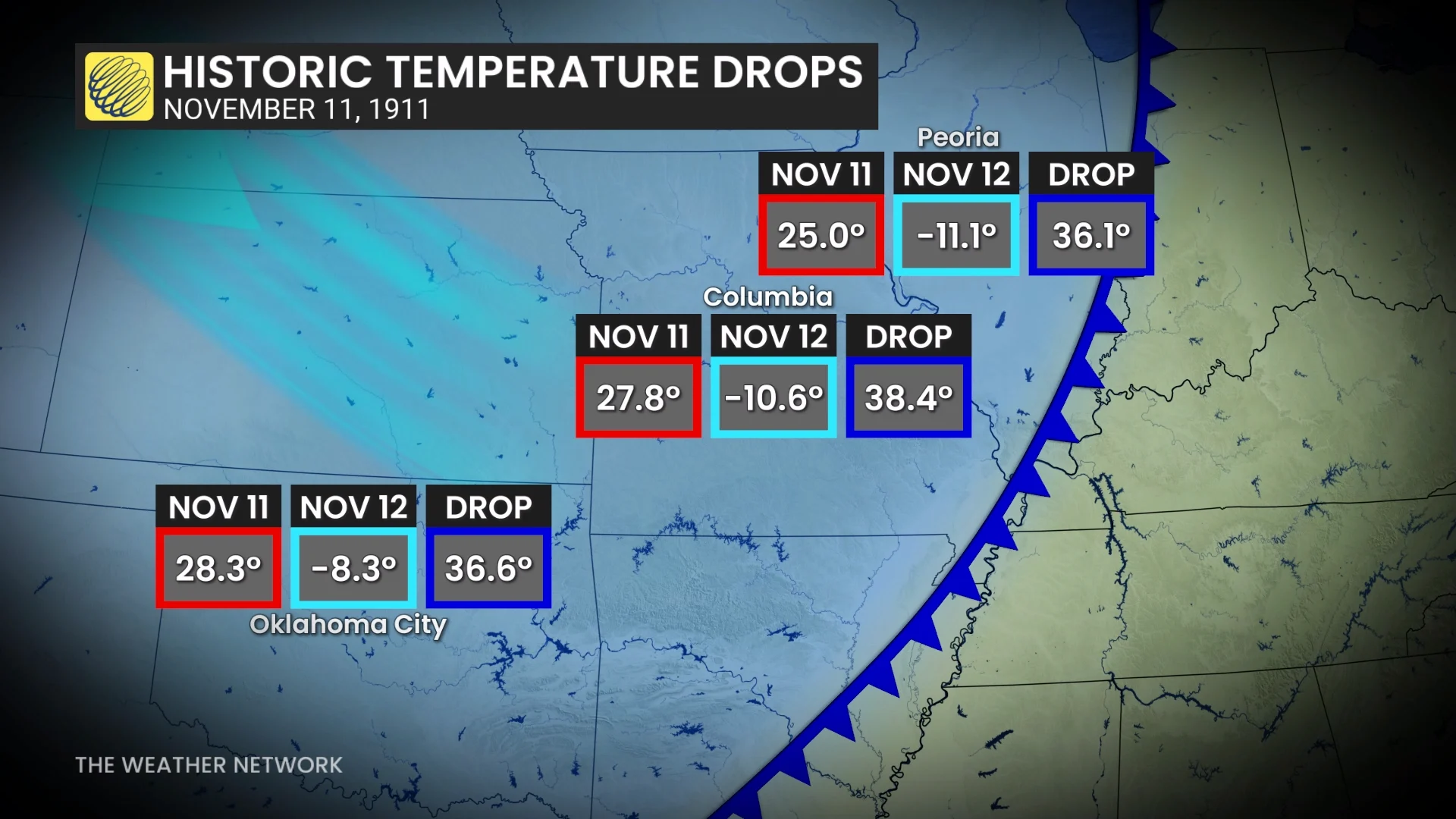
Readings fell 35-40 degrees across the hardest-hit areas. Columbia, Missouri, saw a temperature drop of 38.4°C between the afternoon of Nov. 11 and the morning of Nov. 12. Oklahoma City saw a 36.6°C change in less than 24 hours, setting both the record high and record low for the day.
The extreme temperature change stirred up some equally destructive conditions. Numerous tornadoes touched down in the warm and humid air drawn north by the low-pressure system. Rescue crews reportedly had to comb through tornado debris in heavy snow and blizzard conditions just hours later.
How does that compare to some of the extreme temperature changes recorded in Canada?
A fierce Chinook wind blowing through southern Alberta sent the temperature in Pincher Creek soaring from -18.9°C to 3.3°C in just one hour between 12:00 a.m. and 1:00 a.m. on Jan. 27, 1962. This was possibly one of the most dramatic warmups ever observed.
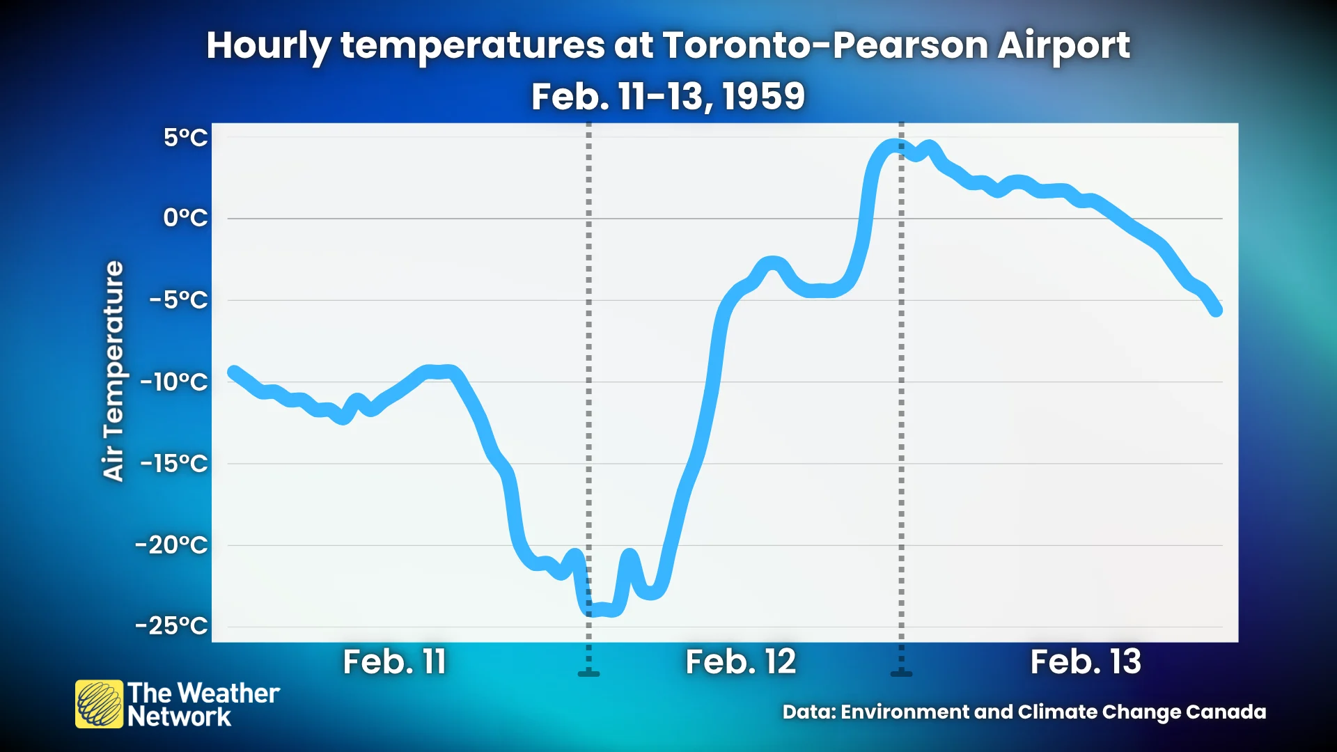
Toronto once experienced a tremendous temperature swing in both directions during the middle of Feb. 1959.
Frigid air moving settling over the Great Lakes on Feb. 11 sent late-night temperatures down to nearly -25°C. Soon after, southerly winds wrapping around a low-pressure system west of Toronto sent temperatures soaring through the day Feb. 12, peaking at nearly +5°C by the following night.