Highway closures with ‘little notice’ possible as wildfires burn in B.C.
The latest on the wildfires:
Thousands of properties in B.C. remain under evacuation order Monday, including entire cities and communities in the Interior.
Multiple buildings have been damaged by two separate fires in the Kelowna area.
Some of the largest and most dangerous fires are burning near Kamloops.
The Coquihalla Highway remains closed between Hope and Merritt.
Drivers are being warned highways through the Interior could shut down with little to no notice because of wildfires. Non-essential travel is discouraged to keep evacuation routes open for locals.
For a full list of evacuation orders and alerts, visit Emergency Information B.C.'s Twitter feed.
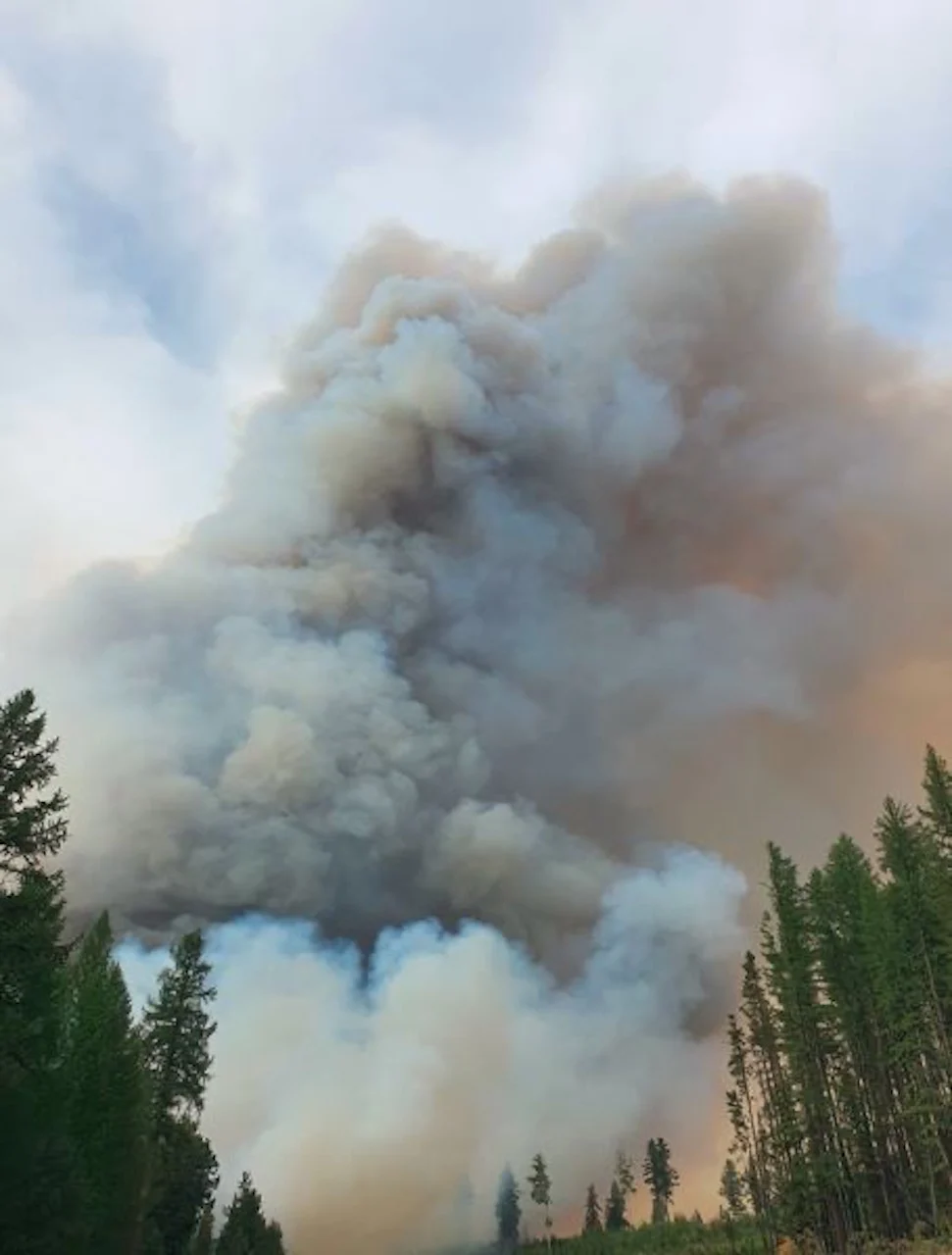
Thousands of properties remain under evacuation order Monday after "exceptional" high winds fuelled dozens of wildfires across B.C., sending flames barrelling toward entire communities.
Hundreds fled their homes under smoke-filled orange skies on Sunday as evacuation orders were issued, one after the other. Most of the newest evacuation orders are in the Kamloops area, where some of the of the largest and most dangerous fires in the province are burning.
There are at least a dozen wildfires in the Kamloops Fire Centre district, including the Lytton, White Rock Lake, Tremont Creek and Sparks Lake fires.
Officials confirmed Monday the White Rock Lake fire has "significantly damaged" multiple buildings in the quiet Killiney Beach area, north of Kelowna on the edge of Okanagan Lake.
THIS WEEK'S FORECAST: Despite a tease of rain, fires and dense smoke will persist in B.C.
There has also been "limited damage" in West Kelowna, to the south, due to the separate Mount Law fire.
"Due to evolving conditions crews have not been able to complete a full assessment of structure damage. More information will be provided to property owners and the media as it becomes available," reads an email from Central Okanagan Emergency Operations.
To the northwest, more than 730 properties west of Kamloops remain on evacuation alert due to the sudden growth of the Tremont Creek wildfire. Dozens more homes in the Cherry Creek area, south of Highway 1, are under evacuation order.
The Okanagan Indian Band near Vernon, B.C., is still ordering residents of about 80 properties to leave immediately if they have not yet done so. The North Okanagan was one of several parts of the Interior left in a dark red twilight in the middle of the afternoon on Sunday, after thick smoke blocked out the sun.
Care home residents and acute care patients in Armstrong, Lillooet, 100 Mile House, Merritt and West Kelowna have been relocated to other communities due to wildfire activity, according to Interior Health.
The health authority says families are being contacted with details of their loved one's temporary location, contact information and ongoing care.
In all, based on the Sunday count, the province said more than 6,600 properties had been ordered evacuated. Another 16,000 were on alert.
FAST-GROWING FIRE BURNING NEAR WEST KELOWNA
Another out-of-control wildfire, first spotted Sunday between Peachland and West Kelowna, just north of a major highway, forced nearly 500 evacuations in the Glenrosa neighbourhood of West Kelowna within hours.
Evacuation orders issued overnight also affect homes in Peachland.
Fire crews say "exceptional" winds quickly pushed the newly ignited Mount Law fire to eight square kilometres — an area twice the size of Stanley Park.
"The fire quickly grew and became, quite frankly, a nightmare for our community," West Kelowna Fire Chief Jason Brolund said Monday in an interview.
"Like nothing I've ever seen before," he continued. "The fire moved in almost every direction and really acted like a snake. It surrounded an area of our community and then came down the hill towards the homes that were closest."
Carly Beaton had to leave West Kelowna for Vernon, just a week after she was evacuated to West Kelowna from her North Okanagan home in Fintry, due to the White Rock Lake wildfire.
"You could see the flames coming over the mountain and everybody was leaving," Beaton said Monday to Chris Walker, the host of CBC's Daybreak South, about what happened in West Kelowna's Glenrosa neighbourhood over the weekend.
Elsewhere in the Interior, entire communities remain on evacuation alert due to separate fires: the City of Armstrong, the City of Merritt and the District of Barriere. Combined, the communities are home to more than 12,000 people.
The Coquihalla Highway, a major link between the Interior and the Lower Mainland, remains closed between Hope and Merritt. The road had to be shut down after two fires on either side of the highway merged into one, according to the wildfire service.
Drivers who took the mountain route Sunday while it was still open drove past flames snapping at the edge of the pavement.
WATCH NOW: DAY TURNS TO NIGHT IN OKANAGAN DUE TO SMOKE BLOTTING OUT THE SUN
Officials are imploring tourists to stay away from Interior communities impacted by wildfires.
"If you're planning to travel to those areas, it's time to change your plans," Public Safety Minister Mike Farnworth said, suggesting travellers go elsewhere in the province.
There are nearly 270 active wildfires burning provincewide. Incessant heat and high winds have made the situation worse for weeks, but the B.C. Wildfire Service expects a break in the weather on Monday.
"We are looking at some reprieve. The heat wave is behind us. We're looking at precipitation, even, in the southern Interior, which has been a consistent area of concern for us this season," fire information officer Erika Berg told CBC Daybreak South in an interview Monday.
"We are anticipating some cooler temperatures, which will aid our fire suppression efforts, and [the] winds will not be as intense as they were last night," she said.

Air quality in the Kamloops and North Okanagan areas remained poor Monday. Cooler weather is expected to help with the haze from smoke.
A total of 1,513 wildfires have burned a total of 7,667 square kilometres of land since April 1, accounting for an area twice the size of Metro Vancouver.
"This is not a normal fire season by any measure," B.C. Minister of Forests, Lands, Natural Resource Operations Katrine Conroy said during a press conference Monday.
The wildfire service said the total area burned is about seven times greater than the 10-year average.
BE PREPARED FOR A WILDFIRE EVACUATION WITH A 'GRAB-AND-GO' BAG, HERE'S WHAT TO PACK:
Anyone placed under an evacuation order should leave the area immediately.
Evacuation centres have been set up throughout the province to assist anyone evacuating from a community under threat from a wildfire.
To find the centre closest to you, visit the Emergency Management B.C. website.
Evacuees are encouraged to register with Emergency Support Services online, whether or not they access services at an evacuation centre.
Thumbnail courtesy of BC Wildfire Service.
This story was originally published by CBC News on August 16, 2021.