Highway washouts continue in Haida Gwaii, northwest B.C. amid heavy rainfall
Sections of highway have been washed out in Haida Gwaii and northwest B.C. in the aftermath of an atmospheric river system that soaked the area earlier this week.
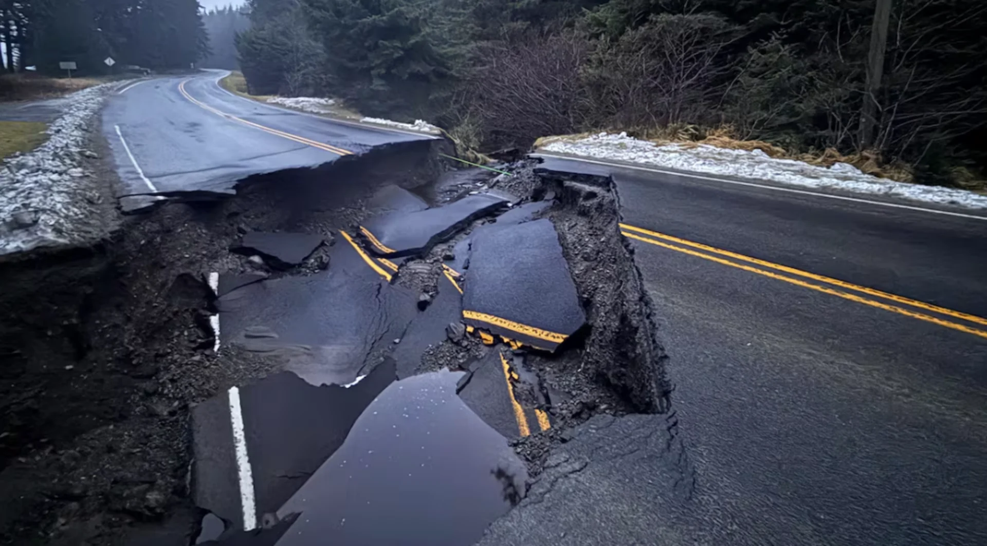
The Haida Nation warned of "extreme flooding" in Haida Gwaii on Monday, as a stretch of the crucial Highway 16 was shut due to a major washout.
DriveBC said the highway is closed between Lawnhill Road and Miller Road, for a 5.3-kilometre stretch, with no detour in place as of 6 a.m. PT Tuesday. An update is expected at 5 p.m., according to DriveBC.
RELATED: Heavy rains drench Southern California, spawn flash flooding, mud flows
The Haida Nation said work was underway to open the highway Tuesday evening by restoring one lane.
Residents said the washout cut off a critical north-south route on the archipelago, affecting access to hospitals and critical infrastructure.
The Haida Nation said in a statement that other areas of the region, including Skidegate, Daajing Giids and backroads, were also affected by flooding.
There are resources available for those who need temporary shelter, according to the nation, at both the north and south ends of the archipelago.
Meanwhile, Highway 16 has also been washed out for a 42-kilometre stretch between Prince Rupert and Terrace, B.C.
There is no detour available for the stretch, also called the Yellowhead Highway, between Shames Mountain Road and the Exstew Avalanche Gate.
Heavy rain was reported at Green Island Lighthouse off the North Coast, where 180 millimetres fell, and in Haida Gwaii, where one station recorded 148 millimetres.
A rainfall warning has been lifted for the Haida Gwaii and Prince Rupert areas, but one remains in place for the inland sections of the North Coast, including Kitimat.
Environment Canada says an atmospheric river system from the Pacific has stalled over the North Coast, bringing a prolonged period of rain to Kitimat and nearby areas.
"Near 90 mm of rain has been reported since Saturday afternoon," a yellow rainfall warning from the weather agency reads.
"Additional rainfall amounts near 20 to 30 mm are expected before the rain eases to periods of light rain [Tuesday night]."

A visibly swollen tributary of the Yakoun River is seen near the Golden Spruce Trail in Haida Gwaii's Port Clements area. (Catherine Garrett/CBC)
ER on diversion
The Haida Gwaii washout comes amid the latest round of emergency room closures at the Northern Haida Gwaii Hospital in Masset. The ER there is set to be on diversion in the afternoon and evening hours every day until Jan. 4.
SEE ALSO: What’s a Pineapple Express? Diving into this robust atmospheric river
That means that anyone needing emergency care before 8 a.m. or after 3 p.m. will be redirected south to the Haida Gwaii Hospital in Daajing Giids, with health officials saying they're working on air ambulance solutions and are aware of the highway washouts.
A flood watch from the B.C. River Forecast Centre for Haida Gwaii and the North Coast has been in place since Dec. 27, with nearby rivers possibly reaching or exceeding bank levels due to the rain.
"Localized high flows are expected due to heavy rainfall rates and rain-on-snow melt run-off in outer coastal areas near Prince Rupert and on Haida Gwaii," an advisory from the centre says.
"Hazards include swift water, road washouts and increased potential of landslide activity."
The two main roads linking the Alaskan Panhandle and Yukon through B.C., the South Klondike Highway and Haines Road, are likely to see up to 20 centimetres of snow through Tuesday night.
Environment Canada says up to 20 centimetres of snow has also been forecast for the Cassiar Mountains area, along the B.C.-Yukon border, though heavy snow is likely to taper off Tuesday morning.
This article was originally written by and published for CBC News, with files from The Canadian Press.
Thumbnail image credit to Catherine Garrett/CBC News.