La Niña and the polar vortex set to deliver a truly Canadian winter

As winter approaches, the intriguing dance of La Niña and a disrupted polar vortex raises the tantalizing question: will these forces conspire to shape an unforgettable season across Canada? Read on to discover what the forecast holds for the months ahead!
Get ready, Canada. A strong start to winter is expected across most of the country.
While Canada enjoyed an exceptionally mild fall, a dramatic flip in the jet stream pattern is underway, bringing about an abrupt transition to winter. Will the return of La Niña and a disrupted polar vortex team up to lock in this pattern until spring? Please read on to find out what you can expect during the upcoming winter season.
Before we look ahead, here is a brief reminder of just how mild it was across North America through most of the fall. The various shades of red and orange highlight above-normal temperatures from mid-September through mid-November (see graphic below).

RELATED: What is the polar vortex? How it’s responsible for dangerous cold
However, the mild fall pattern is quickly becoming a distant memory. Arctic air is invading the country, and progressively colder shots are likely as we head into and through December. This will result in a colder start to winter than we have become accustomed to in recent years.
Here is what we expect across Canada during December and into early January:

Temperature outlook for early winter (The Weather Network)
An exceptionally early disruption of the polar vortex has set the stage for a steady supply of Arctic air into southern Canada, especially from the Rockies to the Maritimes, through most of December and into the start of 2026.
SEE ALSO: What is La Niña? And how does it impact global weather?
In addition, La Niña has returned. While last winter featured a weak La Niña pattern, a slightly stronger version of La Niña has emerged for the encore performance. This combination should deliver a truly Canadian winter for most of the country.
However, it is not clear yet whether the widespread cold pattern will dominate through February. Currently there are conflicting signals about how the second half of the season could unfold.
In one scenario (see below), the blocking pattern would continue to dominate, which would result in colder than normal temperatures from the Rockies to Atlantic Canada through February.
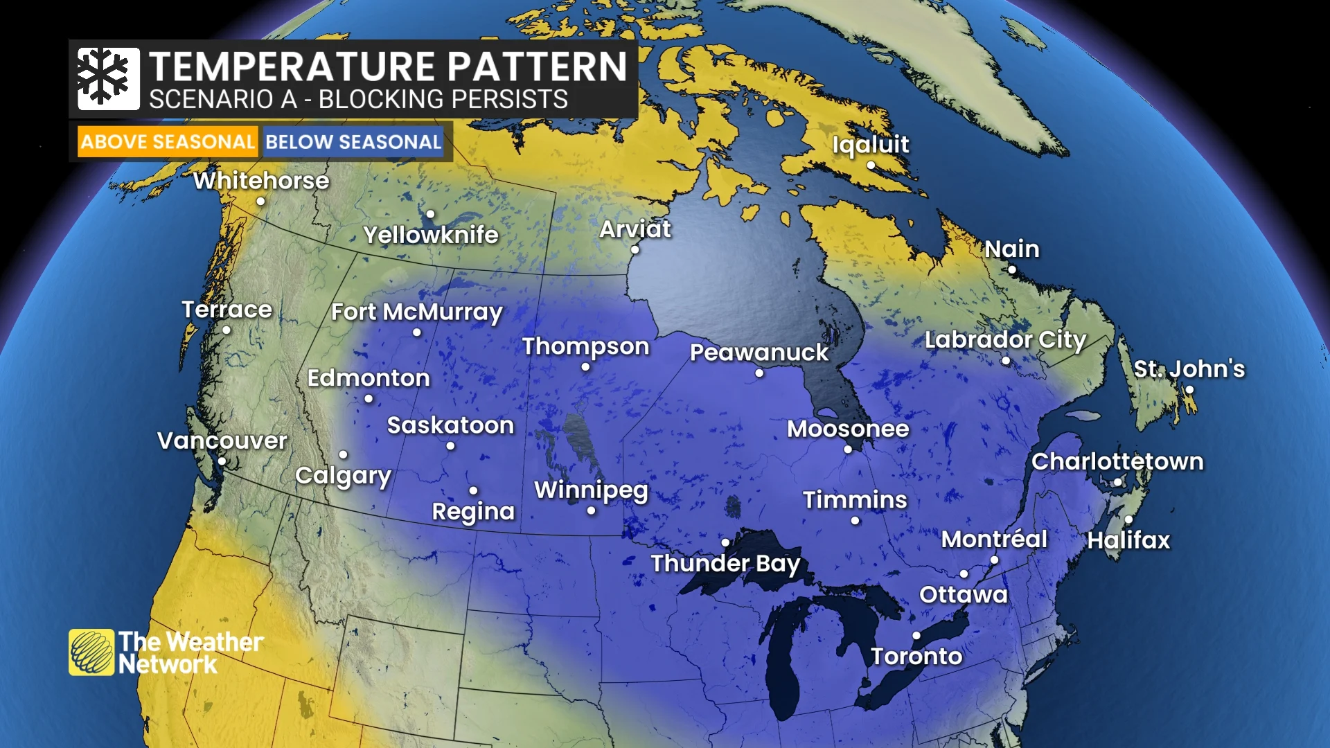
The temperature outlook if the blocking pattern persists (The Weather Network)
However, if the blocking pattern breaks down, the focus of winter’s fury would shift to western Canada (which is what we often see during La Niña winters).
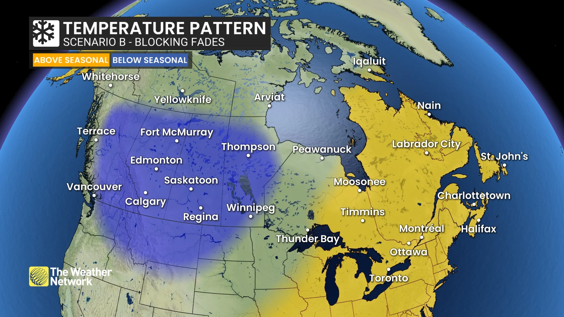
The temperature outlook if the blocking pattern fades (The Weather Network)
In this scenario (Scenario B), winter in eastern Canada won't be completely over, but it may become more unpredictable and variable, with the possibility of a longer period of milder temperatures.
Currently, the more widespread cold scenario (Scenario A) seems slightly more likely, but both patterns could occur during late January and February.
Regardless, most of Canada is forecast to see a more traditional Canadian winter with near-normal or colder-than-normal temperatures overall. Parts of Atlantic Canada and far northern areas have the best chance of seeing above-normal temperatures.
Here is our temperature outlook for December, January, and February overall:

Overall temperature outlook for winter 2025-26 (The Weather Network)
Precipitation and snowfall outlook
An active storm track should deliver near-normal or above-normal precipitation and snow totals to most of Canada.

Precipitation outlook for winter 2025-26 (The Weather Network)
However, Nova Scotia and eastern Newfoundland could see less than their typical amount of snow due to several messy storms that bring a mix of precipitation types, including rain at times.

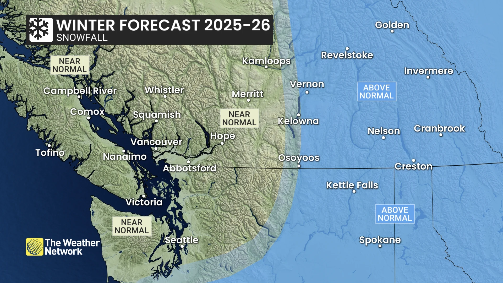
Snowfall outlook (The Weather Network)
Provincial and territorial breakdown
Below is a more detailed look at what we can expect across Canada during the upcoming winter season.
British Columbia
A cold winter is expected across the eastern half of the province with a heightened risk for periods of severe cold. Coastal areas, including Vancouver and Victoria, should be close to normal, but there is still a risk for Arctic outflow events.

An inconsistent storm track into the B.C. coast is anticipated, with stretches of dry weather interspersed with active periods that deliver moisture-laden storms. The stormy stretches should make up for the dry spells and bring precipitation and snow totals close to normal for most of the province.
However, the north coast is expected to be drier than normal, while above-normal snowfall is forecast for the Kootenays and Rockies. The risk for Pineapple Express events, which are notorious for bringing heavy rain to the alpine regions, is lower than normal.
WATCH BELOW: A closer look at the winter forecast for British Columbia
Alberta
A very cold winter is expected across the province. The frigid pattern will relax at times, and Chinook winds will bring temporary relief, but colder-than-normal temperatures are expected to dominate the season.
Above normal snowfall is expected across southern Alberta, including Calgary, while near normal snowfall is expected across central and northern parts of the province, including Edmonton. This includes the typical threat for blizzard conditions at times.
WATCH BELOW: A closer look at the winter forecast for Alberta, Saskatchewan and Manitoba
Saskatchewan and Manitoba
A frigid winter is expected across the region, including Saskatoon, Regina, and Winnipeg. While the pattern will relax at times, colder-than-normal temperatures are expected to dominate with a heightened risk for extended periods of severe cold.
Near-normal snowfall is expected across most of the region with the typical threat of blizzard conditions at times. Above-normal snow totals are forecast for southwestern Saskatchewan.
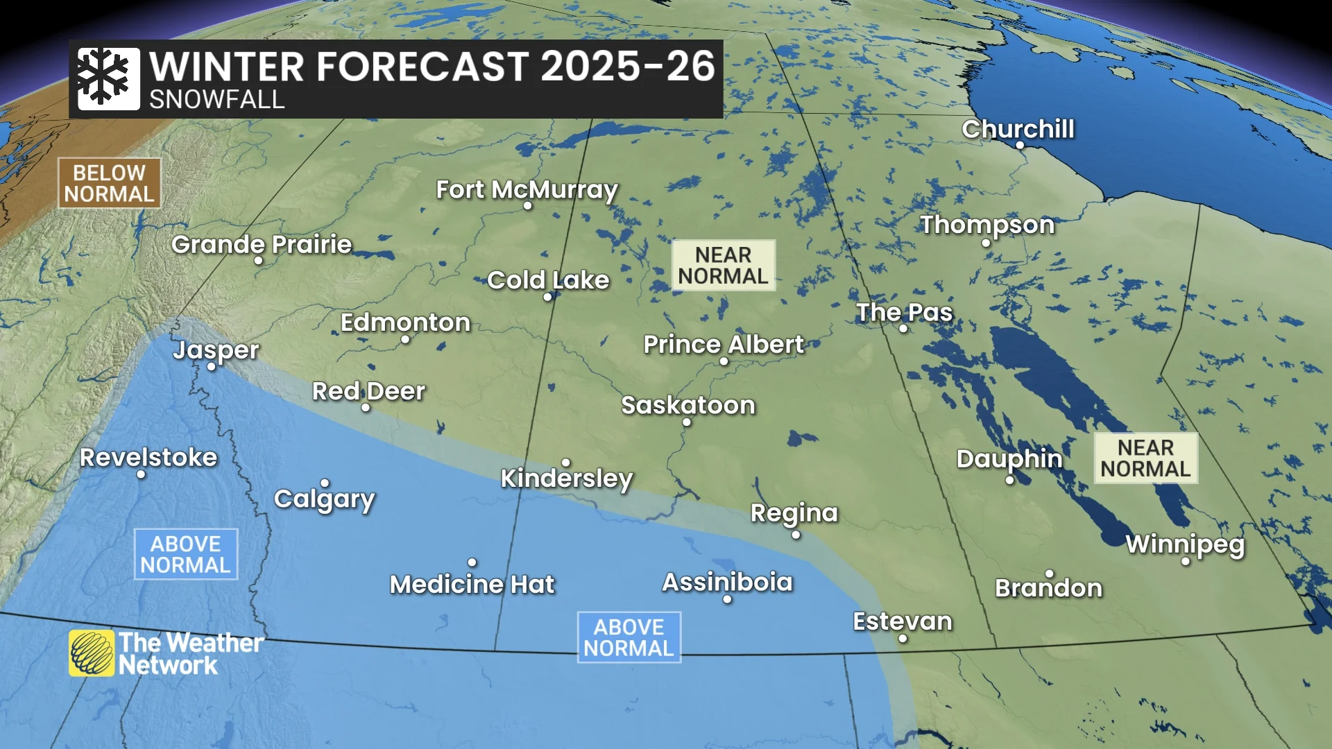
At this point, it appears that colder than normal temperatures will linger well into March across this region, with a delayed transition into spring.
Ontario
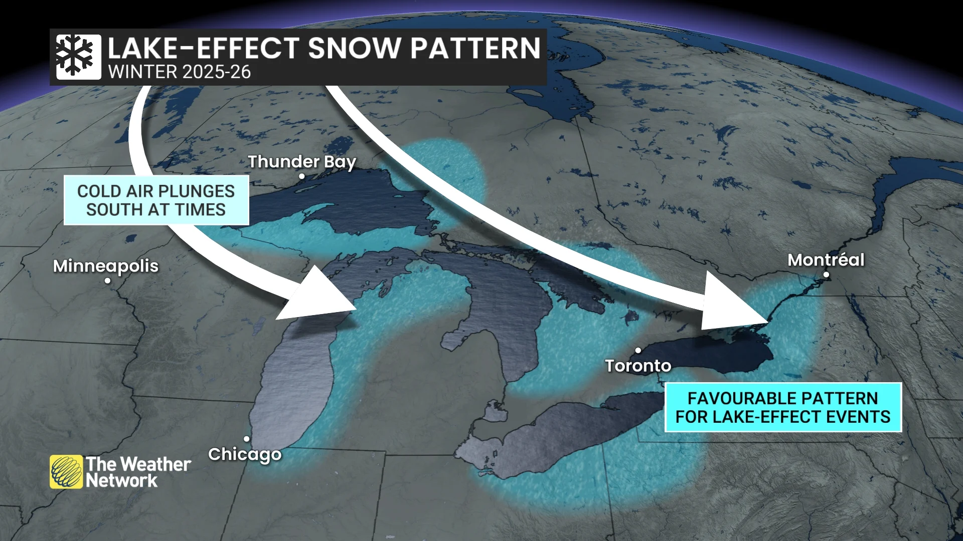
A cold start to the season is likely with more winter weather leading up to and through the holidays across southern Ontario than we have been accustomed to seeing in recent memory. This will include an abundance of lake-effect snow across the traditional snow belts, including ski country.
Colder than normal temperatures are expected well into January across the province. However, the pattern could become more changeable during the second half of winter, especially across southern Ontario from Windsor to Ottawa, with the potential for an extended stretch of milder weather.

An active storm track should bring near-normal or above-normal precipitation and snowfall to the region. However, southern areas, including London and Toronto, will see messy storms at times with a risk for ice and even rain, especially during the second half of the season.
WATCH BELOW: A closer look at the winter forecast for Ontario
Quebec
After an abrupt transition to early winter weather during November, the cold start to the season will continue through December with more wintry conditions leading up to and through the holidays than we have been accustomed to seeing in recent memory in the Montreal area.
Colder than normal temperatures are expected well into January, but the pattern could become more changeable during the second half of winter with the potential for an extended stretch of milder weather.
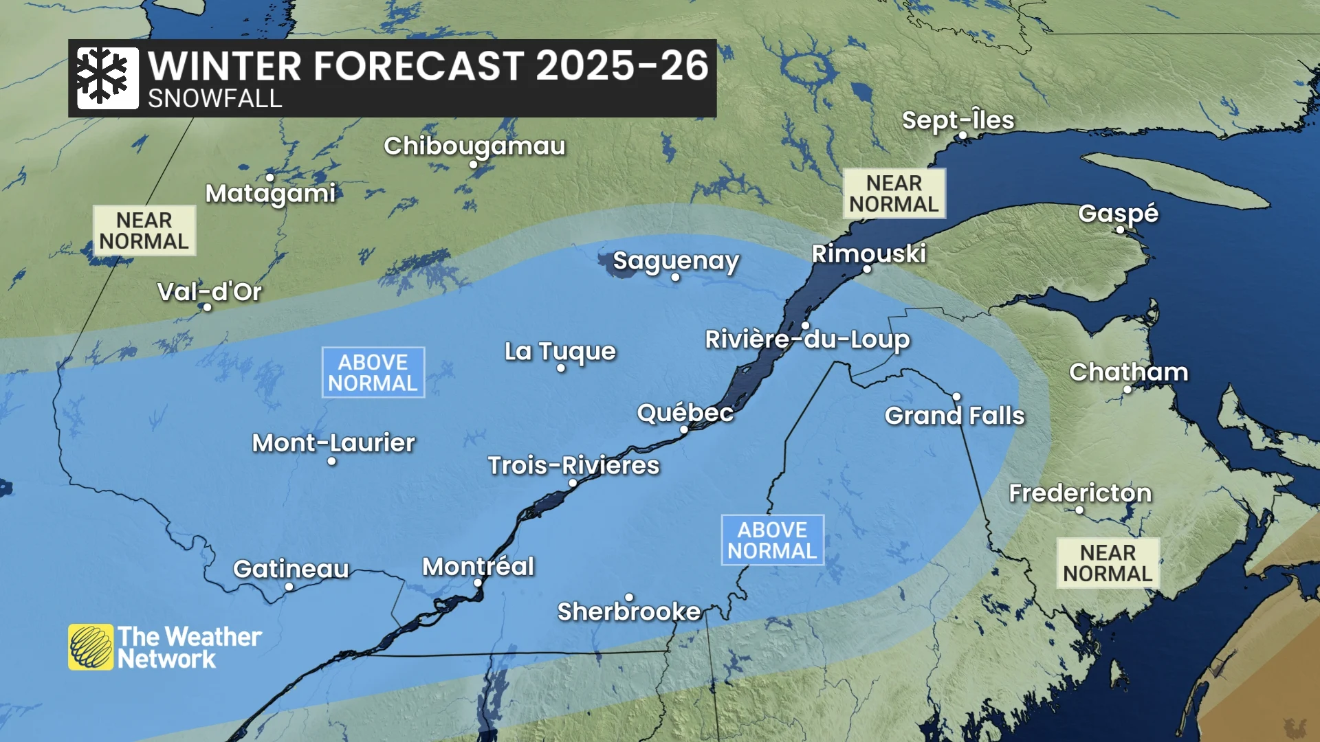
An active storm track should bring near-normal or above-normal precipitation and snowfall to the region, but southern areas could see a few messy storms with a risk for ice and even rain, especially during the second half of the season.
WATCH BELOW: A closer look at the winter forecast for Quebec
Nova Scotia, New Brunswick & Prince Edward Island:
A changeable winter is expected across the region with stretches of very cold weather, (especially leading up to and through the holidays) offset by periods of milder weather. Southern Nova Scotia, including Halifax, has the best chance of seeing above-normal temperatures overall, especially later in January and February.
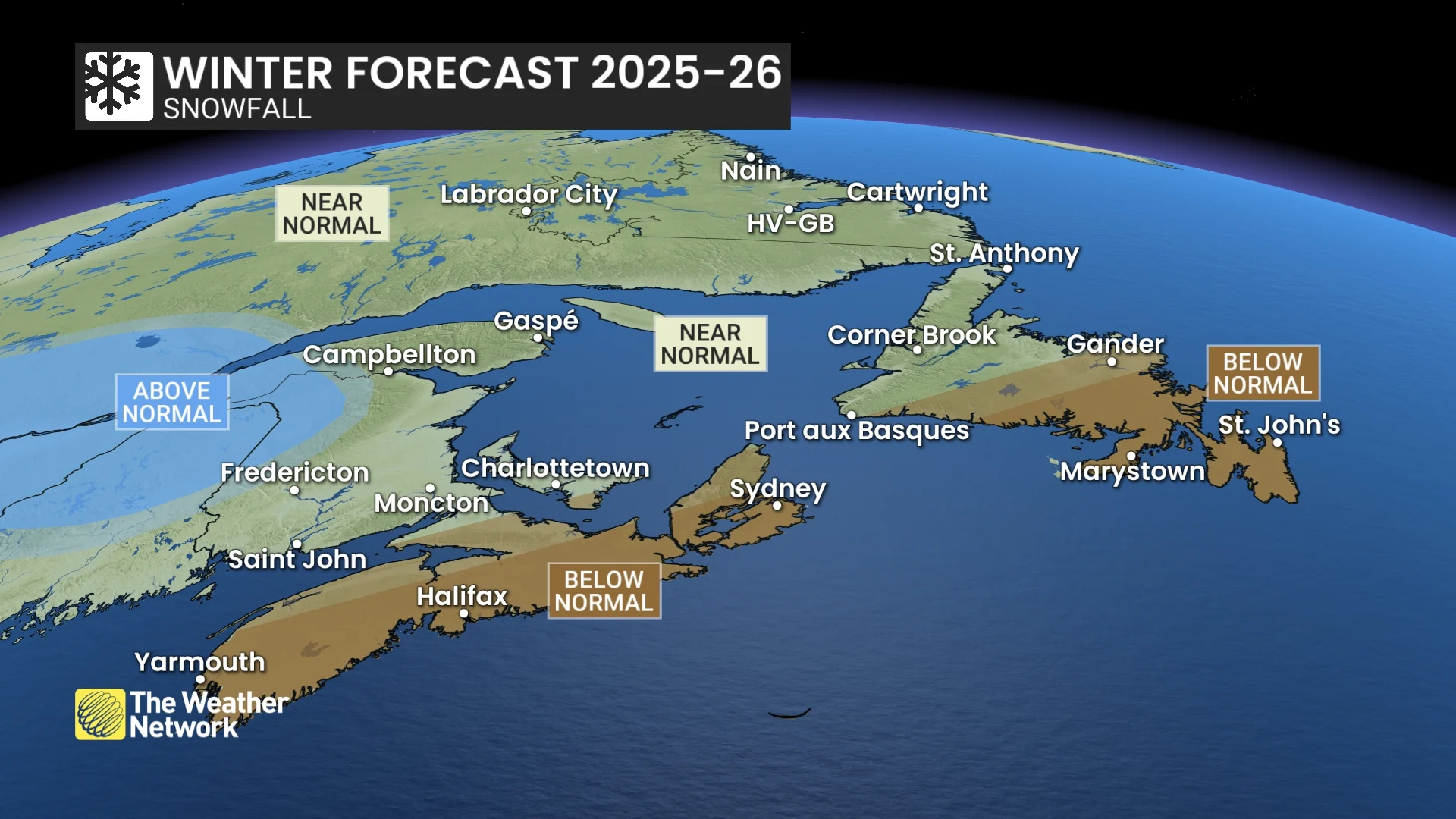
Near-normal precipitation is expected during a season that is known for being very active, and this will include a few high-impact winter storms, and a risk for blizzard conditions. However, below-normal snow totals are expected for Nova Scotia due to more messy storms that include ice and rain.
WATCH BELOW: A closer look at the winter forecast for Atlantic Canada
Newfoundland and Labrador:
A changeable winter is expected across the province, which will include stretches of very cold weather (especially during the first half of the season). However, periods of milder weather, (especially later in January and February) should more than offset the periods of cold weather, resulting in temperatures that are above normal for the season.
Near normal precipitation is expected during a season that is known for being very active, and this will include a few high impact winter storms and the risk for blizzard conditions. However, below normal snow totals are forecast across eastern Newfoundland, including St. John’s, due to more messy storms that will include ice and rain.
Northern Canada
Near-normal temperatures are expected across the Yukon, including Whitehorse, and the Northwest Territories, including Yellowknife. However, much of Nunavut, including Iqaluit, will see above-normal temperatures with less severe cold than we typically experience during winter.
Near-normal snowfall is expected for most of the region, but below-normal snow totals are expected for southern parts of the Yukon. A more changeable pattern is expected through the season with a risk for more windy days and ground blizzard conditions.