
Winter weather to make its messy debut in these major Ontario regions
The first impactful, snowy system of the season for the GTHA, Niagara, and Ottawa will move in on Wednesday morning. Commuters should consider avoiding travel if possible.
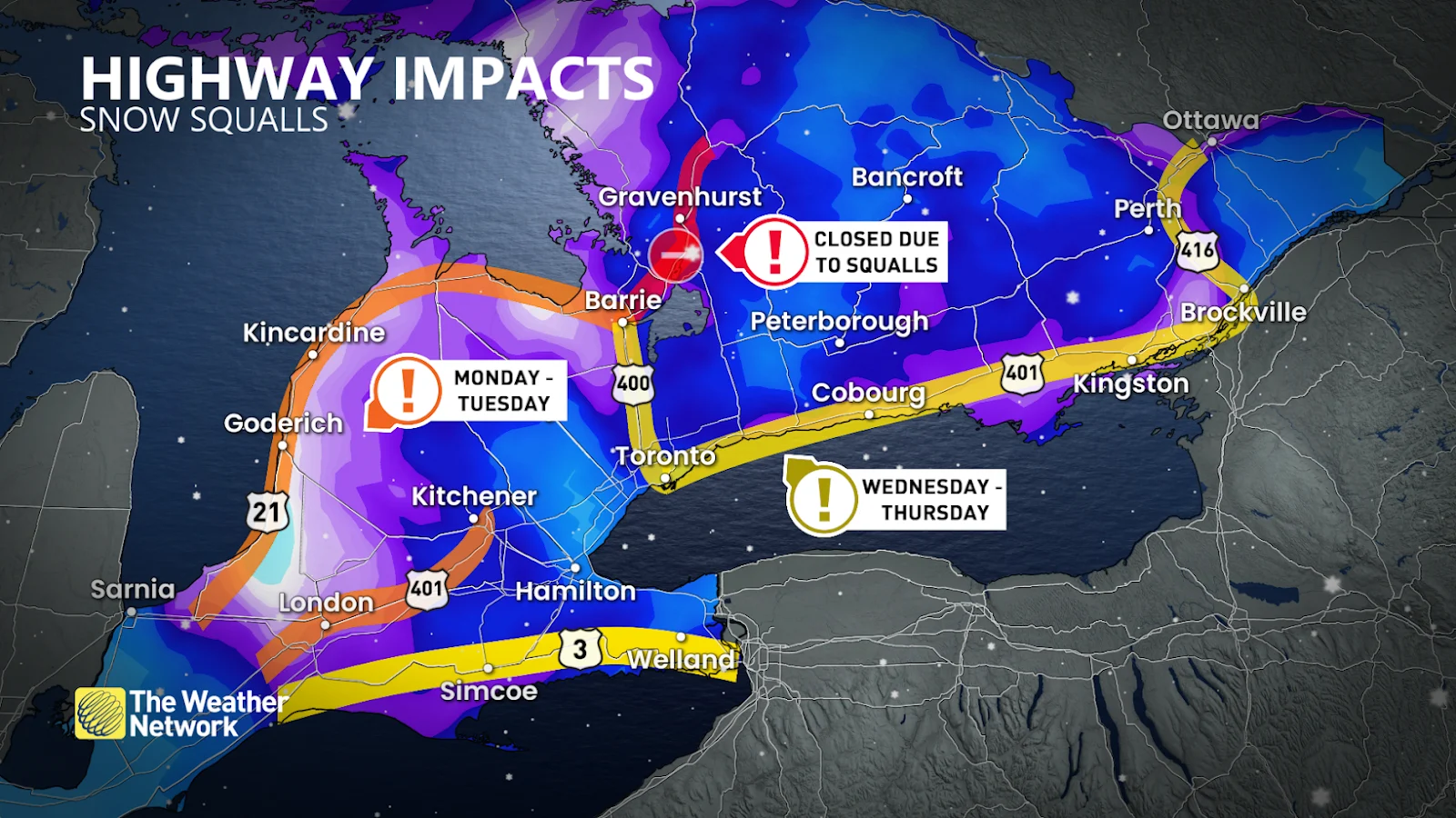
After a weekend of snowy weather to the north, it's finally southern Ontario's turn for some winter weather.
Lake-effect snow squalls brought up to 100 cm of snow to parts of Cottage Country and the snowbelts over the weekend, leaving major highways closed and municipalities, such as Gravenhurst, in a state of emergency.
PHOTOS: Unrelenting snow squalls blast Ontario with major totals, impact travel
Over 25,000 customers are without power throughout Cottage Country as of Monday morning.
Meanwhile, the weekend for the rest of southern and eastern Ontario was treated to only a little, if any, snow and chilly temperatures.
But, as we head into the final month of 2024, it's finally time for winter to make its way to the rest of the province.
The difference in air temperatures over the Great Lakes and over land will serve to enhance the snowfall as it moves inland off of the lakes on Wednesday. This will also result in bursts of heavy snow at times, making for a messy situation.
The snow will begin early Wednesday morning across southern and eastern Ontario, just in time to impact morning commutes. All major routes will be impacted by the snow, but commuters through Cottage Country and Niagara, as well as along Highway 401 east of Toronto, will be at an increased risk of significant snowfall accumulations and whiteout conditions. Folks in these specific areas should consider working from home and avoiding travel if possible.
SEE ALSO: La Niña’s sputtering role in an uncharted season ahead

Exact snowfall totals are uncertain at this point in time, but so far we're looking at 5-10+ cm around the Greater Toronto-Hamilton Area, Niagara, and Ottawa. The lake enhancement effect could bring localized totals up to 15+ cm, especially further north, around Cottage Country and Kingston.
To add to the slew of messy weather, winds will also pick up early Wednesday, gusting to 60-80+ km/h.
Blowing snow will be a major concern, especially around agricultural lands, as visibility may be reduced to near-zero.
Stay with The Weather Network for more forecast information and updates on your weather across Ontario.