Storm exits Newfoundland as possible nor'easter threatens Nova Scotia

As one storm winds down in Newfoundland Wednesday, another takes aim at Nova Scotia and parts of New Brunswick for Thursday, ushering in a healthy shot of snow for some.
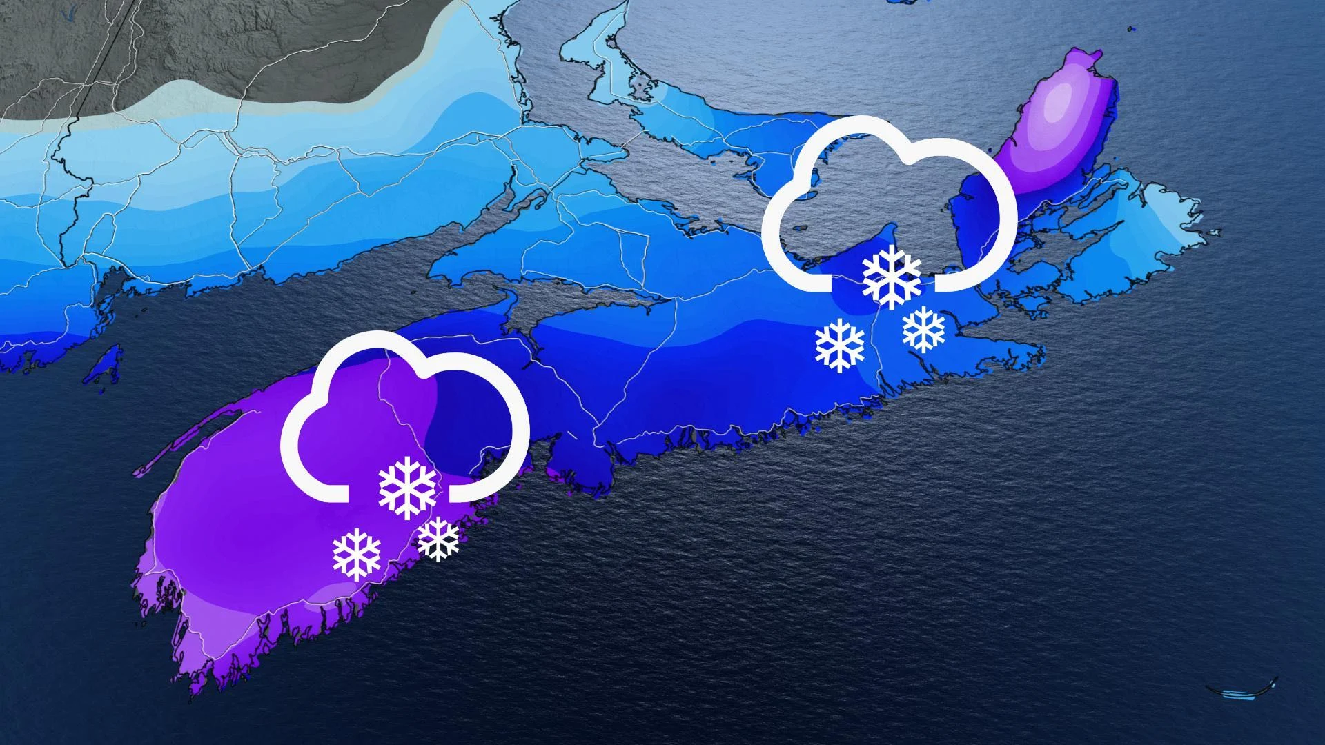
Newfoundland and eastern Nova Scotia will be reeling with lingering snowfall and blustery winds Wednesday, as a significant snowstorm, a potential nor'easter, follows on its heels for Thursday for parts of the Atlantic region. The strong low is on a northward trajectory along the U.S East Coast, and will bring heavy snow to southern Nova Scotia starting Wednesday night and continuing through Thursday. The track has shifted north somewhat, so heavier amounts are forecast for Yarmouth and Halifax. Even southern New Brunswick will see some of the snow, but far less than what is expected in Nova Scotia. Winds will also be quite strong, with 60-80 km/h gusts for coastal regions of the aforementioned province. More on what's ahead for Wednesday and Thursday, below.
WEATHER HIGHLIGHTS:
Snow continues Wednesday for parts of Newfoundland, Cape Breton Island
Strong winds of 100+ km/h along coastal Newfoundland will ease off Wednesday afternoon
Possible nor'easter pushes heavy snow into southern Nova Scotia Wednesday overnight, 15-25 cm in some areas through Thursday
WEDNESDAY: WINTER STORM WINDS DOWN IN NEWFOUNDLAND, NEXT STORM TARGETS MARITIMES
While conditions will improve during Wednesday for Newfoundland, there will continue to be sea-effect snow behind the low for Cape Breton and Newfoundland, resulting from a westerly flow. Snow will taper off in the evening hours for both regions.
The highest accumulations are expected over inland areas of Newfoundland. Temperatures will be around the freezing mark along the coast, which could cause some melting to occur, resulting in reduced accumulations. Snowfall warnings are still in place.
An additional 10-20 cm is expected in the extreme northern tip of the island and western coastal sections. Lesser amounts for the eastern areas.

Winds will continue to be blustery through the morning, with gusts exceeding 100 km/h along coastal areas of Newfoundland, creating more blowing snow and difficult travel. Winds will die down in the afternoon.
"Be prepared to adjust your driving with changing road conditions. Surfaces such as highways, roads, walkways and parking lots may become difficult to navigate due to accumulating snow," Environment Canada says in the snowfall warning.
Meanwhile, Cape Breton will see snowfall rates diminish through the day on Wednesday as the winds begin to ease. An additional 10 cm is possible.
The active weather doesn't end on Wednesday, however.
While there was some uncertainty regarding the snowstorm that is heading up the U.S. East Coast for impact on parts of Atlantic Canada, models have now indicated the potent low will head further north as it reaches the southern Maritimes.
The system will begin to bring snow into southern Nova Scotia in the overnight hours Wednesday.
THURSDAY: LATE-WEEK STORM TRACKS FURTHER NORTH, HEAVY SNOW FOR NOVA SCOTIA
Special weather statements are already in place for Nova Scotia as the potential nor'easter will have hefty snow and wind impacts for parts of the province through the day Thursday.
Because of the slight shift to the north, New Brunswick can also expect some snow as the northern edge of the storm creeps in, though far less than what is forecast for southern and eastern Nova Scotia.

"As with most storms that pass south of Nova Scotia, a small difference in the forecast track will could result in a significant change in the snowfall forecast," Environment Canada says in a special weather statement for Halifax.
As of now, 15-25 cm is expected for Yarmouth and nearby regions, with less amounts as you head east and north. 10-15 cm is possible for Halifax, but if the track moves further north again, heavier amounts are likely. Cape Breton Island is likely to see 15-20 cm.
Northeasterly winds will also be strong, intensifying in the afternoon and evening hours, with gusts of 60-80 km/h along coastal areas, and 50-70 km/h in the Bay of Fundy.
Conditions will begin to improve by Thursday night, as the fast-moving low continues to head east. Because of its track, the system will skirt south of Newfoundland with little to no impact whatsoever.
Be sure to check back for the latest updates on the active weather in your area.