Disruptive winter storm threatens East Coast with numerous, messy hazards
Folks on the East Coast should anticipate numerous disruptions through Monday as a messy winter storm will bring a buffet of precipitation and blustery wind gusts
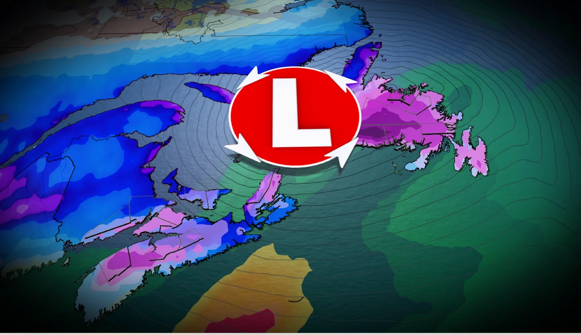
The next winter storm is targeting Atlantic Canada on Sunday, lasting into Monday, expected to hit the region with the entire spectrum of icy precipitation.
Some communities will see several different types of precipitation in rapid stages through the beginning of the week.
DON’T MISS: El Niño incoming? Forecasters see signs of big changes ahead
Please monitor subsequent forecasts and consider adjusting travel plans to avoid the most adverse conditions. Roads and walkways will likely become icy and slippery. Brace for some disruptions to transportation, services, and utilities.
A true wintry mix spreads over Atlantic Canada
Here’s a region-by-region breakdown of how the precipitation will unfold in your area on Sunday and into early Monday.

New Brunswick: Temperatures should allow the province to see mostly snow from this system, with a wintry mix expected near the Bay of Fundy through Sunday evening, with a risk of freezing rain. Heavy snow will develop for extreme eastern New Brunswick as low lifts north, bringing local, blowing snow. Totals of 10-15 cm are forecast from Moncton to Miramichi.
Nova Scotia: Warmer temperatures here will allow precipitation to begin as a wintry mix in central Nova Scotia before changing over to rain by the early-afternoon hours along the coast. The highest risk for freezing rain includes inland Nova Scotia, including the Annapolis Valley up toward Cape Breton. Rainfall totals are highest along the coast, with up to 30 mm in some cases. Bursts of wraparound snowfall are forecast through early Monday, accompanied by gusty winds as the temperatures fall.

Prince Edward Island: The island will find itself caught between milder air to the south and colder air to the northwest, which will likely promote a true wintry mix throughout the event. Expect precipitation to begin as snow that transitions to ice pellets or freezing rain, then over to rain for eastern portions of the island, before all changing back to snow early Monday.
Newfoundland: Periods of snow will quickly give way to a wintry mix across a large portion of the island by Sunday evening. The warm front will deliver 5-15+ mm of freezing rain to central Newfoundland before precipitation transitions back over to snow Monday afternoon.

The Avalon, Bonavista and Burin will see a switch to rain through the pre-dawn hours on Monday, with stubborn freezing rain ongoing in Gander. Western parts of the island can expect 10-30+ cm of snow, with less than 5 cm in the forecast for the Avalon.
Beware a risk for high winds into Monday
The wintry mix isn’t the only hazard that’ll accompany this system across Atlantic Canada.
A rapidly intensifying low-pressure system over the Gulf of St. Lawrence is a recipe for strong winds throughout the entire region.

Peak winds arrive on Monday afternoon, with strong and locally damaging, southwesterly wind gusts forecast all across eastern Newfoundland.
Widespread wind gusts of 60-80+ km/h are in the forecast. P.E.I. could see gusts as high as 100 km/h, with gusts up to 120 km/h possible on Cape Breton. The southern shores of Newfoundland may see gusts as strong as 130 km/h on Monday.