Most of Vernon, B.C., on evacuation alert due to White Rock Lake wildfire
The White Rock Lake fire burning between Kamloops and Vernon, B.C., has prompted an evacuation alert for most of the city of Vernon, which has a population of around 40,000.
This means residents must be ready to leave their homes at a moment's notice.
The city tweeted the decision was based on advice from B.C. Wildfires.
"The decision was made out of an abundance of caution based on the advice of BC Wildfire due to increased fire activity & increased ember debris," it said.

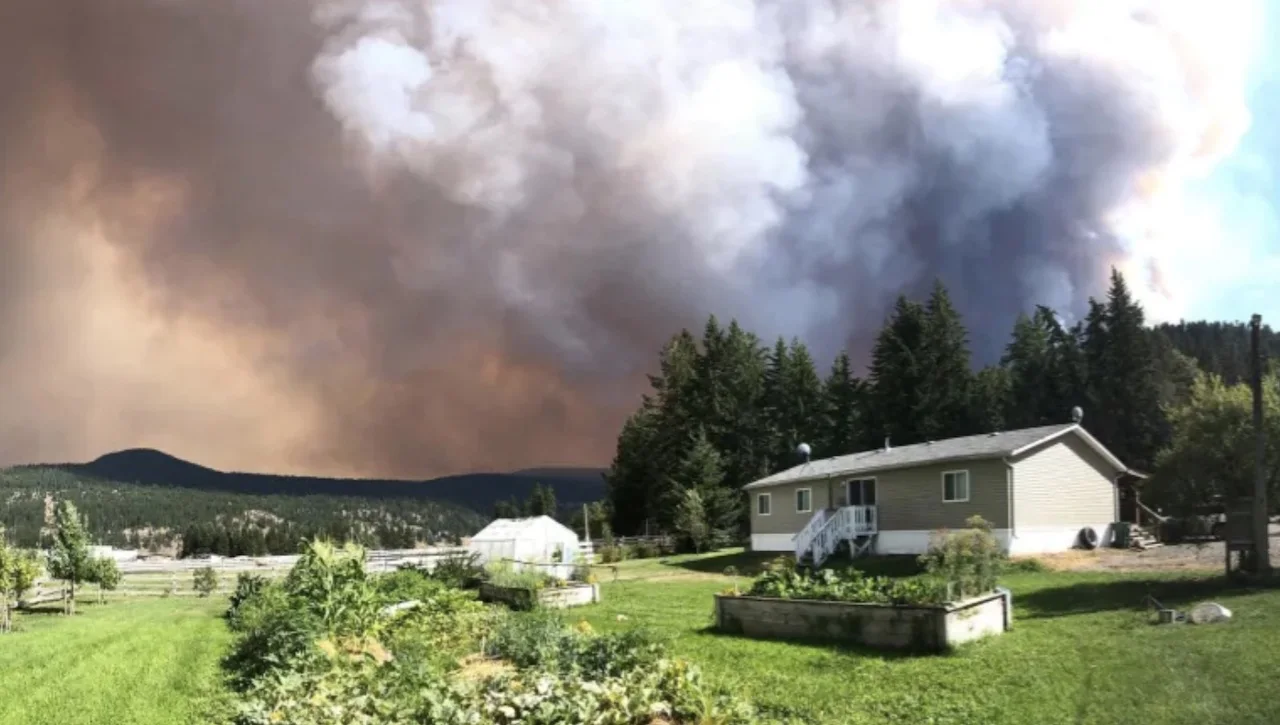
The White Rock Lake fire is pictured on Thursday, Aug.5. The fire has since grown. Its last estimated size was 550 square kilometres. (Bernie Hudyma)
The entire city of Vernon is on an evacuation alert excluding:
The Predator Ridge neighbourhood/ Sparkling Hills resort.
Okanagan Landing south neighbourhoods.
Commonage area south of Bench Row Road.
Late Friday night, new evacuation alerts were announced for Electoral Area B, east of Okanagan Lake, Electoral Area C, west of Forsberg Road, and the District of Coldstream from the north boundary to the south boundary in the area west of Grey Road. These properties are all east of the city of Vernon.
SEE ALSO: A drop of rain ends Vancouver's 45-day drought
ARMSTRONG, SPALLUMCHEEN ALSO UNDER ALERT
Meanwhile, nearly 10,000 residents in the city of Armstrong and the township of Spallumcheen are also on evacuation alert. And at 11 p.m. PT, another alert was issued by Regional District North Okanagan.

The Central Okanagan Regional District issued an evacuation order for almost 1,000 properties along Westside Road late Friday evening, telling residents to leave immediately. The properties had previously been on evacuation alert.
Also, the Okanagan Indian Band has issued an evacuation order for properties on the east side of Okanagan Lake. There was already an evacuation order for properties on the west side of the lake.

Aggressive fire behaviour and southwesterly winds, gusting upwards of 40 kilometres an hour, are challenging suppression efforts on the White Rock Lake wildfire, says the B.C. Wildfire Service. (B.C. Wildfire Service)
Bruce Smith, an information officer with the emergency operations centre in Central Okanagan, said gusty winds prompted the order.
"They were on alert and were advised to be prepared to leave with little or short notice," Smith said. "Unfortunately tonight the conditions changed, and we had to put the area into an evacuation order."
As of Friday night, the White Rock Lake wildfire was an estimated 550 square kilometres in size.
B.C. Public Safety Minister Mike Farnworth said earlier Friday that the fire west of Okanagan Lake was the province's highest priority. It ripped through the community of Monte Lake overnight, destroying many properties.
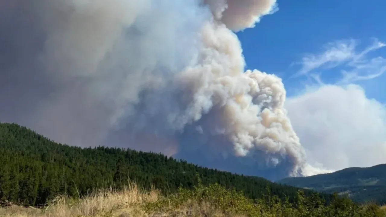
Monte Lake resident Stephanie Gamache took this picture of the White Rock Lake fire on Thursday. The fire is one of the largest of the close to 300 fires burning across B.C. (Submitted by Steph Gamache)
An update from B.C. Wildfire Service on Friday evening said southwesterly winds, gusting up to 40 kilometres an hour were challenging suppression efforts. The service said the fire was growing along its eastern perimeter.
Before the most recent directives, evacuation orders had already been in place for:
Over 600 properties in the Westwold, Monte Lake, Falkland and Cedar Hill areas.
373 properties in the vicinity of Pritchard.
544 properties under the jurisdiction of the Central Okanagan Regional District, including all properties in Westshore Estates.
608 properties from the south of Westshore Estates along Westside Road from Killiney Beach, including Ewings Landing.
Properties in the Six Mile-Nashwito area and Newport area for the Okanagan Indian Band.
Evacuation alerts — in which residents must be ready to leave at a moment's notice — had been issued for:
2,500 properties in Kamloops' Campbell Creek, Barnhartvale and Dallas neighbourhoods, southeast of the city's downtown core.
117 properties near Highway 1 and the Kamloops city limits.
1,400 properties in the Central Okanagan Regional District, residents living in Westside Road communities and subdivisions south of La Casa Lakeside Resort to north of Traders Cove (intersection of Bear Lake Main Forest Service Road and Westside Road).
The village of Chase and 83 homes southwest of the village under the jurisdiction of the Thompson-Nicola Regional District.
The Canadian Lake View Estates, Adventure Bay, Tronson Road, Rise, Turtle Mountain and Blue Jay communities in Vernon.
BE PREPARED FOR A WILDFIRE EVACUATION WITH A 'GRAB-AND-GO' BAG, HERE'S WHAT TO PACK
Anyone placed under an evacuation order should leave the area immediately.
Evacuation centres have been set up throughout the province to assist anyone evacuating from a community under threat from a wildfire. To find the centre closest to you, visit the Emergency Management B.C. website.
Evacuees are encouraged to register with Emergency Support Services online, whether or not they access services at an evacuation centre.
This story was originally published by CBC News. Contains files from Rachel Adams.