How this weird storm may be 2019's next hurricane
While their focus is usually over the oceans, for the past few days hurricane forecasters have been turning their gaze inland. An area of low pressure that's been brewing over the U.S. South is now emerging into Gulf of Mexico and, as it does, the second tropical system of 2019's Atlantic hurricane season is likely to be the result.
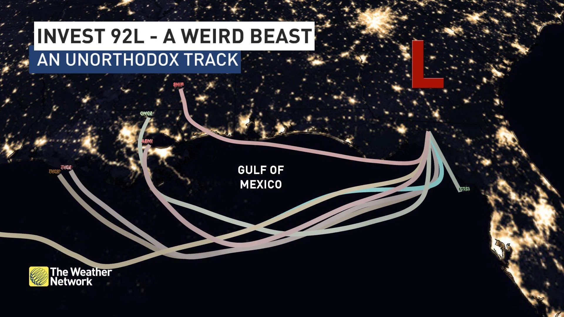
If you think it's odd that a tropical system would originate over the southern U.S., you're not wrong. While so-called 'homegrown' storms aren't out of the ordinary, particularly in the early part of hurricane season, they typically start in the southern Gulf of Mexico and move north. This curious system is set to do the exact opposite.
WATCH BELOW: THE WEIRD TRACK OF A WOULD-BE TROPICAL STORM
This potential system isn't just strange because of its origin; it's also headed the wrong way, at least when it comes to the typical track for tropical traffic.
WHAT'S DRIVING THE LOW?
There are a few key players in the development of this potential tropical feature -- currently dubbed 'Invest 92L' (short for 'investigation area') by the U.S. National Hurricane Center (NHC).
The biggest factors in the eventual track of the system -- whatever it becomes -- are areas of high pressure stationed over the southern Plains and off the Atlantic coast. Together, these highs are directing traffic over much of the southern U.S. as they form a ridge of high pressure stretching from Texas to Bermuda.

The ridge will block the low from moving north in the short term, and the clockwise flow around the stronger of the two pressure centres -- the one closer to the Rockies -- is expected to steer the low out into the Gulf before ushering it back to the west.
The Bermuda-based high pressure centre gives winds more of a northerly push over the northern Gulf, but it remains to be seen how much impact it will have on our developing target. Weather models are divided on this, with some letting the low drift further offshore and some keeping it closer to land.
The third player is a trough of low pressure much closer to home, forecast to cut through the Great Lakes region through Thursday. The flow with this feature would work against the westward movement of the low, tending to slow it down over the northern Gulf, or perhaps shift it back toward the Florida Peninsula. But, as the map above makes clear, that trough is pretty far away from Invest 92L and isn't likely to have too much of an influence on the ultimate path.
RELATED: How Saharan dust has been putting a lid on hurricane season
WILL THIS DEVELOP INTO A TROPICAL STORM? HURRICANE?
So, assuming this low does make it out into the Gulf of Mexico -- and signs are good that it will -- what will become of it then?
The NHC gives a high chance that the system will develop into at least a tropical depression (a tropical cyclone with winds no stronger than 61 km/h) by late Wednesday or Thursday. Depending on the track, and how long the depression remains over the Gulf, some weather models go on to develop a full-blow tropical storm from there. A few even hint that the storm, which would be named Barry, will be a weak hurricane before it makes landfall again.

Sea surface temperatures in the Gulf of Mexico as of July 8 2019. Image courtesy NOAA.
Water temperatures over the northern Gulf will play a role here. In order to support a tropical storm or hurricane, sea surface temperatures need to be about 27ºC. Right along the coast south of Louisiana, water temperatures are currently approaching 32ºC -- more than ample fuel for a healthy storm.
Those warm waters will also make for a very juicy system, whether it develops into a tropical storm or not, and that means some very heavy rain is in store for the Gulf Coast.

SEE ALSO: New Orleans' levees are sinking
The system's motion -- skimming right along the coast -- also raises concerns for storm surge for parts of the Gulf Coast, particularly in vulnerable locations like New Orleans.
While this kind of track is quite rare, it's not entirely unheard of. 2008's Tropical Storm Edouard took a similar path, forming over the northern Gulf before cruising into the northeast coast of Texas in early August. While that storm relatively weak, it was still responsible for six deaths along the coast, five of them victims who drowned in rip currents along the Florida and Alabama coasts.


