Implications for eastern Ontario, Quebec travel from wintry wallop
A bout of heavy and wet snow will be poorly timed in eastern Ontario and Quebec on Thursday, falling during rush-hour traffic in urban areas. Brace for slower commutes
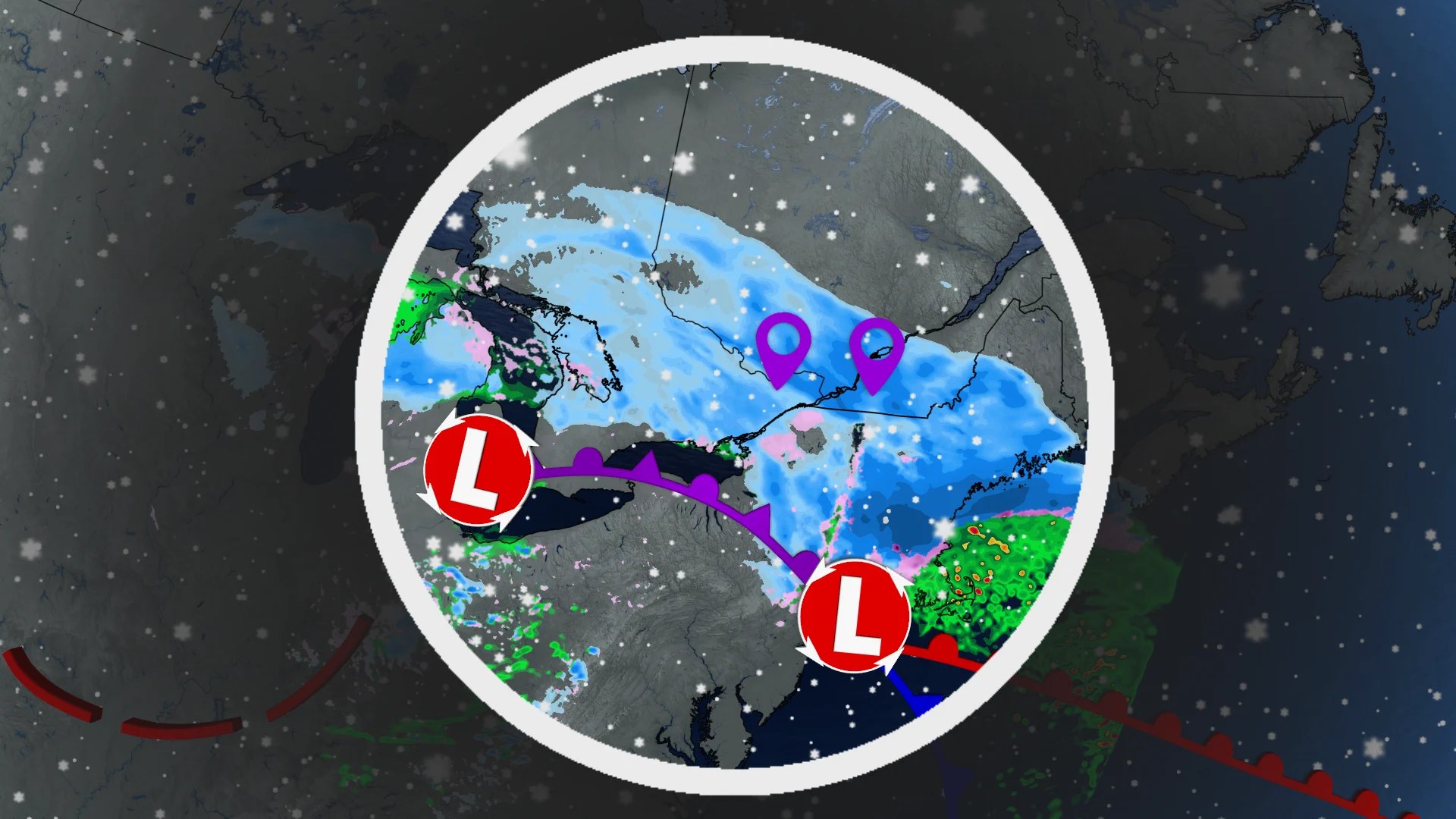
April is off to a messy start in Ontario and Quebec, thanks to multiple systems trekking through with rain, strong winds and snow.
Eastern Ontario and Quebec will be hit particularly hard by the snow into Thursday.
DON'T MISS: Canada faces a fickle April as winter wanes and summer teases
During its peak, the snow could be falling at a rate of 3 to 6 cm per hour, so visibility will be rather poor on the roads. Prepare for a much slower commutes during Thursday morning and evening, if you need to be travelling then.
Some locales in eastern Ontario and Quebec could see upwards of 10-25 cm of snow by the time it is over, with the potential for the system to overachieve in some spots.
Also be prepared for power outages as the heavy, wet nature of the snow could cause trees to topple or fall on power lines from the weight.
Thursday: Heavy spring snow threatens difficult travel
As temperatures cool further through the Wednesday overnight hours, precipitation will switch to wet snow. That's as a secondary low develops in the U.S. Northeast.

The snow is set to intensify into the afternoon hours on Thursday, and will be at its heaviest across eastern Ontario, including Ottawa and Bancroft, and into southern sections of Quebec, including Montreal, as well.
REALITY CHECK: Snowfall is normal in April for Canada. Here are the averages
Snowfall rates of 3-6 cm per hour are possible for a brief period through the overnight hours Wednesday and into early Thursday. Rapidly accumulating snow could make travel difficult in some areas, especially during the Thursday morning commute.

Winds will also be problematic, picking up early Thursday morning. Gusts of 50-70+ km/h will be reached, then easing by the evening. Power outages are possible due to the wet snow and strong winds.
Due to the dynamic setup of this system, there is still a bit of uncertainty in how much snow will fall. Temperatures will remain very close to the freezing mark for a good part of the system, greatly influencing the amount of snow that accumulates on the ground, as opposed to melting.
Between 10-20 cm of snow is currently forecast for Ottawa, with around 25 cm expected for Montreal. Even heavier totals are likely in Algonquin, the Laurentians, and parts of the Eastern Townships. There is the potential for some of these areas to overachieve with snowfall amounts.

DON'T MISS: Everything you need to know for April's spectacular and rare solar eclipse
Snow flurries will continue into Friday morning, though with a bump in temperatures bringing mixed precipitation and scattered rain.
A warming trend is forecast into the weekend, with temperatures climbing well above seasonal. Forecasters will continue to monitor conditions ahead of the total solar eclipse that’ll traverse the region on Monday, April 8.
Thumbnail courtesy of Dzung Tran, taken in Ottawa, Ont.
Check back frequently for the latest updates on the weather across eastern Ontario and Quebec.


