Up to 40 cm: Parts of the East Coast face snowy, windy wallop
A significant winter storm could bring 20-40 cm of snow to parts of Atlantic Canada, with travel and school interruptions likely
We're just in the early days of spring and Atlantic Canada is already looking at a significant winter storm to start this week.
The snow will come courtesy of two low-pressure systems that will blend together. Snow will push into the Maritimes on Sunday and Newfoundland on Monday.
DON'T MISS: Weather lore: Does 'borrowing days' indicate a stormy end to March?
Over the past 24 hours, confidence has increased for a major snowfall across the northern Avalon Peninsula and eastern Newfoundland.

Totals of 10-40 cm are expected across Atlantic Canada, with parts of Newfoundland seeing the heaviest amounts. Expect hazardous travel as winds and snow will make for reduced visibility and slippery roads. Travel delays and/or cancellations are possible.
Sunday afternoon: Snow pushes into the Maritimes
With the Halifax, N.S., area already reporting average amounts of snowfall for an entire March (33 cm), we’re guaranteed to see above-average snowfall as another low-pressure system embarks on a trek through Atlantic Canada.
Although the storms haven’t packed the same high totals as February delivered, those in Atlantic Canada know late March can still deliver harsh winter reminders.
Snowiest March days this year
March 4: 11 cm
March 14: 11 cm
March 13: 4.4 cm

On Sunday, a weak disturbance moves into the Atlantic from New England, spreading snow along the warm front across the southwestern Maritimes by the late afternoon.
By Sunday night, snowfall becomes steady across the South Shore of Nova Scotia. Winds along the coast pick up to 30-60 km/h, increasing the risk for reduced visibility and local, blowing snow conditions.
Monday and Tuesday: More disruptions likely as snow pushes east
On Monday, snow has the potential to mix with ice pellets along the southern tip of Nova Scotia. However, locales inland will remain as all snowfall.
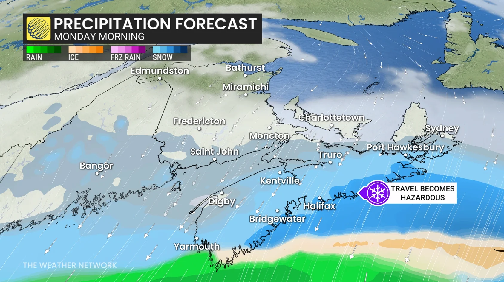
Heaviest snowfall rates develop along the entire coast of Nova Scotia, from Yarmouth to Sydney (1-3 cm an hour).
Snowfall lightens across the Halifax area, but remains locally heavy across southeastern Nova Scotia, including southern Cape Breton, where more bursts of heavy snow are forecast through Monday evening.
Very little snowfall accumulation is expected for New Brunswick and P.E.I. As much as 5-8 cm is possible for southwestern New Brunswick and 5 cm for P.E.I.
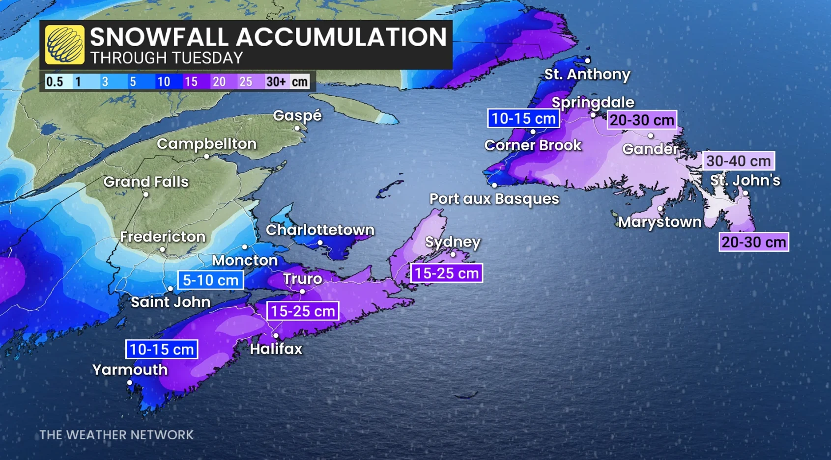
Heavier, widespread totals of 10-20 cm are forecast for most of Nova Scotia from Sunday afternoon to Monday afternoon, but up to 25 cm is possible locally in some areas that see lingering snowfall late Monday.
RELATED: Thundersnow is a rare and electrifying experience
Snowfall rates taper across the southern Maritimes, remaining locally heavy for Cape Breton later into Monday evening.
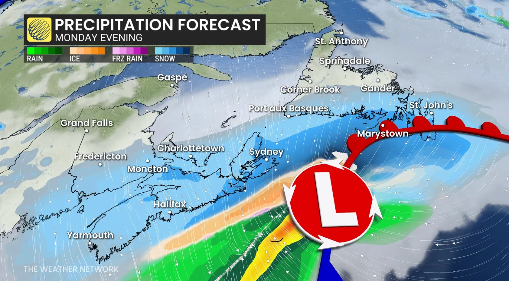
As the low passes northeast of Sable Island, the warm front lifts across Newfoundland on Monday night, providing some of the heaviest snowfall rates of the entire event.
Snowfall rates rapidly increase as the low passes east of Sable Island. rates of 3-5 cm an hour is likely, with the peak occurring through the pre-dawn hours on Tuesday.

Snow is likely turning to a wintry mix across the Avalon Peninsula and southern regions early Tuesday morning (6 a.m. to 9 a.m. local time).
__St. John’s has increased to 30-40 cm of snow in the forecast.
The low continues to deepen as it lifts northeast of Newfoundland on Tuesday afternoon, resulting in strong winds, so blowing and drifting snow will be a concern across parts of the province.

Most of the Avalon has the opportunity to transition over to brief showers in the warm sector, while a wintry mix and snow are ongoing across central and western regions.
The low lifts across the province, deepening to 980 hPa, sparking the threat for gusty winds. 70-90+ km/h gusts are possible through Tuesday, with the strongest winds along northern coastal sections of Newfoundland (locally, reaching 100+ km/h).
Beyond, there will be the chance of another high-impact and messy system late next week.