Hurricane Lee slows down amid mystery over its eventual, northward path

Residents across Atlantic Canada should closely monitor Hurricane Lee’s progress through the week
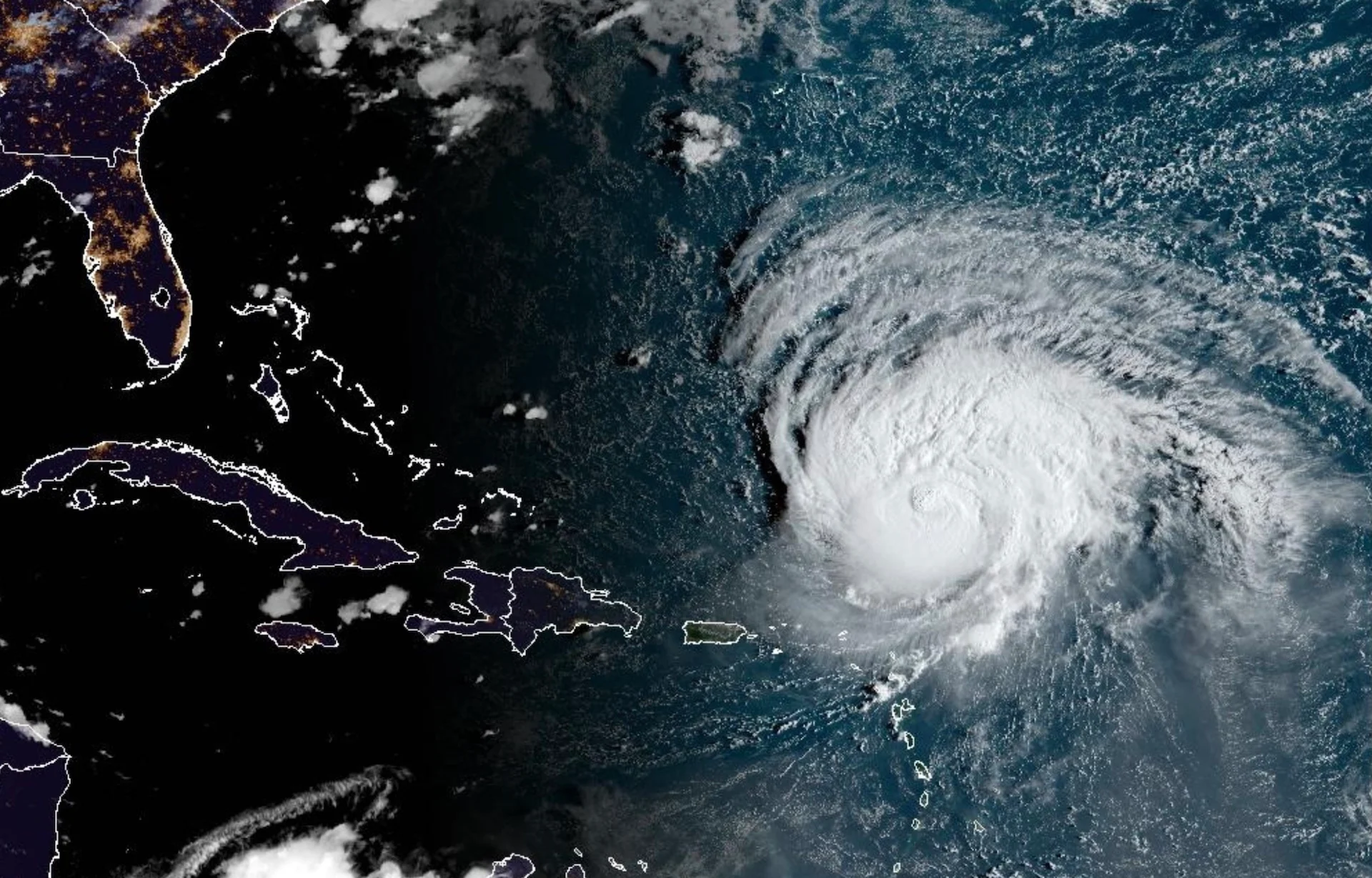
Hurricane Lee has slowed down in speed and intensity as it takes a path well away from the Leeward Islands Sunday, the beginning of its northward trajectory through the coming days.
The timing and location of this turn —- and the environment that’ll surround the storm as it migrates north -- will determine what, if any, impacts Hurricane Lee will have on Atlantic Canada or New England by the end of this week.
Visit The Weather Network's hurricane hub to keep up with the latest on tropical developments in Canada and around the world
Hurricanes are fragile structures, and it doesn’t take much to throw a storm’s inner core off balance. A bit of dry air and wind shear threw Lee for a loop on Friday, forcing the storm to weaken a bit from its scale-topping peak early in the morning on that day.
While the storm has weakened considerably since it reached Category 5 intensity on Friday, it’s still quite the force as it churns far north of the Antilles, and forecasters expect Hurricane Lee to regroup and become an extremely powerful storm once again Monday.

Data from a NOAA Hurricane Hunter aircraft indicate that the maximum, sustained winds have increased to near 175 km/h with higher gusts, just below Category 3 strength, according to a late-Sunday morning update from the U.S. National Hurricane Center(NHC). Some strengthening is forecast during the next couple of days.
Even though the storm is far from land, its ferocious winds have churned the ocean enough that rough surf and dangerous rip currents are expected on beaches across the Caribbean, Bermuda, and the U.S. East Coast in the days ahead.
DON'T MISS: A world first, every tropical ocean saw a Category 5 storm in 2023
WATCH: The best time to prepare for a hurricane is long before one threatens. Here's how
Uncertainty surrounds Lee’s northward turn and eventual path
It’s still too soon to predict how or if this hurricane will directly affect Atlantic Canada or New England over the next week.
MUST SEE: How a mammoth hurricane rapidly intensifies in mere hours
A complex wind pattern will emerge over the western Atlantic Ocean heading through this week, and small changes in this environment will have a large impact on where Hurricane Lee ultimately travels over the next seven days.
It’s important to note, though, that Hurricane Lee would not be at its peak strength if it affects land late next week.

A ridge of high pressure over the central Atlantic is currently steering Lee on its west-northwesterly track. This high will start to weaken and shift as we head into this week, allowing the storm to slow down considerably by the middle of the week as it passes north of the Greater Antilles.
Once this slowdown occurs, computer models generally agree that Lee will begin to turn north on Wednesday and Thursday as it feels the southerly winds of a trough dipping over the eastern United States.
The precise timing of this atmospheric tango will determine Lee’s track as we head through the latter half of this week into the weekend.
Individual factors like the strength of the ridges and troughs, as well as Lee’s own strength and position, will have a significant effect on the hurricane’s path. These factors are too delicate to predict with high certainty this far in advance.
Forecasters will have a clearer picture of the winds responsible for steering Hurricane Lee as we head through this weekend and into early next week.
Stay prepared
We’re now in the climatological peak of hurricane season across the Atlantic basin. Anyone along or near the East Coast should prepare for hazards like power outages and flooding regardless of this one storm’s progress.
Ensure you’ve got non-perishable food, water, personal hygiene supplies, flashlights, and batteries to last for several days without electricity or water. Prepare an emergency plan in case of flooding or evacuations.
STAY SAFE: What you need in your hurricane preparedness kit
Anxiety is normal when there’s a big storm out there, and even more so when the storm’s future is uncertain. Preparing for a storm now—long before one ever draws near—ensures you’ll be ready to go if anything looms on the horizon in the weeks and months ahead.
Stay with The Weather Network for the duration of this storm as we closely monitor this hurricane and its developments.
Header satellite image courtesy of NOAA.