
Ugly winter mess takes aim at Manitoba, NW Ontario, risk of 5-10 cm of snow, ice
Expect significant travel disruptions as a power Colorado low brings a messy mix of snow, winds, and icy weather to Manitoba and northwestern Ontario heading into the weekend
An ugly mess of weather is on the way for portions of Manitoba and northern Ontario as we head into the weekend — all thanks to a powerful Colorado low lifting northwards.
A widespread swath of heavy snow, freezing rain, rain and windy conditions are expected for southern Manitoba and northwestern Ontario through Saturday as the system tracks to Hudson Bay. Gusty winds exceeding 70 km/h are possible, as well, and when paired with wintry precipitation, travel disruptions are likely.
Visit our Complete Guide to Spring 2025 for an in-depth look at the Spring Forecast, tips to plan for it and much more!
A band of 5-10+ cm of snowfall is forecast, but the exact location is still uncertain at this time due to the ultimate track of the storm. Regardless of where it ends up, travel will be impacted by the wintry mess, so be sure to plan ahead.
Friday night through Saturday: Band of heavy snow and ice sets up across Manitoba and Ontario
A large Colorado low will track northward into southern Manitoba and northwestern Ontario, with messy weather expected to start as early as Friday evening.
A clash of warm and cold air is expected, bringing a cocktail of precipitation to both regions.

A band of heavy snow between 5-10+ cm is forecast, but the exact location is still uncertain at this time, as the transition from mixed precipitation to snow is difficult to nail down, with a few hours drastically changing the forecast.
Whoever sees this persistent snowfall will have higher travel impacts.

A wintry mix will divide the heavy snow and rainfall.
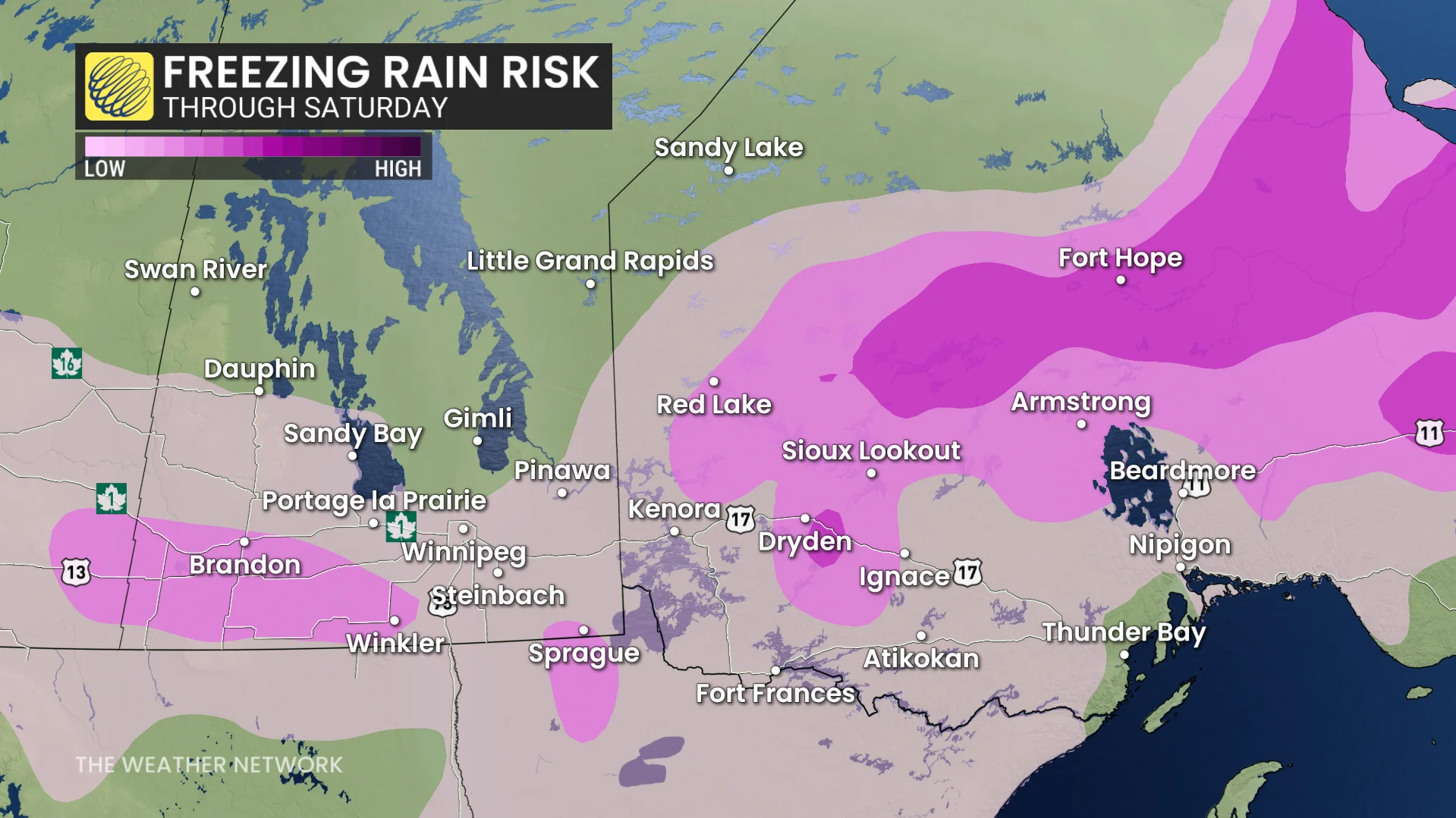
Beware of slick conditions with freezing rain threat on Saturday
There will be a risk of a period of freezing rain from southern Manitoba through to northern Ontario, with slippery conditions expected if it persists for several hours.

DON'T MISS: 130 million Americans may see 'biggest' severe weather event of 2025 so far
Meanwhile, rainfall is expected for Thunder Bay, while a wintry mix is expected for Kenora and regions northwest of the storm track. With the rain that is forecast in northwestern Ontario, embedded thunderstorms are also possible on Friday.
Powerful winds peak Saturday afternoon
Gusty winds will be a factor through the event, potentially exceeding 70 km/h, making travel quite difficult throughout the storm. The winds will become stronger Friday overnight and peak on Saturday afternoon.

Conditions will rapidly improve early Sunday as the low lifts towards Hudson Bay.
The uncertainty is very high for precipitation timing and type, and also the transition between precipitation types, as these details are dependent on nailing down an exact storm track. Confidence remains low on snowfall amounts projected across southern Manitoba, so be sure to continue to check back for updates.
Stay with The Weather Network for your latest forecast across Manitoba and northwestern Ontario.