
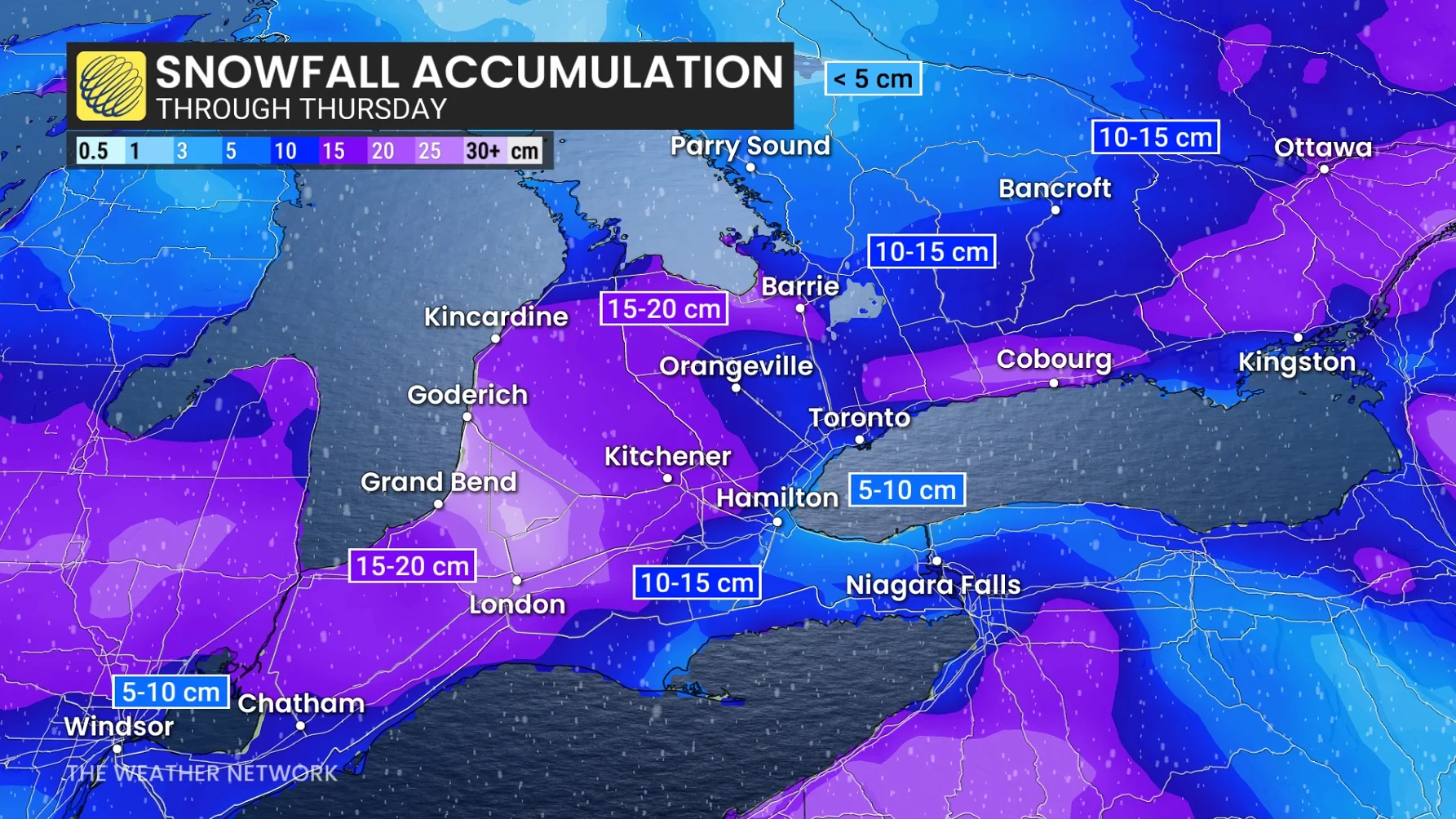
Two systems will spread another 5-15+ cm of snow across Ontario mid-week
Two clipper systems will bring 5-15+ cm of snow across parts of Ontario mid-week, with some lake-effect snow filling in behind
Wintry conditions persist in Ontario this December, with frigid temperatures, and several rounds of snow in the forecast this week. Some areas could receive another 5-15+ cm of snow ahead of winter's official start.
RELATED: Toronto braces for coldest temperatures in nine months
Light snowfall is expected Tuesday from the first system, with heavier snow set to develop overnight into Wednesday with the second system. Behind these pair of clipper systems will be another round of lake-effect snow targeting communities southeast of Lake Huron and Georgian Bay lat week.
Be sure to monitor the forecast for updates regarding snowfall amounts and impacts, as well as any alerts as conditions change or deteriorate.
Two clipper systems to bring another healthy swath of snow into Wednesday
The week began with a midwinter-like chill, bringing the coldest daytime highs in more than nine months to places like Toronto and Ottawa. Temperatures remain well below seasonal for most areas.
A clipper from the Prairies will bring a quick burst of snow Tuesday across central and southern Ontario. A general 2-5 cm is expected throughout the day, with blustery winds causing some blowing snow into the evening.
A second clipper arrives Tuesday night, carrying Pacific moisture, which will increase snowfall amounts and introduce slightly milder air.

Widespread snow will persist through Wednesday morning. As temperatures rise above the freezing mark, snow may transition to a wintry mix or rain for areas near Lake Erie and Lake Ontario.
RELATED: Toronto increases parking fines as snow hits the city
Snowfall totals of 5-15 cm are forecast with this system.
Lake-effect snow picks up late week, risk of an additional 10 cm
Lake-effect snow will develop behind the passing clipper, impacting areas southeast of Lake Huron and Georgian Bay. Regions near London and Barrie could see an additional 10 cm of snow on Thursday due to lake-effect activity.

Another system is being monitored for the weekend, which may bring widespread, accumulating snowfall across the region.
DON'T MISS: Canada’s December outlook holds a strong, cold start to winter
Staying cold through the holidays
Below-normal temperatures are projected to persist next week, potentially lasting through the holidays, accompanied by additional rounds of lake-effect snow. No significant pattern shift is expected.
Any mild conditions will likely be brief and linked to low pressure systems passing north of the area.
Stay safe out there as hypothermia can be a real risk this time of year.