
Severe storms, heavy snow likely this weekend in Western Canada

Heavy snow, drenching rains, and a risk for rotating storms will make for a strange and hazardous weekend across Western Canada
Summer is on hiatus across Western Canada this weekend as an unusually strong upper-level low plasters the region with a whole spectrum of hazardous weather.
The most pressing risk is the potential for severe thunderstorms in Alberta on Saturday. Some of those storms could rotate, so keep a close eye on watches and warnings through the afternoon and evening hours.
DON’T MISS: An odd Father’s Day weekend promises unusual snows and high heat
We’re also monitoring the potential for excessive rainfall in central and northern Alberta, with plentiful mountain snows across the Rockies and the South Coast. The return of wintry weather could interfere with any mountain outings planned over the Father’s Day weekend.
Saturday
Areas: Southern Alberta and Saskatchewan
Timing: Through the afternoon and evening hours
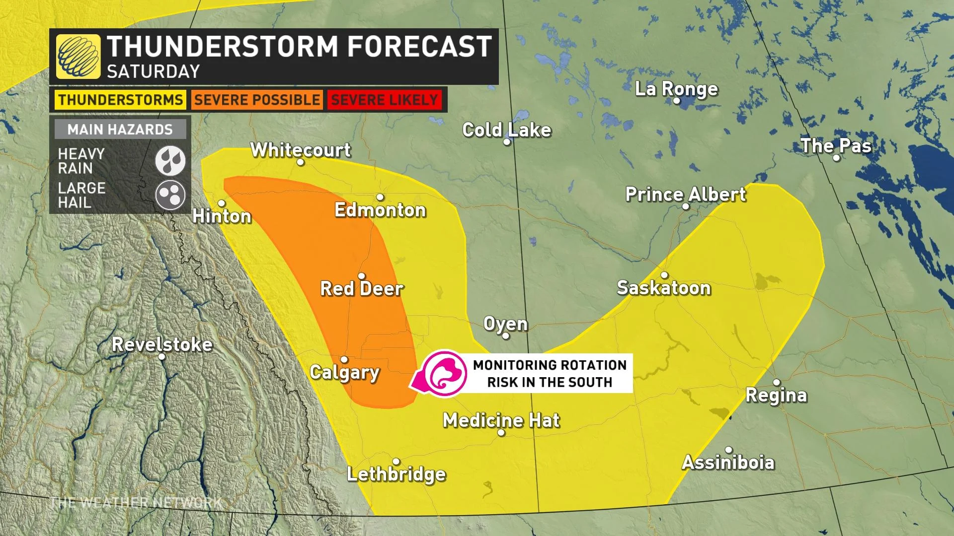
Weather: Saturday will see a tricky thunderstorm setup spanning portions of Alberta, following the foothills from the Calgary metro area north through Red Deer toward Hinton.
Weak instability and some daytime heating will spark a threat for scattered thunderstorms south of Red Deer during the afternoon hours. A low-pressure system pushing into the region will provide both the kick and the wind shear needed to potentially help some of those storms reach severe limits. Heavy rain and large hail are the main threats.

Forecasters are closely watching the potential for rotating thunderstorms in southern Alberta. It’s important to keep up with watches and warnings throughout the day Saturday, and ensure you’ve got safe shelter nearby if severe storms approach your location.
Confidence: Given the tricky setup involved, there’s low confidence in the potential for rotating thunderstorms. The risk exists, though, so be sure to check back for the latest updates, and have a safety plan if this weekend takes you outdoors.
SEE ALSO: Don’t fall victim to these seven dangerous tornado myths
Summer snow this weekend, excessive rains through next week
The upper-level low swinging into the West Coast this weekend is unusually potent for this time of year, which will make conditions feel positively spring-like over the next week.

Colder temperatures accompanying this system will send freezing levels quite low, allowing a healthy coat of snow to blanket elevations above 2000 m in the Rockies, with snow above 1800 m a possibility along B.C.’s South Coast. Snowy conditions and chilly temperatures may pose a challenge for folks heading into the mountains this weekend.

DON'T MISS: What’s in wildfire smoke? Toxicologist explains health risks, best masks to use
Lower elevations will see rain in the coming days—and plenty of it, at that.
Rain is a welcome sight in Alberta around the beginning of summer. The arrival of much-needed water is incredibly important for both agriculture and for some relief from this year’s record wildfire season.

We’re on track for some hefty rainfall totals over the next seven days in central and northern Alberta. Many areas could easily see 50-100+ mm of rain through next week, which is on top of the 50-80 mm already recorded from Calgary toward Fort McMurray in recent days.
Visit The Weather Network's wildfire hub to keep up with the latest on the active start to wildfire season across Canada.
Excessive rains targeting the northern foothills will fall over the region’s burn scars, posing a risk for runoff and localized flooding.
Check back frequently for the latest on conditions across the Prairies.