
Powerhouse storm aims for Ontario, Quebec through mid-week
A major storm developing south of the border will hit Ontario and Quebec on Tuesday and Wednesday with an array of hazards
An expansive Texas low gearing up across the southern United States this week will bring a slew of foul weather to Ontario and Quebec through the middle of the week.
A swath of snow, widespread heavy rains, blustery winds, and even a risk for ice pellets and freezing rain will spread across the province as the low arrives in the region on Tuesday and Wednesday.
Expect widespread travel disruptions for the duration of this high-impact storm.
HEADS UP: Vacationing in Florida? Multi-day severe storm, tornado risk targets state

It’s a classic winter storm that’s carving an unusual track. The sprawling low-pressure system will draw on cold air from Canada, warm and humid air from the Gulf of Mexico, and a tremendous amount of energy swinging over the Rockies to produce an array of hazardous weather across the continent.
Disruptive storms in the middle of January tend to track farther east than our current storm will. This system will move from Texas straight into the Great Lakes—a path more common of an early spring storm than a mid-winter soaker.
Snow quickly changes to rain for most in southern Ontario
This track will bring the centre of the low through Michigan into central Ontario, leaving forecasters confident that southern Ontario will eventually fall on the warm and rainy side of the storm.

We’ll see a batch of heavy, wet snow develop in southern Ontario on Tuesday as the edge of this system pushes into cold air in place across the region. It won’t last long, however, as snow will quickly transition over to rain as warmer winds surge into the area.
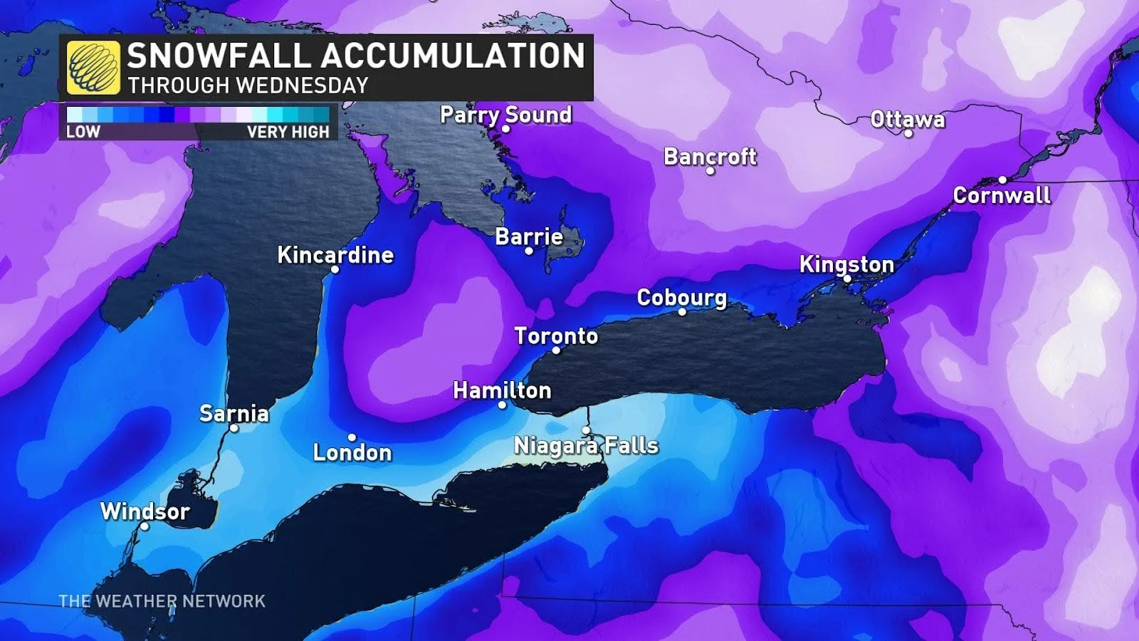
Communities in and around Toronto could see 2-8 cm of snow on Tuesday before the precipitation changes over to rain. Areas close to Lake Ontario will see minimal snowfall and change to rain sooner.
We could see 20-30 mm of rain from this system on top of any snow that falls, making for a sloppy situation for travellers.
MUST SEE: Record-breaking: El Niño stole winter from Ontario in December
Environment and Climate Change (ECCC) Canada has issued special weather statements north of the Greater Toronto Area (GTA) into cottage country—including Barrie, Collingwood, and Orillia—advising for the winter weather potential on Tuesday.
“Snowfall warnings or winter weather travel advisories may be issued for some regions as this event draws nearer,” ECCC said in its statement.
Winter storm watches are in effect for portions of central and eastern Ontario, where forecasters expect the system to produce more widespread wintry precipitation.
Colder air will hang on for a bit longer across eastern Ontario at the onset of the storm there, allowing for more wintry precipitation before the changeover to liquid rain.
Folks around Ottawa could see up to 15 cm of snow, with a risk for ice pellets or freezing rain near the Ontario/Quebec border before the changeover to rain.
Farther west, the track of the storm may allow North Bay and Sudbury to remain all-snow for the duration of the event, allowing the communities to pile up as much as 25 cm of snow through Wednesday.
Quebec faces shifting precipitation
The situation isn’t much better next door in Quebec, where the whole spectrum of precipitation is possible.
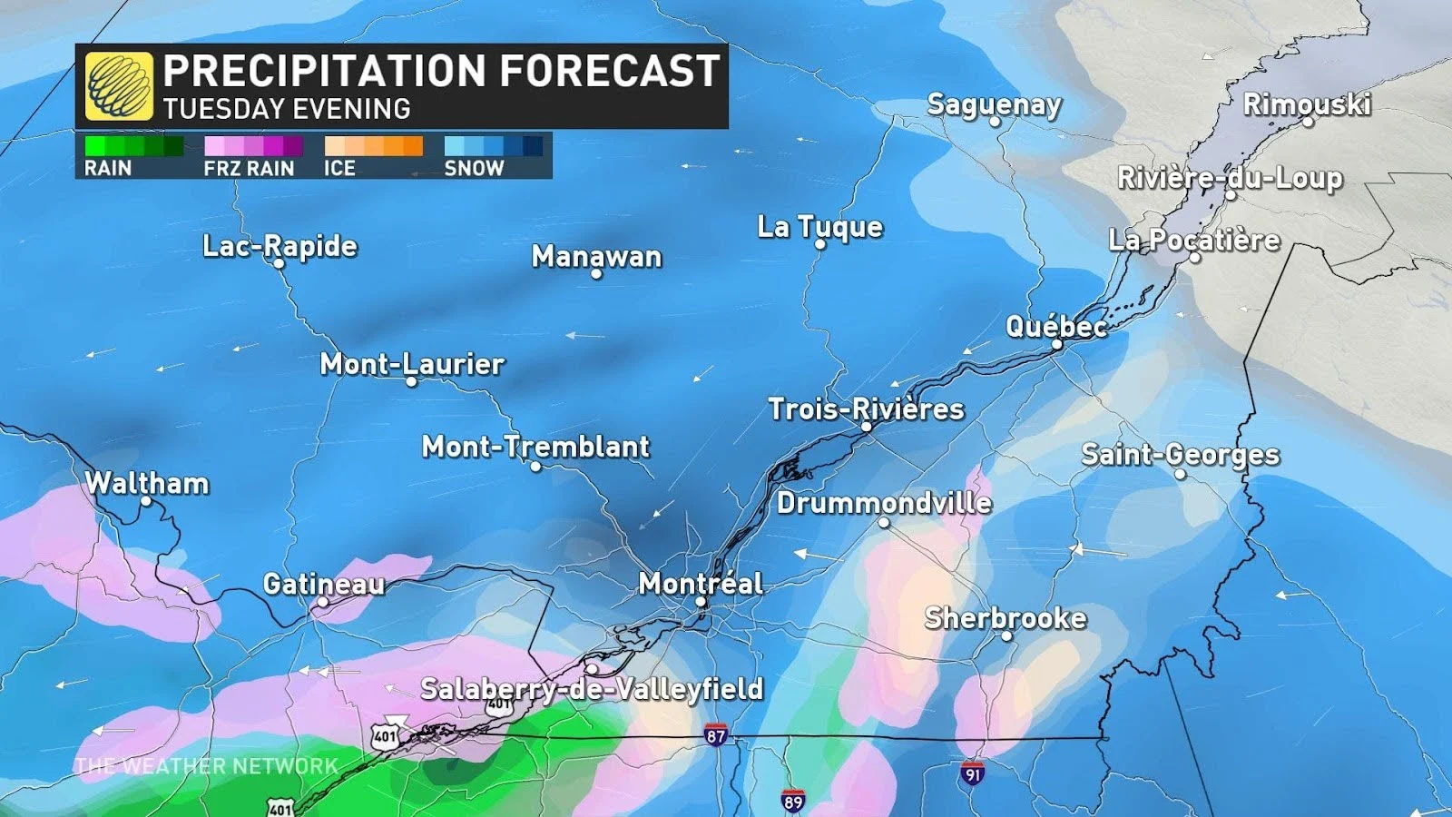
Southern Quebec and metro Montreal are in the same boat as Ottawa, where colder air will allow for a longer period of snowfall before the inevitable changeover to rain as warmer winds push in from the south. Freezing rain and ice pellets are also possible during this transition.
The Montreal area could see up to 15 cm of snow before this changeover.
Precipitation will remain all-snow for a large swath of interior Quebec, with hefty snowfall totals likely alongside gusty winds across central and eastern parts of the province.
ECCC issued a special weather statement for all of Quebec ahead of the storm. “Hazardous travel conditions can be expected. Utility outages are possible. Consider modifying any non-essential travel plans,” the agency said late Sunday.
Gusty winds likely through Wednesday
The low-pressure system’s impressive minimum pressure will fall to about 975 mb as it churns across Lake Huron, which is unusually low for any system trekking through the area any time of year. January’s record-low air pressure sits in the 960s, though, so our current storm is rare but not unprecedented.
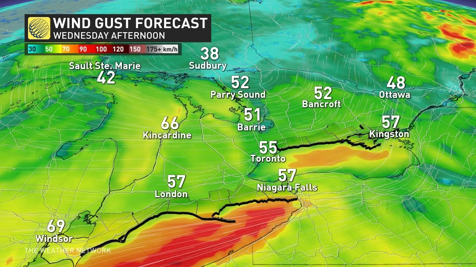
All that energy will convert into gusty winds across the entire breadth of the storm.
Very strong winds will develop over southern Ontario on Tuesday, with sustained southwesterly winds up to 60 km/h blowing across Lake Erie and Lake Ontario. Wind gusts up to 90 km/h are possible on Wednesday as the low moves north of the region.
Header image courtesy of Ajaykumar Kannan/Unsplash.
Stay with The Weather Network for the latest on this major storm in Ontario and Quebec.